Summer 2002
Summer 2002 |
|||||||
|
|
|||||||
Leaving on a Jet Plane
NextJet Employs GIS for Same-Day Nationwide Air Courier Service |
|||||
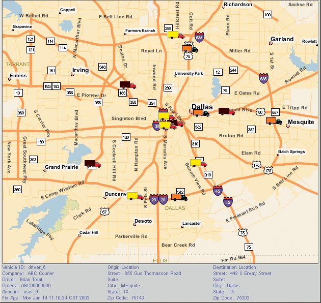
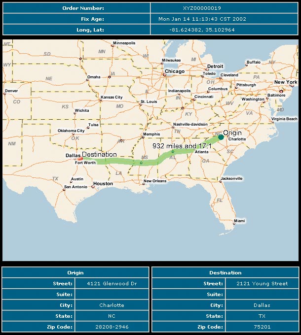
Sometimes overnight isn't fast enough. Very often, a Business absolutely needs a part, a plan, or a package that same day. That is the basic proposition on which Joseph Lane and Steve O'Brien built NextJet, their nationwide air courier service. A speed demon in the already fast-paced expedited shipping industry, which the Colography Group estimated at $85 billion in the United States in 2000, NextJet specializes in immediate response logistics. In other words, it delivers the goods "today." The Dallas-based company combines state-of-the-art technology with old-fashioned street smarts to offer same-day pickup and delivery of packages virtually anywhere in the United States. The fastest method of door-to-door package shipping available today, the company's NextJetOut service uses a proprietary transit management system to track more than 30,000 daily commercial airline flights and orchestrate the movements of couriers and local affiliates. When Lane and O'Brien launched the company in 1999, they developed their own highly effective system to move same-day air shipments beyond the commonly used airport-to-airport service. However, moving a package from Logan Field in Boston to Los Angeles International Airport in California in the shortest possible time is only part of the equation. What customers care about is how soon the package can be at their doorstep, not how soon it can arrive at their local airport. As the NextJet door-to-door same-day service went into operation, the importance of utilizing highly reliable and precise mapping data became critical. The NextJet system creates routes based on tight windows, so every minute a driver is in motion counts. "In our Business, time really is money," says Brent Hudspeth, vice president of marketing for NextJet. "A customer waiting for the part he needs to restart his idled assembly line does not want to hear that his package will be an hour late because our driver didn't know that the Seventh Street Bridge was closed for repairs. To provide the fastest delivery service in the nation, we need the most accurate and up-to-date digital maps available. Our reputation rides on them, so we demand the very best." Fueled by Spatial Data and the InternetAfter testing various products, NextJet found that spatial data from Tele Atlas/TomTom North America, an Esri Business Partner based in Menlo Park, California, afforded it the control it needed at a competitive price. NextJet uses the data atop Esri's ArcIMS Route Server extension. This combination simplifies geocoding, routing, and data rendering to maximize the speed and functionality of the NextJet system. NextJet uses the spatial data compressed format provided by Tele Atlas/TomTom to geocode pickup and destination locations and provide the street data that enables it to calculate the most efficient routes possible and execute its trademark same-day delivery service. With the functionality of ArcIMS and the foundation of accurate map data, NextJet is able to provide efficient and timely solutions.
How It WorksWith the click of a mouse or a toll-free telephone call, NextJet customers can arrange same-day deliveries anywhere in the United States. Routing, scheduling, and pricing information are all available instantly to the customer. NextJet automatically selects optimal shipping solutions by digitally linking commercial airline schedules and ground couriers. NextJet's technology delivers itineraries that include courier pickup, placement on the next available flight(s), courier retrieval from destination airport, and delivery to final location. NextJet's proactive tracking system, Nextrac, sends real-time shipment information to users via various methods including e-mail and phone. The spatial data and the compressed format provide the flexible, server-based data delivery method that NextJet needs to integrate into its complex multimodal transportation routing system. For more information, contact Brent Hudspeth, NextJet (tel.: 214-292-3101, e-mail: brent.hudspeth@nextjet.com), or Tele Atlas/TomTom North America (tel.: 650-328-3825). |