Summer 2003
Summer 2003 |
|||||||
|
|
|||||||
ArcGIS 9: Major New Release of the ArcGIS Platform |
||||||
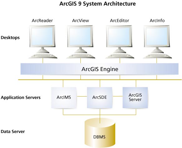
ArcGIS 9 is the next major release of the ArcGIS system. ArcGIS 9 will extend the current platform with major new capabilities in the areas of geoprocessing, 3D visualization, and developer tools. Two new products, ArcGIS Engine and ArcGIS Server, will also be launched. Compatibility, Quality, and Ease of UpgradeA major goal of ArcGIS 9 is complete compatibility with existing ArcGIS 8.x functionality and data models, making it easy for end users and developers to upgrade their systems. Considerable effort is also being put into software quality, testing, and performance with ongoing importance in geodatabase scalability and raster handling. Advanced GeoprocessingArcGIS 9 introduces major new capabilities for geoprocessing (spatial analysis). Along with mapping and data management, geoprocessing is one of the fundamental capabilities of GIS software. Geoprocessing allows users to perform advanced spatial analysis and automate frequently performed tasks such as site suitability analysis and merging data sets. Traditionally, ArcInfo Workstation and ARC Macro Language (AML) have been used to undertake such tasks. With the release of ArcGIS 9, all the key workstation geoprocessing functionality and more will be available in ArcGIS Desktop and will work with all supported data formats including geodatabase feature classes. ArcGIS 9 geoprocessing comprises two parts: a framework for hosting functions, models, user interface tools and dialogs, and scripts and an extensive collection of tools. The geoprocessing tools in ArcGIS 9 can be used in a number of ways. Users can run tools from a dialog, compose visual models interactively, and use an intelligent command line to execute a tool or write scripts that use multiple tools to automate geoprocessing tasks:
At ArcGIS 9, ArcToolbox becomes a dockable window within ArcMap, ArcCatalog, ArcScene, and ArcGlobe. In keeping with the scalable ArcGIS Desktop design, the ArcToolbox geoprocessing framework is common across ArcView, ArcEditor, and ArcInfo. It is the number of tools that varies between products: ArcView and ArcEditor have approximately 30 tools, and ArcInfo has approximately 200 tools. ArcGIS extensions, such as ArcGIS 3D Analyst and ArcGIS Spatial Analyst, expand the toolbox and provide more than 200 additional tools. Examples of tools include
ArcGlobe: Revolutionary 3D GISArcGIS 9 3D Analyst introduces whole earth 3D visualization into GIS for the first time. These capabilities are encapsulated within a new 3D desktop application called ArcGlobe.
ArcGlobe now has the ability to seamlessly interact with any available geographic information as georeferenced data layers on a 3D globe. ArcGlobe allows users to visualize geographic data by putting the data in the context of the whole earth. Leveraging extremely efficient and highly optimized data retrieval and display techniques, ArcGlobe can provide access to virtually unlimited volumes of geographic information. These breakthrough capabilities mean that ArcGlobe can easily and intelligently handle raster, vector, and terrain data sets representing data from local to global scale, with performance exceeding traditional 2D mapping. Using familiar interactive mapping tools, users can pan, query, and analyze data at a global scale, or they can zoom in to their local area and view very high-resolution aerial photography of their neighborhood. This is achieved using a new, advanced indexing and multiresolution data access technique. Users will only be limited by the size of their storage devices and the accessibility of the data. ArcGIS 9 3D Analyst also adds support for true 3D symbology to enhance scientific visualization and real-world simulation. Major Contribution to Standards and Interoperability: Open Geodatabase FormatAs part of Esri's ongoing commitment to practical interoperability, ArcGIS 9 will feature publication of a standard, open format for geodatabases. This will take the form of an XML schema that provides access to all database types (e.g., vector, raster, survey measurements, and topology). This "GML profile" will allow users to publish data models and to share geodatabase data sets in a completely open and interoperable environment. This will greatly facilitate the sharing of framework and other base data sets. Esri envisions that this will have the same impact on the GIS community as publication of the shapefile specification in the 1990s and that it, too, will rapidly become an industry standard for reading and writing geographic information. Enhanced Raster SupportArcGIS 9 includes significant enhancements to raster storage, management, query, and visualization. These enhancements will be especially noticeable for users with very large raster geodatabases (hundreds of gigabytes to terabytes). A new user interface will be introduced to manage, explore, and create rasters. ArcGIS 9 will also add raster attribute and spatial-based querying and selection. Rasters become a full-featured part of the geodatabase at ArcGIS 9, allowing for versioning on raster tables and relates and storing rasters and vectors together. New for Developers: ArcGIS Engine
ArcGIS Engine is a developer product for creating and deploying ArcGIS solutions. ArcGIS Engine is built from ArcObjects, the cross platform, C++ component technology framework used to build ArcGIS. With ArcGIS Engine, developers will be able to build solutions and deploy them to customers without requiring the ArcGIS Desktop applications (ArcMap, ArcCatalog) to be present on the same machine. ArcGIS Engine supports all the standard development environments, including .NET, Component Object Model (COM), Java, and C++, and all the major operating systems. In addition, developers will be able to embed some of the functionality available in the ArcGIS extensions. New Server-Centric GIS: ArcGIS ServerThe most significant architectural change to be introduced at ArcGIS 9 is ArcGIS Server. Until ArcGIS 9, advanced GIS functionality has only been available for desktop PCs. Client/Server computing provides shared access to common data in a database, and Internet computing allows data to be published for Web access; however, it has not been possible to build a centrally managed, network-centric, server-based GIS with full GIS capabilities. This is the vision of ArcGIS Server. During the development of ArcGIS 9, Esri has restructured the core ArcGIS platform to be hosted on server computers; to run on all major server platforms; to support all common development environments (.NET, Java, COM, C++); and to include all the powerful mapping, query, analysis, and geoprocessing capabilities currently available in the ArcGIS Desktop products. ArcGIS Server 9 is designed primarily for enterprise information system developers/integrators who wish to build serverside GIS applications in either a client/server or Web services environment. It is complementary to Esri's two other enterprise application servers: ArcSDE, which is used to access spatial data in a commercial database management system (DBMS), and ArcIMS, which is used for high-volume Internet geopublishing. For more information on ArcGIS, visit www.esri.com/arcgis, call Esri at 1-800-447-9778, call your Esri regional office, or contact your local reseller. Outside the United States, please contact your local Esri distributor.
|