Summer 2004
Summer 2004 |
|||||||
|
|
|||||||
The ArcGIS S-57 ENC Nautical Data Model |
|||
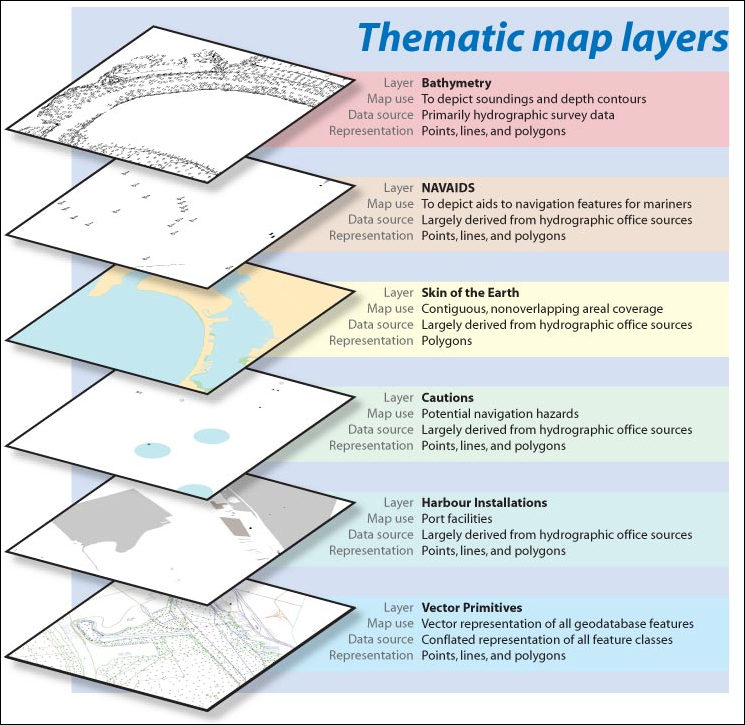
Esri's ArcGIS S-57 ENC Nautical data model incorporates the S-57 standard for Electronic Navigational Charts (ENCs) developed by the International Hydrographic Organization (IHO). Portions of the ArcGIS S-57 ENC Nautical data model [PDF-3.76 MB] illustrate the best practices and methods for managing nautical data in the ArcGIS geodatabase using Esri's Production Line Tool Set (PLTS)–Nautical Solution, while adhering to these robust international specifications. The model was designed as a solution to accommodate ENC data sets produced in compliance with the IHO Transfer Standard for Digital Hydrographic Data (Special Publication No. 57, Edition 3.1). The ArcGIS S-57 ENC Nautical data model can be used with PLTS Nautical Solution for a complete end-to-end solution to create and maintain S-57 compliant ENC data. Although the data model can be implemented without Nautical Solution, the solution provides the data management, topology, and rendering tools to fully take advantage of the model and efficiently automate ENC data production. The goal of this model is to provide a mechanism for capturing the behavior of ENC data sets in a production geodatabase used for maintenance and editing. Previous ENC S-57 data models did not account for concepts such as one-to-many primitive feature relationships, master–slave relationships, and collections that are critical to ENC. The S-57 ENC Nautical data model and Nautical Solution provide capabilities to incorporate these key concepts into the creation and maintenance of ENC cells. By utilizing a topology graph, the planar geometry of every feature in the geodatabase can be represented. Also, topology rules have been implemented to include IHO Special Publication No. 58 Recommended ENC Validation Checks, Edition 2.0. Some fundamental aspects of the model key to ENC users are the ability to
The geodatabase domains, along with the topology rules, have been developed to provide the ability to edit and maintain ENC data with the PLTS–Nautical Solution. The domains provide confidence that the underlying ENC model maintains the rigid S-57 ENC attribution guidelines. Topology rules ensure conformance to spatial integrity rules defined in the S-57 ENC specifications. Why is the S-57 ENC Nautical data model important? A data model that maintains topological integrity of the integrated S-57 data objects is critical for hydrographic organizations. The S-57 ENC Nautical data model and Esri's PLTS–Nautical Solution represent a practical implementation that leverages today's GIS technology. For more information, select the Nautical link at support.esri.com/datamodels. |