Summer 2005
Summer 2005 |
|||||||
|
|
|||||||
Field Mapping Time Cut in Half
Edgecombe County, North Carolina, Maps and Inventories Water/Wastewater Infrastructure with GIS and GPS |
|||||
|
Charm, hospitality, and environmental stewardship are the three qualities for which Edgecombe County, North Carolina, likes to be known. Located between the city of Raleigh and the famous North Carolina beaches, the county's brick-paved sidewalks and town commons preserve its charm, while the natural friendliness of the 56,000 residents makes Edgecombe a hospitable tourist destination. The county government is doing its part to carry on the tradition of protecting the natural resources.
As is occurring in much of the United States, a predominantly agricultural economy is gradually giving way to manufacturing and other light industry. But rather than welcome just any factory or plant into the county, Edgecombe business developers have set their sights on attracting environmentally friendly companies. Specifically, they want to make sure that new businesses don't pollute the freshwater aquifer. "Environmental stewardship is a lifestyle here," says County Manager Lorenzo Carmon. "The state informed us a few years ago that the aquifer is drying up, which motivated us to better safeguard the water supply." That motivation led to a $40 million engineering and construction project that will eventually replace the entire water and wastewater system in the 505-square-mile county. In early 2005, about midway through the project, Edgecombe decided to initiate a parallel project that would map and inventory the entire water/wastewater infrastructure, both old and new. This database would reside inside the county's existing GIS. This project would require field mapping more than two dozen feature types and collecting up to 15 attributes per feature along 400 linear miles of water and sewer transmission mains. Mapping crews would have to accurately locate and collect attribute information for every pressurized line, gravity line, manhole, control valve, storage tank, fire hydrant, meter vault, and pump station. Mapping would drill down to the level of individual pump stations and meter vaults, including their method of treatment and the types of pumps and meters they contain. The decision to map the water/wastewater infrastructure was driven by three factors:
Without the staff to perform the mapping, Edgecombe turned to The Wooten Company, a Raleigh-based engineering, planning, and architectural design firm. The county chose Wooten because the firm already was performing the preconstruction engineering work for the water/wastewater upgrade project and was, therefore, familiar with the components to be mapped. The county also knew that Wooten maintained survey crews for site mapping projects. Known for its willingness to adopt new technologies to accommodate the diverse and changing needs of its clients, the firm saw both a challenge and an opportunity in the mapping contract.
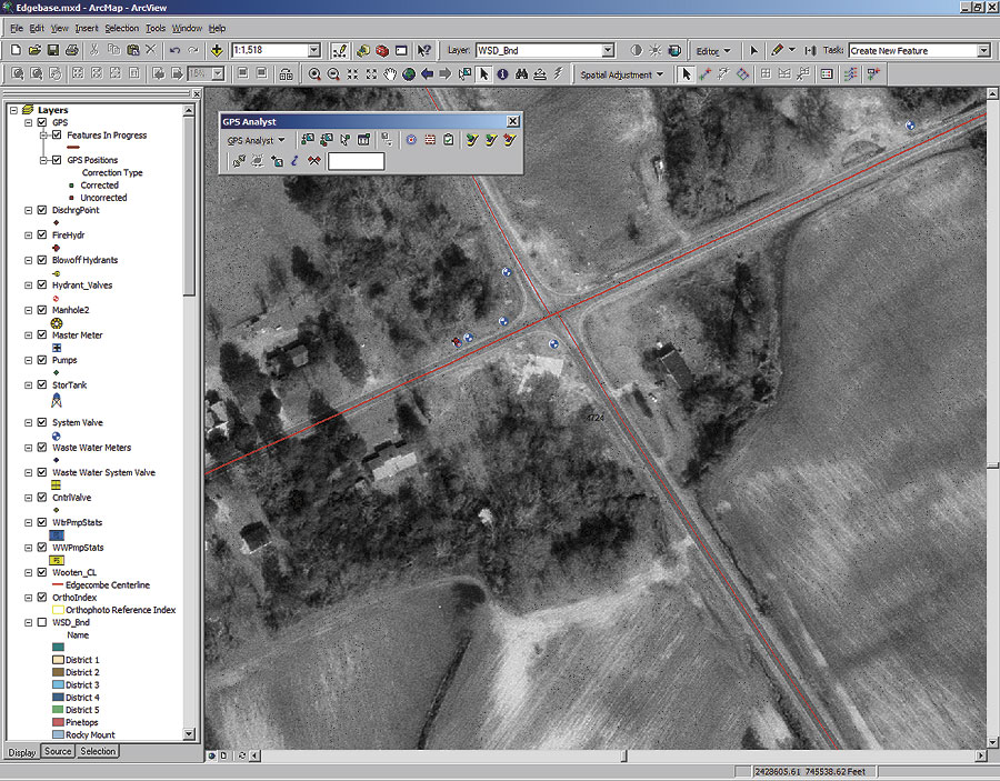
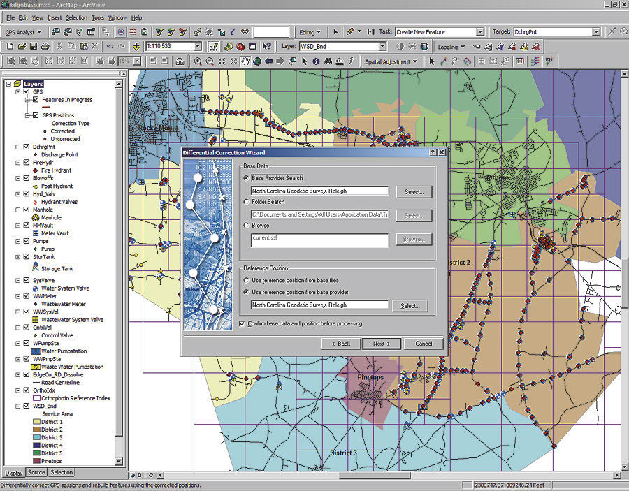
For previous asset mapping projects, Wooten had exclusively used traditional survey technology in the field; however, with a two-month deadline and thousands of features to collect, the firm knew it couldn't use survey equipment to complete the project. The time was right for its planned switch to GPS technology for field mapping. Wooten decided to use Trimble's GeoExplorer series. This product line had been selected because it combines a submeter GPS receiver and a handheld GIS data collection computer in a single ruggedized unit for rapid collection of attribute and location data. But before making the purchase, Wooten wanted to ensure there would be direct compatibility between the new GPS equipment and the firm's existing suite of Esri GIS software. It planned to build the Edgecombe geodatabase with ArcView 9. Alex Fuller, Wooten GIS coordinator, says, "We knew from experience that to get maximum benefits from two technologies that are meant to work together, the integration between them must be fast, seamless, and easy." The engineering firm obtained a bundled hardware-software package, which included a Trimble GeoExplorer GeoXT equipped with Esri's ArcPad mobile GIS software and the Trimble GPScorrect postprocessing extension. In addition, Wooten acquired Trimble's GPS Analyst, a new ArcGIS extension that creates a seamless work flow between GPS data collected in the field and the enterprise geodatabase in the office. Edgecombe County's only existing water/sewer system schematic resided in CAD format and was not drawn in such a way that it could be readily referenced into the geodatabase. Wooten printed the diagrams as field workbooks to assist in locating system features in the field. With guidance from the county, the firm's GIS specialists generated data models, or classification structures, of the attributes that would be collected in the field for each type of infrastructure asset and created a geodatabase based on the data model that had been created. Attribute and location data would be gathered simultaneously during the field mapping. At the beginning of each day's fieldwork, which mostly takes place on the dusty shoulders of roads and highways running beside the water pipe rights-of-way, Wooten technicians open the GPS Analyst program running inside ArcGIS on a laptop computer to "check out" the datasets to be mapped. This means the geodatabase files relating to those infrastructure features that will be mapped or updated are selected and uploaded by USB cable link from the laptop into the handheld GeoXT. In the field, ArcPad displays a schematic of the water system assets that will be mapped. As the field crew finds each feature, an on-screen point-and-click menu generated from the data file assists the user in collecting the desired attribute information. As the crew member enters the descriptive data into ArcPad, the GPS receiver records 20 location points for each feature in less than one minute. This location data is stored with the other attribute data in the mobile geodatabase inside the GeoXT. "Usually the record drawing gives us a pretty good idea of where the pipes run," says Fuller, "so we know where to look for valves and other features, but sometimes we find a fire hydrant where there is no record of one existing. We simply add it to the database. This is where field mapping will really pay off for the county." Completely transparent to the Wooten field technician, the Trimble GPScorrect extension is also running inside ArcPad, collecting additional data from the GPS satellites that will be required later to postprocess the location data recorded by the receiver. Differential postprocessing allows the crew to enhance the accuracy of the location data to less than one meter. "This mobile GIS solution has more than doubled the number of small features, such as valves, manholes, and fire hydrants, that we can collect in a day compared to traditional survey techniques," says Fuller. Once the fieldwork has been completed for the day, the crew reconnects the GPS receiver with the laptop computer to download field data into the ArcGIS geodatabase. Working in ArcGIS, the GIS specialist then accesses GPS Analyst to differentially correct and edit the GPS points collected in the field. Differential correction of GPS data previously involved exporting the GPS data to an external software package first, but now Wooten technicians perform the task of postprocessing data within the geodatabase. They click on the differential correction tool and select from a list of local reference station sources. The differential correction wizard within GPS Analyst assists in determining which source provides the best coverage for that day's points, then connects with the base data provider to access the appropriate correction data. The software completes the postprocessing automatically inside ArcGIS within minutes compared with the hour or more it once took to export data and correct it externally. The GPS Analyst extension also allows the Wooten field crews to validate GPS points by visualizing each of the 20 location values collected for every fire hydrant and manhole shown on-screen. By looking at the data cluster, they can determine which points are not consistent with the others. With a mouse click, these errant points can be deleted to improve the average value of the remaining points and thus the accuracy of the overall feature map. Once the field data has been collected, Wooten overlays the new layer of water and wastewater features on a digital orthophotograph of Edgecombe County. Many of the larger assets, such as pump stations, water storage tanks, and meter vaults, are readily visible on the orthophoto. GIS specialists compare the location of the features mapped in the field with those visible on the orthophoto. They have determined accuracy of the data collection is well within the one meter mandated by Edgecombe County. For more information about this project, contact Lorenzo Carmon, Edgecombe County manager (tel.: 252-641-7885, e-mail: lcarmon@co.edgecombe.nc.us), or Alex Fuller, The Wooten Company (tel.: 252-828-0531, e-mail: afuller@thewootencompany.com). |