Summer 2006
Summer 2006 |
|||||||
|
|
|||||||
GIS, GPS, and AVL Technologies at the Hartford, Connecticut, Fire Department
Fighting Fires in the 21st Century |
|||||||
|
By Ewe-Leng Lim, P.E., Chief Knowledge Officer, Institute of Information Technology, Inc.
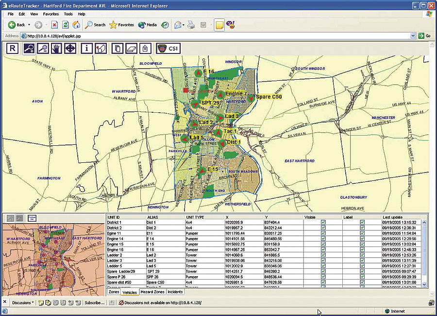
A few years ago, HFD's first implementation of computer mapping technology used a simple GPS and AVL system to track the department's fire apparatus (vehicles) in real time. Although the system initially adopted was adequate in displaying where the vehicles were in real time, it lacked the ability to show other layers of interest to HFD, such as the locations of fire hydrants, water pipelines, building footprints, parcels, and aerial photos. More important, HFD wanted to make all that information available to the firefighters in the field where they could point to a hydrant on a digital map and quickly see information about the diameter of the connected pipeline to determine which hydrant to best use to fight a fire. In the past, the firefighters used huge foldout paper maps and schematic pipelines with hydrant sizes and locations that each fire vehicle carried around in a big three-ring binder. What was missing was the GIS component to the GPS/AVL application. With this deficiency in mind, deputy chief Eugene Cieri and Carolyn Shumate from the city of Hartford's Metro Hartford Information Services Division attended one of a series of mobile GIS seminars organized by Esri's regional office in Danvers, Massachusetts. The Institute of Information Technology, Inc. (IIT), an Esri Business Partner, was one of the presenters at that seminar where it showcased its eRouteTracker—a combination of GIS, GPS, and AVL technologies that IIT had developed for the Newton Police Department, city of Newton, Massachusetts. This solution presented the missing GIS component that would meet the needs of HFD.
Teale, along with deputy chief Daniel Nolan who heads the fire training academy, came up with the concept of a Community Safety Information (CSI) system that would enable the department to gather voluntary information from the general public to help HFD be better prepared before getting to the scene. "There'll be a constant reminder to the general public to contact us with the information they want us to know, so that we will know what we're dealing with," says Teale. "Included in the CSI program is the capture of building images from all sides of the building. The goal is to have firefighters get to scenes faster, be better informed ahead of time, and make the public safer." During an actual scene of a fire captured by the local news, Nolan says, "With this system, we were able to identify the hydrants outside of the addresses, the water mains, the sizes of the water mains, and information inside the house—how many children, their ages, if they have any ailments, or if there is anyone with a disability." Teale further emphasized that HFD is taking a proactive approach to show that it cares for the safety of the public. HFD applied for and received GIS-related grant funding for homeland security-related projects, which has helped the department further enhance the application. Part of the grant was applied to obtaining newer equipment, including laptops, wireless modems, cellular services, and a thermal printer that provides outputs on waterproof paper for use in the field to print information on chemical hazards, etc. Feedback from the field is continually being incorporated into new releases of the application.
Aerial photos overlaid with other GIS layers provided the fire commanders with information previously not available, such as the layout of buildings relative to images of parking lots, fenced access, building quadrangles, etc., to better determine the best staging area or alternate access to a specific building structure. In addition, the software provides routing capabilities to show the quickest route to get to the scene of a fire. The MDC client has role-based security, which means, for example, a supervisor user will be able to see all vehicles in real time while regular users may only see their own vehicles. "This is a good example of how we can combine different cutting-edge technologies, such as J2EE and .NET, into one seamless application while leveraging an organization's existing infrastructure," explains Sergiy Savchenko, IIT's technical lead on this project. The MDC AVL clients are deployed on rugged touch screen Panasonic Toughbook laptops to meet the harsh environments associated with firefighting equipment. The touch screen and simple user interface make it easy for firefighters to navigate the mapping environment and obtain the information they need literally at their fingertips. "I could see there was a vacant parking lot back there, and that in itself was advantageous to report to the incoming company to utilize the back to stop the progression of the fire on the rear side of the building," says deputy chief Carlos Huertas, describing a recent incident where he used the application to direct response to a firefighting scene. More InformationFor more information, contact deputy chief Eugene Cieri, Hartford Fire Department, City of Hartford, Connecticut (e-mail: ecieri@hartford.gov, Web: www.hartford.gov/fire), or Ewe-Leng Lim, PE, chief knowledge officer, Institute of Information Technology, Inc. (e-mail: elim@e-iit.com, Web: www.e-iit.com). |