Summer 2006
Summer 2006 |
|||||||
|
|
|||||||
City of Philadelphia's Streets Department Takes on New Business Systems
GIS-Based Work Order Management System Tailors Workflows |
|||||
In Pennsylvania, the city of Philadelphia's Streets Department faced such challenges in its implementation of a computerized work order management system. And being a strong user of GIS, the department specifically sought a system that could leverage and extend its investment in GIS data while meeting the specific needs of a wide array of departmental uses. The department sought an extensible, GIS-centric system that could be implemented easily and efficiently using in-house Streets Department Information Technology staff and could be layered within the existing technology infrastructure. Project OverviewIndividually targeting specific groups within the Streets Department Information Services and Technology Unit (IS&T) tailored a methodical approach to ensure three key goals:
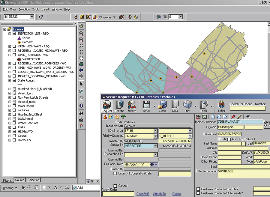
With these goals in mind, IS&T selected Cityworks software from Esri Business Partner Azteca Systems (Sandy, Utah) because of its GIS-based design and flexibility to span organizational needs. IS&T then initially deployed the GIS-based system in a pilot project to address specific work unit application requests received by IS&T. This allowed the city's implementation team to learn the inner workings of the system using technical manuals and remote support before tackling more robust, live operations. Concrete OperationsThe Highway Division's Concrete Operations Unit was the first to be implemented. A discrete work unit that needed only one task in its workflow, They were looking for an easy-to-use system that could track crew productivity and material usage. Meeting with the Concrete Operations supervisor, IS&T developed a list of work order templates and created a single task, Pour Concrete, with the knowledge that a full-scale implementation for the Highway Division would require the addition of many more tasks to these same work order types. The first step was to set up the system environment. The Streets Department already had a Citrix server farm for the deployment of other applications, including ArcView. It was logical to implement Cityworks, an extension to ArcView, via Citrix as well, creating an ArcView document specifically tailored to Concrete Operations' needs. The GIS data that would be used as assets was held in ArcSDE using Microsoft SQL Server. These assets were streets, stored in two feature classes�arcs (streets) and nodes (intersections). The actual work order management database was set up in SQL Server. Reports were designed using Crystal Reports and delivered to Concrete Operations' users via a custom application deployed via Citrix. Real data entry began in January 2004. Alley Lights
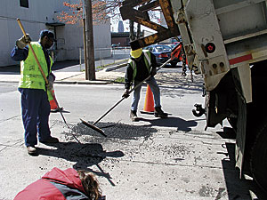
IS&T then moved on to assist Street Lighting, upgrading its system for tracking alley light maintenance. This deployment required the ability to respond to customer calls along with the need to import five years of existing data. This gave the city's implementation team the opportunity to learn about using the system in a more comprehensive process. Meetings were held and workflow diagrams were created to analyze and enhance the business process before the maintenance management system was deployed. The assets used, in this case, are a subset of the GIS pole layer and, using an ArcSDE spatial view of this subset, allow street lighting users access to existing data without any changes to the data structure or maintenance process. Right-of-Way InspectionsThe implementation team next took on the Right-of-Way Unit, which is responsible for the inspection of work performed on city streets. The source of the majority of its work orders is the Streets Department's permit system. This required the development of an import routine, to be run by the supervisor, that reads the Street Closure Permit System database and creates work orders in Cityworks. This was similar to the import routines developed to upload the existing data for alley lights, so the skill set was already available. The process also includes the creation of a digital copy of the permit as an attachment to the work order. Inspections are done using the custom inspection templates in the system. Photos and drawings are stored in an attached spreadsheet created by the inspectors. Smooth StreetsThese first three implementations involved a small number of users, affording an excellent way to learn the system. In the summer of 2005, the Highway Division asked to expand Concrete Operations' system to the full repair process for plumbers' repair ditches and water ditches. This required the addition of five additional standard tasks to the work order types used by Concrete Operations, plus many different alternate tasks to accommodate special situations. It also included nightly synchronization with data from the city's Water Department. The implementation started out slowly, based on limited resources and other priorities. In early 2006, the Mayor's Office announced a new initiative called Smooth Streets. This initiative required the acceleration of street repairs with the goal of repairing potholes the next business day and performing the permanent restoration of ditches within 30 days of their creation. The department realized that meeting and measuring these goals would require a full-scale implementation of the maintenance management system. The implementation team rose to the challenge, adding all Highway Division service request and work order types, special event layers to display data, new reports, and custom ArcView documents for customer affairs representatives and inspectors who would determine the validity of citizen calls. The inspectors were also provided with wireless laptops, and the existing Citrix Secure Gateway was used to allow data entry in the field. This process required the training of nearly 100 users. A Web-based application was also developed to allow citizens to report potholes. This application uses existing ArcIMS software-based Web services, provided by the Mayor's Office of Information Services GIS Services Group, to verify addresses and assign districts. This data is automatically imported into the system as part of the nightly inspection. The resulting implementation has provided Philadelphia's Streets Department with a personalized configuration that delivers exact and immediate results to end users, allowing system expansion and modifications to be quick and easy. More InformationFor more information, contact Marion Storey, IT Applications Program manager, Philadelphia Streets Department (tel.: 215-686-5031, e-mail: marion.storey@phila.gov), or George Mastakas, director of Professional Services, Azteca Systems (e-mail: georgem@azteca.com). |