|
| |

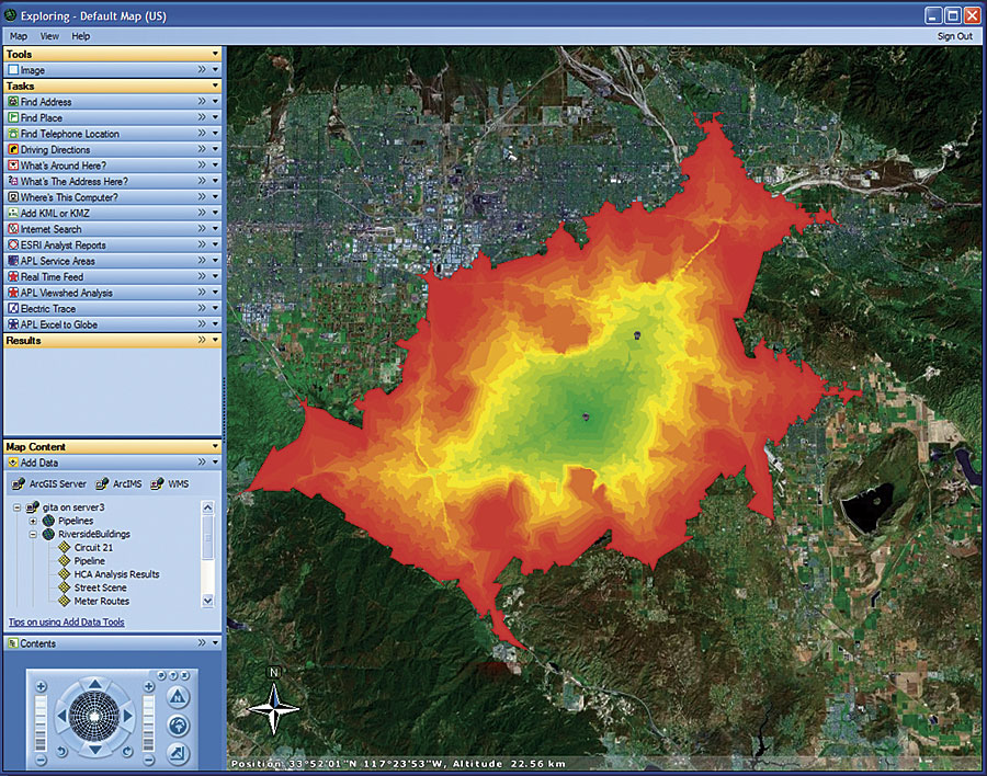
ArcGIS Server Advanced Edition includes a collection of advanced Web applications and services. In this example, ArcGIS Server Advanced Edition is being used to provide custom tasks to ArcGIS Explorer. |
ArcGIS 9.2 delivers a comprehensive Web-based GIS server that supports geographic data management, mapping, spatial analysis, editing, and other GIS functionality across distributed systems. To achieve this, Esri has integrated ArcSDE technology into ArcGIS Server to provide a single product encompassing Web GIS technology and comprehensive data management technology (ArcSDE).
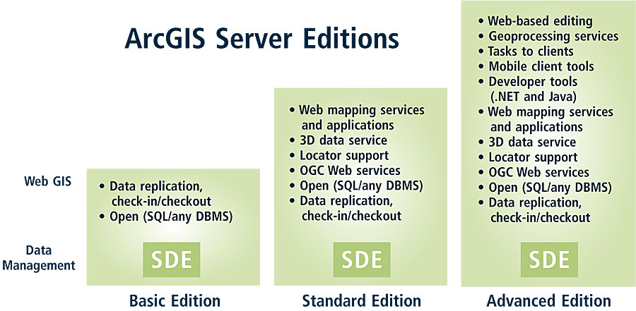
ArcGIS 9.2 Server offers a scalable line of server product editions built on a common set of technology components that are distinguished by both functionality and server capacity. There are three editions for ArcGIS 9.2 Server: Basic, Standard, and Advanced. To better assist the geographic data management needs and requirements of server users, ArcSDE technology is included with all three editions of the ArcGIS Server product:
- ArcGIS Server Basic Edition—ArcGIS Server Basic Edition is designed for GIS users who want shared access to geographic data. It provides core geodatabase management tools and technology for data storage, management (ArcSDE), and distribution (Web-based data replication).
- ArcGIS Server Standard Edition—ArcGIS Server Standard Edition is designed for GIS users who want to visualize and publish geographic data as maps and globes. ArcGIS Server Standard Edition includes all of the functionality of the Basic edition plus a collection of 2D and 3D Web mapping/geopublishing tools, applications, and services. Application developers will have access to components (objects, Web controls, and services) for building solutions on both the Java and .NET frameworks.
- ArcGIS Server Advanced Edition—ArcGIS Server Advanced Edition is designed for GIS organizations that want to provide a central, server-based GIS for distributing GIS services across the organization or over the Internet. ArcGIS Server Advanced Edition is the most functionally rich edition of ArcGIS Server. It includes all the capabilities of the Basic and Standard editions, plus it offers a collection of advanced Web applications and services. These applications and services include a browser-based editing application, numerous geoprocessing services, the ability to supply custom tasks to ArcGIS Explorer clients, and much more. For developers, ArcGIS Server Advanced Edition includes multitiered components for building and deploying both J2EE and .NET 2.0 applications and services for traditional desktop, mobile, Smart Client, and enterprise deployments.
All editions of ArcGIS Server will be available at a workgroup level with an embedded DBMS (SQL Server Express) and at an enterprise level for use with various enterprise class DBMSs.
Other ArcGIS Server Enhancements
| | 
ArcGIS 9.2 Server consists of Web GIS technology and SDE technology. It will be available in a scalable line of editions, with increasing levels of functionality. |
In addition to the integration of ArcSDE into ArcGIS Server, ArcGIS 9.2 Server includes many other new enhancements. ArcGIS 9.2 Server delivers numerous out-of-the-box end user applications and services (e.g., viewers and browser-based geodatabase editors) for mapping, analysis, collection, editing, distribution, and management of spatial information.
ArcGIS 9.2 Server also complements ArcGIS Desktop by allowing GIS analysts to author maps, globes, and geoprocessing tasks on their desktop, then publish them to ArcGIS Server using integrated tools. Furthermore, ArcGIS Server supports numerous standards and industry specifications and can publish 2D maps adhering to Open Geospatial Consortium Web Map Service specifications, as well as 3D globes to the KML specification.
ArcIMS 9.2 Enhancements
ArcIMS will continue to be available and supported with the release of ArcGIS 9.2. In fact, ArcIMS 9.2 has many significant enhancements, including a new Web application and new developer components. ArcIMS users will receive ArcGIS Server Standard Edition as part of their maintenance, which means that ArcIMS users can use both ArcIMS and ArcGIS Server Standard Edition on the same machine. Also, all existing ArcIMS applications will continue to work at version 9.2.
Highlights of ArcIMS 9.2 include new tools to help users easily create Web applications; a high-performance browser-based map viewer with enhanced tools, such as seamless pan, dynamic zoom, MapTips, and keyboard shortcuts; a set of developer components for both Java and .NET environments; improvement to the spatial server; and security enhancements for serving vector data.
More Information
For more details on what is coming in ArcGIS 9.2 Server, visit www.esri.com/arcgisserver. For more details on what is coming in ArcIMS 9.2, visit www.esri.com/arcims. You can also call Esri at 1-800-447-9778, call your Esri regional office, or contact your local reseller. Outside the United States, contact your local Esri distributor.
See also Spatially Enabling Service-Oriented Architectures with ArcGIS Server.
|