Summer 2009
Summer 2009 |
|||||||
Organizations Benefit Through Improved Efficiency and Effectiveness
ArcGIS Server Geoportal Extension Manages Geospatial Resources Enterprise–wide |
|||
Highlights
With the release of ArcGIS 9.3.1, the GIS Portal Toolkit becomes the ArcGIS Server Geoportal extension. In addition to fully integrating into ArcGIS Server, the Geoportal extension includes several enhancements:
Benefits of a Geoportal
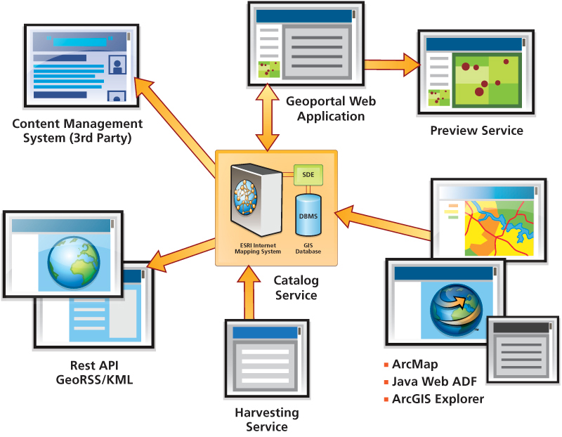
Recent years have witnessed the rapid advance and expanding use of automated mapping, GIS, and spatial data communication technologies. Such progress—along with the associated growth in geospatial data collection activity by organizations and governments throughout the world—has helped create a global reservoir of electronically enabled geospatial information that has a real potential for improving decision making and operations at all levels of endeavor in all types of organizations. For this potential to be fully realized, geospatial information resources must be positioned both institutionally and technologically for discovery, exchange, and use. A spatial data infrastructure (SDI) has evolved as a conceptual framework to enable geospatial information sharing at a significant scale. The ArcGIS Server Geoportal extension provides a technical mechanism—a GIS portal or geoportal—for posting, discovering, and exchanging existing geospatial resources in support of both broadly based SDIs and more narrowly framed local and organization–specific data–sharing communities. Geoportals reduce the time users spend finding relevant geospatial resources that meet their needs and help ensure that they only use approved, high–quality datasets. Capabilities of the ArcGIS Server Geoportal ExtensionThe ArcGIS Server Geoportal extension gives organizations the capability to organize and publish the location and descriptions of their geospatial resources and gives users the ability to discover and connect to these resources. Metadata is the information that describes the content, quality, condition, origin, and other characteristics of a resource. Metadata for geospatial resources typically documents how, when, where, and by whom the data was collected; the availability and distribution information; its projection, scale, resolution, and accuracy; and its reliability compared to established standards. The ArcGIS Server Geoportal extension collects and publishes metadata in a central catalog that allows users to search and access the associated resources. It does not create or duplicate geospatial resources but allows organizations to leverage existing resources regardless of their location, format, or structure. It encourages collaboration and cooperation among multiple departments and organizations by facilitating sharing of geospatial resources regardless of GIS platform. It also gives organizations an enterprise–level awareness of disparate geospatial resources and activities. The ArcGIS Server Geoportal extension addresses the needs of four very different constituencies:
The ArcGIS Server Geoportal extension provides powerful, intuitive tools and features to make it easy for everyone to develop, administer, and use geoportals. Developing GeoportalsTo help portal developers get a geoportal up and running quickly, the ArcGIS Server Geoportal extension includes an out–of–the–box portal application. This application gives users a fully functional metadata catalog to search and publish resources and uses the ArcGIS API for JavaScript to preview resources. The out–of–the–box application is simple to customize, with documentation included that demonstrates how to modify every component of the application. The extension also includes a REST API that portal developers can use to integrate GIS geoportals into their external Web applications. The REST API supports GeoRSS, KML, and HTML outputs, which allows developers to include dynamic portal feeds in other applications. For example, a GeoRSS feed could be used to notify portal users, in real time, about updates to the geoportal. Administering GeoportalsThe ArcGIS Server Geoportal extension integrates well with enterprise architectures because it is built on service–oriented architecture (SOA) principles, supporting existing IT, Web, and geospatial interoperability standards, including industry specifications of the Open Geospatial Consortium, Inc. (OGC). The ArcGIS Server Geoportal extension includes enhanced security features. It supports user authentication with an external authentication service through the LDAP. This protocol is available on most user directories, including, but not limited to, Microsoft Active Directory, Sun Open Directory Server, Oracle CoreID, and IBM Lotus Domino. Sensitive data can remain behind the firewall, and access can be restricted to authorized employees and business units. Organizations can control record–level metadata access through the use of three types of access control policies. The Unrestricted policy allows all users to access all approved resource descriptions. The Public–Protected policy allows all users to access public documents and only allows members of one specific group to see the protected documents. Finally, the Restricted policy allows all users to access the unrestricted documents, but only specified groups have access to restricted documents. During the aftermath of Hurricane Katrina, particular datasets were made available to first responders for a brief period of time without making these datasets publicly available. The ArcGIS Server Geoportal extension also includes a harvesting tool that allows portal administrators to add and update large volumes of geospatial resources to the metadata catalog. The harvesting tool automatically retrieves and updates metadata from existing catalogs and databases, then registers them with the metadata catalog. Publishing and SharingThe ArcGIS Server Geoportal extension supports many different metadata profiles and standards. In addition to a custom metadata service based on ArcGIS Server technology, the extension supports Dublin Core, Federal Geographic Data Committee (FGDC), and International Organization for Standardization (ISO) metadata standards. Organizations or SDI initiatives typically create profiles of these standards to capture specific or additional information in resource descriptions that are deemed relevant for the particular SDI initiative. To support two globally relevant SDI initiatives, the ArcGIS Server Geoportal extension includes support for the North American Profile and INSPIRE profile of the ISO metadata standards. The browser–based Web application allows resource publishers to register their resources with a geoportal and either create the metadata directly or upload existing metadata. The Web application also provides tools for managing published resources. Additionally, resources can be published directly to a geoportal from ArcCatalog by using the publishing client. Discovering and Using GIS ResourcesThe browser–based Web application created by the portal developers and managed by the portal administrators provides an intuitive experience for resource users to find, preview, and access geospatial resources. Additionally, they can search and access resources directly from ArcGIS Desktop and ArcGIS Explorer with the freely available CSW clients, which integrate seamlessly with these desktop GIS programs. Additionally, to save time and IT resources, users do not have to access or download an entire resource to use it in their projects. By using the clip–zip–ship task, users can draw a polygon around their desired location, select the layers they wish to receive from that location, and choose an output format and projection. The geoportal, using the ArcGIS Server Data Interoperability extension, runs a geoprocessing task that extracts the required information from the resource and sends the user an e–mail with the location of the extracted data. ConclusionOrganizations use the ArcGIS Server Geoportal extension to improve knowledge sharing, reduce duplication of effort, direct people toward the best available data, and improve the overall quality of geospatial data and information. With the ArcGIS Server Geoportal extension, organizations improve the efficiency and effectiveness of More InformationTo learn more about the ArcGIS Server Geoportal extension, visit www.esri.com/gisportal. See also the article on "GEOSS GEO Portal". See also "ArcGIS Server OGC News Update." |