Summer 2009
Summer 2009 |
|||||||
|
|
|||||||
Mobile GIS Aids Victoria Bushfires Search Operations |
|||||||||
Highlights
February 7, 2009, will forever be remembered as "Black Saturday," the day of Australia's deadliest natural disaster. Multiple days of temperatures above 41�C (106�F) combined with low humidity, 13 years of drought, and northerly 100 kilometers/hour winds to create an alignment of forces that produced extreme bushfire conditions that far exceeded the maximum fire danger ever recorded. Melbourne, Australia, recorded its hottest day ever, a blistering 48�C (118�F). Dozens of fires erupted across Victoria; the speed of the fires preempted the usually well-organized evacuations of those who decided to leave early. Several large conflagrations merged, forming the Kinglake Complex. Hundreds of residents who stayed to defend their homes, or who waited too long to evacuate, perished within the first 10 hours. After the flaming front passed through developed, inhabited areas, the Victoria Police (VicPol) assessed the damage and number of fatalities. Entire towns and communities ceased to exist. Familiar landmarks, such as street signs, mailboxes, residences, and businesses, were reduced to smoldering rubble. The number of missing or unaccounted-for individuals continued to increase, along with the growing numbers of deaths during this unprecedented catastrophe covering more than 220,000 hectares. This prompted the use of geospatial technologies and real-time mobile GIS to determine the extent of the devastation and to document the location of human remains. It was determined early during the search that additional specialist resources would be needed. A call was placed to the Australian Capital Territory Emergency Services Agency, which deployed its newly formed Mapping and Planning Support (MAPS) team. This unit, composed of government and private-sector GIS professionals, volunteers its time to respond to disaster management operations. It is the only group in the country organized specifically for this critical function, and this was its first campaign fire assignment. MAPS arrived on scene with laptops loaded with ArcGIS software and wireless communication modems. Each team had a lead GIS specialist and five to seven GIS technicians. They worked 12- to 18-hour shifts for five days, then would be replaced by another team. One day of overlap was scheduled to ensure consistency during the transition. The MAPS team achieved impressive statistics while assisting VicPol for 43 days:
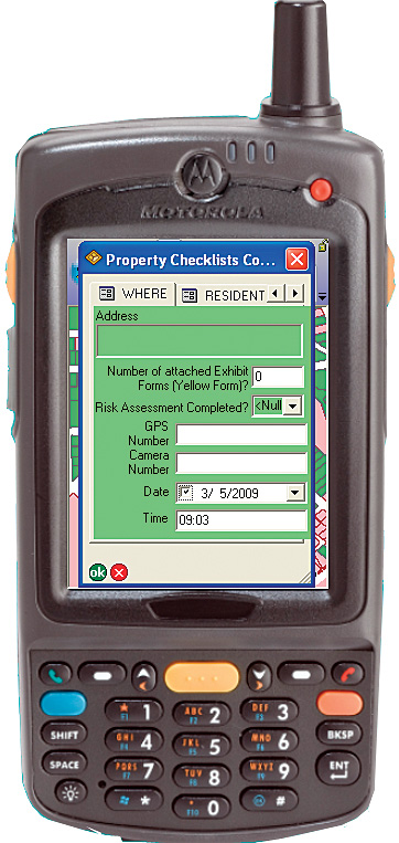
Rugged PDAs running ArcPad 8 mobile GIS software were obtained from Esri Business Partners Trimble Navigation and Motorola by Esri developer Maptel. Maptel programmers worked tirelessly for extended hours to quickly develop an ArcPad custom applet that could be used for damage assessment. This applet displayed the same Rapid Impact Assessment (Premises) form commonly used by VicPol but in a digitized format automatically linked to parcel data. Further assistance was requested from the public safety division of Esri. The wildland fire specialist responded to work with Victoria Police field teams to deploy mobile GIS data collection units. Additional ArcGIS licenses were provided through Esri Australia Pty. Ltd., Esri's distributor in Australia, as well as Esri's Professional Services staff who installed ArcGIS Server. Esri Australia also arranged for additional computer hardware, including rugged GETAC laptops and notebooks from Toshiba. As often happens in severe fire situations, destroyed communications towers and information technology service outages led to duplication of efforts among the numerous emergency services agencies. Crews worked around the clock to restore utility infrastructure. In mid-February, after additional bodies were found in areas that had previously been searched, the Victoria State Coroner, who is not a medical examiner but a powerful judge, directed Victoria Police to search every property within the Kinglake Complex fire perimeter where anyone could have sought shelter during the fires. This new search, designated Operation Royals, was an enormous undertaking with additional legal documentation requirements. The Australian Defence Force, Australian Federal Police, and Victoria Police provided about 200 personnel, organized into five-person search teams led by a Victoria Police team leader.
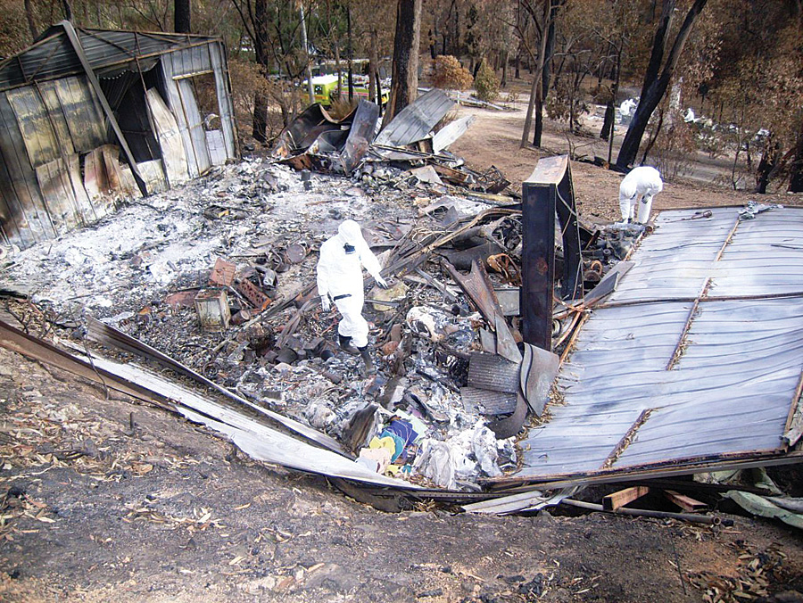
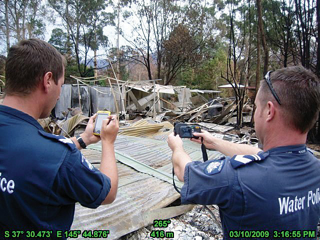
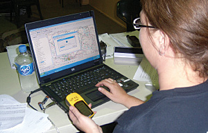
In the high temperatures, the team members were extremely uncomfortable in full protective suits, rubber boots, gloves, helmet, goggles, and a respirator to prevent contact with hazardous chemicals and asbestos. The mandate required the team to inspect each driveway, extending to 50 meters on either side, from the road to the house and 50 meters surrounding the residence and outbuildings. Removal of all fallen materials, including corrugated tin roofing, often necessitated the use of mechanical excavators to enable a comprehensive visual search of the ground for human remains. Before the teams began using ArcPad, the team leader would certify that the property had been properly cleared by filling out a paper form that was color coded: green for residences and yellow for outbuildings, vehicles, tanks, mine shafts, drainages, etc.—anywhere someone could possibly hide to escape the inferno. Occasionally, the form was incomplete or inaccurate, and the property would have to be searched again. The final task required that a green tag be placed in plain view, indicating the property had been thoroughly searched, or a red tag if possible remains were discovered. Disaster victim identification teams would confirm if the remains were human or animal. Team members used GPS and NAVTEQ street map data extensively for navigating to assignments. They used Ricoh GPS-enabled digital cameras to record findings and document photos. Each night a person from the Rescue Coordination Center would drive the 150-kilometer round-trip to the incident command post in Kinglake to retrieve all the forms and swap the secure digital storage cards in each camera. Information was manually typed into the database from the forms; updated tactical maps showed which areas had been adequately searched. It took a couple of days for Maptel to develop a completely new ArcPad 8 applet that was password protected and reflected the additional search criteria ordered by the coroner. Officers trained in its use conducted field tests in parallel with the ongoing "analog search." The officers commented favorably on how much time the ArcPad applet saved them; by just tapping on the screen, they could select items from the drop-down menus. These were some of the same team leaders who had previously used paper forms and had limited or no prior GIS experience. They were extremely pleased to see the green- or yellow-colored indicators that had identical information as the paper forms. The built-in GPS would place them in the correct parcel, and the applet would not allow them to advance to the next screen unless all the required information had been entered, thereby ensuring complete and accurate information was recorded. The officers quickly adapted to this new technology, and even the ones who were reluctant to learn a new way to collect the data admitted it was much faster getting updated tactical maps once ArcPad was deployed. There were no more 48-hour delays or duplication to determine where to look next. The reports were accurate with no omissions, and there was no need to go back to the same property to look again. The collected information was easily integrated into the existing VicPol Web mapping site via a Web Map Server feed as soon as the mobile devices synchronized with ArcGIS Server in the Rescue Coordination Center through the Telstra 3G cellular network. Any authorized search manager could instantly tell by a quick glance which areas were cleared and where to concentrate resources for the next shift. By the time Operation Royals came to an end, the teams used ArcPad exclusively to document the search progress.
Sergeant Greg Barras, situation unit leader, states, "By the time we developed the handheld mobile solution, QA'd the process, and trained our operators, we achieved the following: there were 5,781 total properties searched; 3,352 separate location searches conducted on buildings, sheds, vehicles, and water tanks; 9,600 photos taken using georeferenced cameras; and 1,539 records collected using ArcPad 8 and transmitted via the 3G cellular network to the server at the Rescue Coordination Center without any issues. I would argue that to acquire equipment, develop a system and process, get approval, train operatives, and successfully collect real-time data in less than three weeks is a mighty effort. Especially since we have not been able to achieve this over the last eight years for a raft of different reasons." More InformationFor more information, contact acting sergeant Greg Barras, Victoria Police (e-mail: gregory.barras@police.vic.gov.au). |