Australia Develops a National Groundwater Information System
Highlights
- The NGIS is designed on the ArcGIS geodatabase.
- The Arc Hydro Groundwater data model, with custom modification, is the base of the NGIS design.
- Available tools allow visualization and analysis of groundwater data in ArcGIS.
Management of water resources has become a major effort for governments around the world. As populations grow, the need for water for domestic, industrial, and agricultural uses increases, while resources are diminishing due to overuse and contamination. In Australia, almost 10 years of drought has emphasized the need for better management of water resources. In 2004, at the Council of Australian Governments, an intergovernmental agreement on a National Water Initiative (NWI) was signed. The NWI is Australia's enduring blueprint for water reform. By adopting the NWI, the governments of Australia have agreed to develop a more cohesive national approach to manage water resources across the nation.
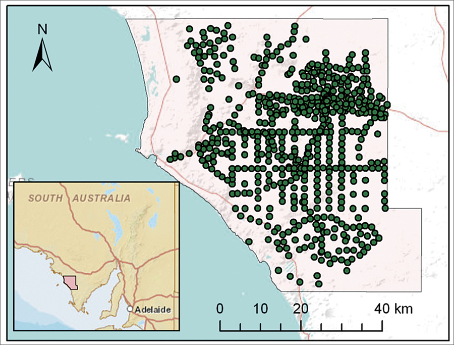
Example of an implementation of the NGIS for the Musgrave prescribed well area in South Australia.
The NWI plan has acknowledged the importance of managing groundwater and surface water conjunctively as a whole water cycle, including a number of areas where development of knowledge, plans, and information systems is required. These areas include
- Increased knowledge of groundwater-surface water connectivity
- Return of over-allocated or overused systems to environmentally sustainable levels of extraction
- Better understanding of sustainable extraction rates and the relationships between groundwater resources and groundwater-dependent ecosystems
To support these requirements, the need to design better information systems as the basis for development of better knowledge and planning was acknowledged. In response, a National Groundwater Data and Information Systems workshop was held in Melbourne in December 2008. One of the outcomes of this workshop was the conception of a National Groundwater Information System (NGIS).
Traditionally, in Australia (like many other countries), groundwater information is collected and managed by local jurisdictions. This creates challenges (including technical and legal) on how to incorporate cross-border information in regional and national projects. Some of the goals identified for the NGIS project are focused on overcoming these challenges. These include the development of a national aquifer framework and naming convention and incorporation of jurisdictional data that supports approval, licensing, and data collection for bores.
The Water Division of the Australia Bureau of Meteorology (BoM) took the lead role in managing the NGIS project. From a technical perspective, spatial objects (e.g., aquifer surfaces, aquifer boundaries, borehole locations, and groundwater management units) were recognized to be integral parts of the NGIS. The ArcGIS geodatabase was selected as the core RDBMS system on which the NGIS system would be designed, as this would enable the system to store spatial and tabular information together and display the information using standard ArcGIS applications (ArcMap, ArcScene, and ArcGlobe). The ArcGIS platform was also chosen due to BoM's long-term experience with ArcGIS, including geodatabase design, and the wide use of ArcGIS by anticipated users of the NGIS at BoM and other government agencies.
BoM, together with consulting companies Sinclair Knight Merz of Melbourne, Australia, and Continuum Consulting of Melbourne, Australia, embarked on the design of a prototype for the NGIS. During the development of the prototype, the group selected the Arc Hydro Groundwater data model as the base for the NGIS design. The project benefited from deployment of a relatively mature and publicly available design, which was suitable for use with Esri products (the Arc Hydro Groundwater data model is publicly available and documented in Arc Hydro Groundwater: GIS for Hydrogeology [Esri Press 2011]). The Arc Hydro Groundwater design was leveraged where suitable, and additional extensions and modifications were incorporated for meeting key NGIS functional requirements. A stepwise approach was taken in the design and implementation of the NGIS. Initially, a core geodatabase focusing on representing boreholes and borehole-related data was designed in detail. This core data model serves as a starting point for implementation. A more complete vision for the geodatabase was also outlined to represent a wide array of datasets required for groundwater analysis, including aquifer units, time series, licensing, and surface water-groundwater interaction.
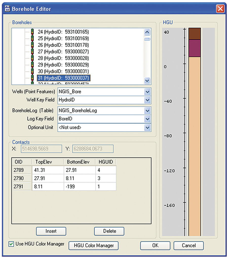
Borehole data can be visualized and classified within ArcGIS using a borehole editor that is part of the Arc Hydro Groundwater tools.
The core geodatabase design focuses on representing boreholes and related vertical information, such as borehole stratigraphy and well construction. The geodatabase includes a borehole point feature class representing the locations and attributes of bores. Vertical information (lithology, hydrostratigraphy, and well construction) is stored in tabular format, where there is a separate table for each type of vertical information. The tabular information includes attributes for storing top and bottom elevations for each segment along the bore. These can be stored as depths along the borehole or as absolute (e.g., meters above mean sea level) top and bottom elevations. In addition, the core design includes 3D line feature classes, which enable visualizing the vertical information in ArcScene or ArcGlobe.
For the implementation, BoM selected the Arc Hydro Groundwater toolset developed by Esri Partner Aquaveo, LLC, of Provo, Utah. The tools enable users to prepare 2D and 3D visualizations of groundwater information, including the creation of water-level and water-quality maps, sketching of geologic and hydrogeologic cross sections, and development of 3D subsurface models. A set of case studies was prepared for testing the core data model with real data, and these examples were also used in a set of training classes that helped BoM and the jurisdictions staff with implementing the NGIS data model. The data used in the examples is from the Musgrave prescribed well area (an administrative area for management of groundwater) in South Australia and includes visualization and classification of borehole data in ArcGIS, creation of 3D visualizations of borehole stratigraphy and water-level and water-quality maps, and animation of changes over time.
For more information about the NGIS project, contact Alys Wall, NGIS project manager, Australia Bureau of Meteorology (e-mail: a.wall@bom.gov.au). For more information on the Arc Hydro Groundwater data model and tools, visit www.aquaveo.com/archydro or contact Gil Strassberg (e-mail: gstrassberg@aquaveo.com) or Norm Jones (e-mail: njones@aquaveo.com) of Aquaveo, LLC. To download the Arc Hydro Groundwater Data Model, visit resources.arcgis.com/content/groundwater-data-model.