From Maps to GeoDesign
Conserving Great Ape Landscapes in Africa
By Lilian Pintea, Africa Programs, The Jane Goodall Institute
![]() The Jane Goodall Institute (JGI) has been very interested in the evolution of the new field of GeoDesign, which offers the vision and the infrastructure to bring people, disciplines, data, and technology together to not only better describe landscapes but also develop more successful conservation strategies and actions.
The Jane Goodall Institute (JGI) has been very interested in the evolution of the new field of GeoDesign, which offers the vision and the infrastructure to bring people, disciplines, data, and technology together to not only better describe landscapes but also develop more successful conservation strategies and actions.
One practical application of GeoDesign has been the successful use of geospatial and conservation sciences to inform decisions in the Greater Gombe Ecosystem in Tanzania. JGI greatly improved village land use in this very sociopolitically difficult and historic setting. We were successful not only because of the technology we employed but also because the JGI staff understood human values and decision-making processes that influence landscape change in that particular region. We learned that helping develop the region (e.g., through working together to provide clean water sources, among many projects) opened the door to communities and motivated them to "buy in" to our efforts, creating a window of opportunity to apply conservation science to threatened ecological systems. Some of these programs are discussed in detail below.
At the core of JGI's applied conservation science program is using geography as a common framework to support our projects in Africa by connecting people, their values and activities, and conservation data and developing a shared understanding and vision of landscapes and how they should be changed. This in turn enables us to implement, monitor, and measure the success of those changes for both human and chimpanzee livelihoods.
We Need to Make More Enlightened Decisions

Jane Goodall with Freud (courtesy The Jane Goodall Institute).
Time is running out for many endangered species, including our closest living relatives, chimpanzees. Chimpanzee and human populations are part of the same life support system, embedded in ecological systems that are intimately linked and dependent upon ecosystem services to survive. Unsustainable uses of natural resources by humans result in loss of those ecosystem services, with negative consequences for both chimpanzee and human livelihoods. The fundamental problem is that, despite advances in science and technology, we have not yet developed the methodologies to apply these to conservation and make more enlightened decisions about how to achieve a better balance between environmental and economic results.
Fifty years ago, on July 14, 1960, Jane Goodall stepped for the first time onto the shores of Lake Tanganyika and, through her groundbreaking discoveries about chimpanzees in what is now Gombe National Park in Tanzania, opened a new window to the natural world and to ourselves. This unique long-term research continues today with daily chimpanzee data collected by the JGI Gombe Stream Research Center and digitized, stored, and analyzed at the Jane Goodall Center at Duke University.
GIS and Imagery for Clearer Understanding
GIS has been used to georeference and digitize hundreds of thousands of chimpanzee behavior locations and analyze ranging and feeding patterns and relations with habitat characteristics as detected by remote-sensing and field surveys. The use of geospatial data for chimpanzee research was straightforward. Spatial tools and variables derived from GIS and remote sensing were directly used as part of research collaborations to test hypotheses. For example, a vegetation map derived from 4-meter IKONOS imagery helped demonstrate that chimpanzee hunts on colobus monkeys are more likely to occur and succeed in woodland and semideciduous forest than in evergreen forest, emphasizing the importance of visibility and prey mobility. JGI also worked with the Tanzania National Parks to improve the management of the park by using geospatial technology to visualize habitat change, map the park boundary, and support the development of the Gombe National Park Management Plan.
In addition to continuing Jane Goodall's pioneering research, JGI has been accumulating decades of experience and practical knowledge outside protected areas on how to successfully engage local communities and decision makers in the sustainable use of their natural resources. While the technology to map land cover inside and outside Gombe National Park was mostly the same, the way geospatial information was used to inform decisions was very different.
The use of geospatial information to inform decisions outside the park has been more complex. Gombe National Park was created in 1968. The park inherited a history of conflict with the local communities that started in 1943 when the colonial government established for the first time Gombe Stream Game Reserve. In 1994, JGI began working with the local communities outside Gombe through the Lake Tanganyika Catchment Reforestation and Education (TACARE, pronounced "take care") project to seek ways of arresting the rapid degradation of natural resources. TACARE project staff quickly learned that community buy-in was essential for success. Therefore, the TACARE project added agriculture, health, social infrastructure, community development, and clean water components to the range of interventions it employed. These interventions initially focused mostly on areas close to village centers.
Participatory village land-use plans were prepared by the communities according to Tanzanian laws (courtesy The Jane Goodall Institute).
However, forest change detection using Landsat imagery from 1972 and 1999 showed that most chimpanzee habitats outside the park had been in areas away from the village centers and almost 80 percent of it converted to farmland and oil palm plantations. Remote-sensing and GIS analysis led to a landscape approach by focusing conservation efforts geographically on areas away from village centers and on forest patches with the most benefits to chimpanzees. In 2005, adopting the recommendations obtained through analysis of satellite imagery and with funds from the US Agency for International Development (USAID) and other donors, JGI and its partners embarked on a five-year Greater Gombe Ecosystem (GGE) project.
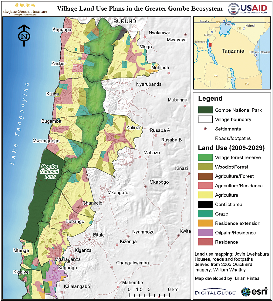
A Conservation Action Plan approach was developed to identify and prioritize conservation strategies. Village land-use planning was identified as one of the top strategies. GIS was used to overlay deforestation layers, historic distribution of chimpanzees and habitats, slope, footpaths, roads, streams, watersheds, density of human structures, and 60-centimeter QuickBird imagery to prioritize a conservation area that, if protected, would substantially increase the viability of chimpanzees inside and outside the park and stabilize the watersheds to support human livelihoods.
Participatory village land-use plans were prepared by the communities according to Tanzanian laws and with full involvement of government and community stakeholders. JGI facilitated the process and provided technical support, including maps and geospatial tools to record and manage spatial data. The planning process followed seven steps and required villagers to settle any existing land disagreements and agree on village boundaries and how land resources located within the villages should be used to meet specific human livelihood needs and environmental objectives.
At the end of the project in 2009, 13 villages within GGE completed their participatory village land-use plans, which became ratified by the Tanzanian government. Local communities voluntarily assigned 9,690 hectares, or 26 percent, of their village lands as Village Forest Reserves. These reserves are interconnected across village boundaries to minimize fragmentation and cover 68 percent of the priority conservation area identified by the GGE Conservation Action Plan.
With renewed financial support from USAID, JGI and partners are now engaged in facilitating community-based organizations, developing bylaws and building local capacity to implement these village land-use plans and restore and manage newly established Village Forest Reserves. The plan is to use DigitalGlobe imagery continuously to provide detailed information on village land-cover change, such as increases in forest cover in Kigalye Village Forest Reserve, and monitor both new threats and conservation successes.
About the Author
Dr. Lilian Pintea brings more than 15 years of experience in applying remote sensing and GIS to the job of protecting chimpanzees and their vanishing habitats in Africa. As vice president of conservation science at JGI, Pintea directs the scientific department at the institute and conducts applied conservation research in Tanzania, Uganda, the Democratic Republic of the Congo, and the Republic of the Congo.
For more information, contact Lilian Pintea (e-mail: lpintea@janegoodall.org).
See also "Harnessing the Power of Our GeoDesign Vision."