Korea's Forest Service SDI
Highlights
- ArcGIS Server achieves optimum functionality for searching appropriate space structure for data extraction.
- Forest landowners and the public can easily search for forestland information.
- The web-based system allows foresters to improve conservation efforts, as well as increase profit and quality of public service.
Korea Forest Service (KFS) specializes in planting and taking care of forests. It aims to build a sustainable green welfare nation with a mission to promote healthy forests, rich mountains, and a happy populace. To satisfy this vision, KFS is making an effort to further encourage and strengthen the forest sector at the domestic level and act as a global green leader based on successful experiences in forest rehabilitation at the international level. KFS plans to reinforce carbon cycle economy, improve the quality of green life, conserve and manage green resources, and become a global green leader.
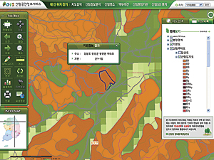
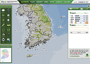
KFS created a website, the Forest Spatial Data Information (FSDI) portal, which is used in forestland administration. The FSDI portal provides forestland and national property management, including map and data distribution services and a forestland thematic map. Customers and the nation demanded accurate forestland information that they could access quickly. The Forest Spatial Data Information portal provides detailed information to help users find specific mountains; search maps; and analyze forestland information, land statistics, and attraction information.
Korea Forest Service applied ArcGIS API for JavaScript with ArcGIS Server caching to enable quick loading of massive amounts of data. The portal also improved the safety and function of data with an enterprise-based ArcGIS Server dispersion structure. This system supports optimum functionality for searching appropriate space structure for data extraction, as well as copying and querying the geodatabase.
Adopting a web-based system made it easy to check related attribute information for forestland thematic maps, as well as obtain data from various sources through online requests. Additionally, the organization was able to reduce the license management cost and manage the data more safely and efficiently.
With easy access to the web-based system, KFS can handle its official business in a more accurate and efficient way, and forest owners and the public are now able to check their own lands' information on the web and utilize the system for forest management. Foresters can realize increased profit by inquiring about related data. The public has gained access to data it has a right to know, and the policies of the forest industry can be better implemented. What is more, this web system has an ability to increase the quality of public services; by providing many kinds of information to 2.1 million forest landowners, the web portal has made it simple to conserve the environment and manage environmental resources.
The FSDI portal provides various kinds of information related to location, including attribute data that will be inputted and analyzed with computers and used by planners and decision makers. The data can be integrated with software, hardware, and human resources.
This system has enhanced functionality in three ways. It improved service management by reducing the data migration and maintenance burden on human resources by about 30 percent. It maximizes data value by enhancing productivity, creating the forestland information as data. Last, the web service decreases the time required between investigation and permission from 15 days to two hours.
The portal saved 200 million KRW (US$175,500) and about 12,000 worker hours in 2009. Korea Forest Service has plans to expand this GIS service in 2012 to provide forestland information for mobile services through iOS and Android.
For more information, visit fgis.forest.go.kr/fgis.

