Cultural Heritage Management and GIS in Petra, Jordan
Geospatial Technology Drives Research
By Thomas R. Paradise, Department of Geosciences, University of Arkansas, and Douglas C. Comer, Principal, Cultural Site Research and Management
Highlights
- Researchers use satellite data to build a GIS database for research and management.
- Mapping in ArcGIS reveals rapid pace of deterioration from weathering and erosion.
- Data informs plans for mitigating the effects of rain runoff and tourism in the area.
![]() The now-ruined city of Petra lies hidden in a deep valley surrounded by steep, eroded sandstone walls and winding earthquake-created gorges in the arid expanse of Jordan's great southern desert. However, it is the allure of Petra's mesmerizing rock-hewn architecture rather than its beautiful geologic setting that primarily draws tourists to the area. The brilliant craftsmanship and urban planning of Arab Nabataeans two millennia ago ensured the city's place in history. Those Nabataeans carved elaborate structures directly into the towering reddish-brown cliffs and ingeniously harvested meager rainfall to create fountains and water pleasure gardens under a sun hardly ever hidden by clouds.
The now-ruined city of Petra lies hidden in a deep valley surrounded by steep, eroded sandstone walls and winding earthquake-created gorges in the arid expanse of Jordan's great southern desert. However, it is the allure of Petra's mesmerizing rock-hewn architecture rather than its beautiful geologic setting that primarily draws tourists to the area. The brilliant craftsmanship and urban planning of Arab Nabataeans two millennia ago ensured the city's place in history. Those Nabataeans carved elaborate structures directly into the towering reddish-brown cliffs and ingeniously harvested meager rainfall to create fountains and water pleasure gardens under a sun hardly ever hidden by clouds.
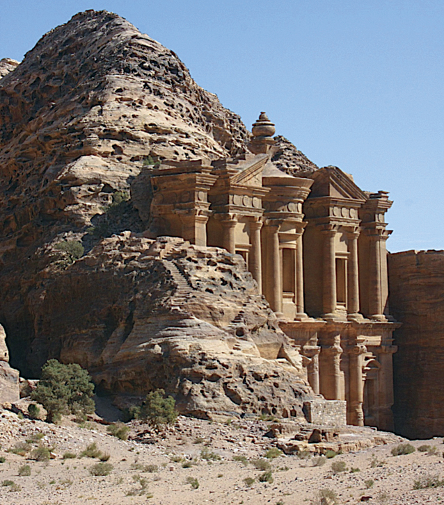
Ad-Deir, or the Monastery, high above the valley—one of the largest of the hewn structures in Petra. (Photo courtesy of Thomas Paradise)
Twenty years ago, Cultural Site Research and Management (CSRM) and the University of Arkansas Department of Geosciences embarked on a project to begin understanding the accumulating effects of nature and foot traffic at Petra. Over time, researchers constructed a sophisticated system for managing, accessing, and analyzing aerial and satellite views of Petra. Through that research, the teams learned that human influence and meager rainfall have greatly increased Petra's physical decline. Remote-sensing imagery and geospatial technology have revealed the effects of commercial development and precipitation in Petra, increasing the urgency of conservation efforts there.
Gathering and Processing Imagery
The effort to construct a GIS database for use in research and management in Petra began in 1997 through the Cultural Landscape Analysis Initiative of the United States Committee for the International Council on Monuments and Sites (US/ICOMOS), with the financial support of the Kaplan Fund and software donated by the Esri Conservation Program. Researchers led by professor Talal Akasheh spent two months acquiring on-ground coordinates with early postprocessing GPS equipment. These coordinates were used to rectify synthetic aperture radar imagery developed from data collected by the space shuttle Endeavor, declassified US Corona satellite imagery acquired during the Cold War, SPOT and Landsat imagery, and scanned versions of black-and-white aerial pairs dating to the 1950s provided by the Royal Geographical Society of Jordan. Soon after, GeoEye donated IKONOS four-band satellite imagery, and the National Aeronautics and Space Administration (NASA) provided Advanced Spaceborne Thermal Emission and Reflection Radiometer imagery, which Michael Abrams of the Jet Propulsion Laboratory (JPL)/NASA processed to create a digital elevation model (DEM).
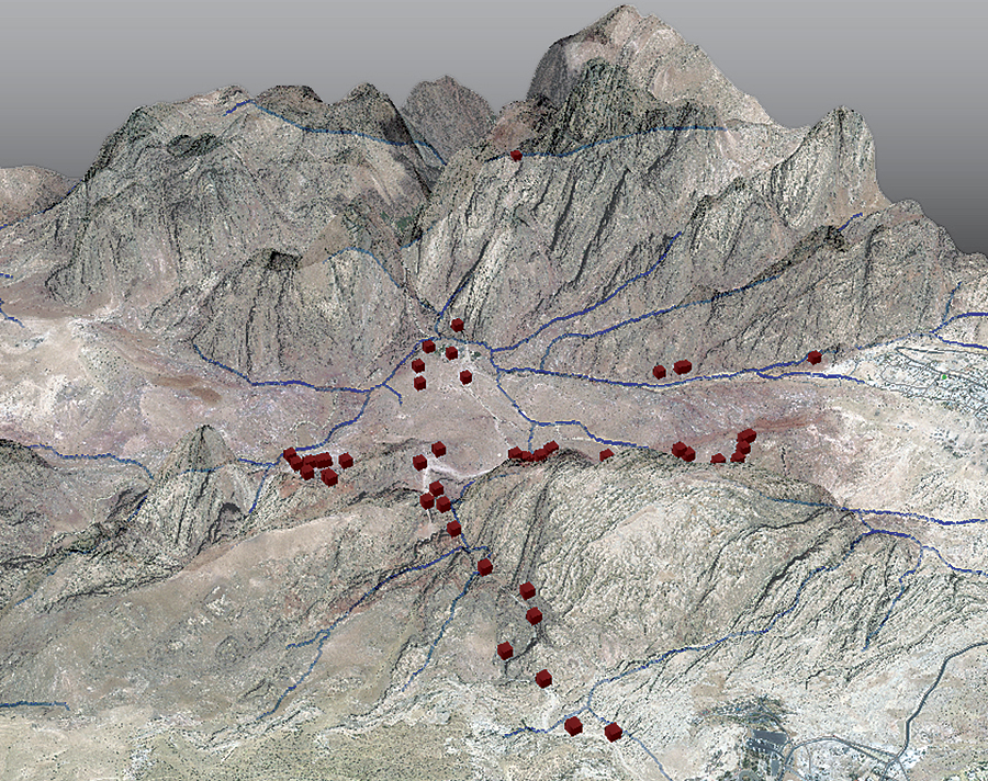
Oblique view of Petra with the Bedouin village of Umm Sayhoun (upper right) and the adjacent city of Wadi Musa (lower right). Blue lines represent ephemeral watercourses (wadis), and red cubes represent GPS markers at primary tomb facades. The map was created by Christopher C. Angel in ArcGIS (2012).
That gold mine of satellite and DEM data formed the backbone of a dynamic and ongoing GIS program in Petra, the Petra GIS Project, which explores technology for the furtherance of preservation research at Petra. Powered by ArcGIS and the cooperation and collaboration of many organizations, the project has contributed greatly to the understanding of this fabled city. Petra's GIS functions as a model of the archaeological landscape. Beyond its conservational purpose, it aims to help researchers answer important archaeological questions, such as why the nomadic Nabataeans, who had amassed great wealth by controlling the trade in precious goods over the vast desert, decided to settle in the area and build one of the most spectacular cities of the ancient world. Because of its historical and cultural significance, the model is currently being developed and applied by CSRM and a research team from the University of Arkansas Department of Geosciences to explain why the millennia-old monuments in Petra have drastically deteriorated in recent years.
GIS for Interpretation and Preservation
Field studies in Petra conducted by the University of Arkansas's Department of Geosciences over two decades originally included the assessment of sandstone weathering across Petra at Al-Khazneh (the Treasury), the "theater," Urn Tomb, and various tombs and facades. New studies have attempted to link the various aspects of this diverse landscape and have included physical components, like fungus identification, measurement, and mapping, and the assessment of climatic influences, such as rainfall, on the environment. Researchers used ArcGIS to analyze the imagery data of the Petra landscape in ways that highlighted changes in regional hydrology produced by tourism development in nearby communities. Analysis revealed that these changes have vastly increased the pace of structural deterioration at Petra. Specifically, the construction of roads, hotels, restaurants, and other visitor amenities have created impermeable surfaces that prevent the absorption of rain runoff. During rare but intense storms, that water rushes into the canyon where the tombs are located. The water, which contains salt, is absorbed by the porous sandstone, leaving salt crystals in the structure that force sand grains apart. This cyclical process obliterates the delicate tomb facades. Development in Petra has also destroyed ancient Nabataean agricultural terracing and the barrage dams and channels that once directed water to cisterns and reservoirs that were used by the approximately 30,000 people who once inhabited the area.

Petra Archaeological Park management zones in Petra.
Petra's GIS has also played a pivotal role as a database from which to develop management zones, such as those used in urban planning. Management zones specify the appropriate uses and conditions within a given area. GIS also provides the framework for an automated monitoring system that will eventually be used to detect changes in conditions that, left unchecked, would ultimately destroy irreplaceable archaeological remains.
Natural and Anthropogenic Influences
Across Petra, the University of Arkansas research team make use of submeter scales to investigate the effects of microclimatic variations on the development and growth of tafoni (small cave-like features found in granular rock, such as sandstone), honeycomb weathering, and the overall surface recession of Petra's tombs, structures, and monuments. Work at this scale is vital in assisting deterioration research, since weathering has the greatest influence on surface recession and the overall integrity, stability, and condition of the architectural surfaces.
Studies in Petra at the meter-to-decameter level also help researchers examine both natural influences, such as aspect and sunlight effects on recession, and anthropogenic factors. As researchers study more surfaces, monuments, facades, and structures, they spatially correlate their data to weathering features, dimensions, and deterioration rates in ArcGIS. The measurements, mapping, and assessment of these features and surfaces, though typically not thought about as being useful at this scale, increasingly have proved instrumental in evaluating the effects of the anthropogenic and natural influences on large human-made objects from antiquity.
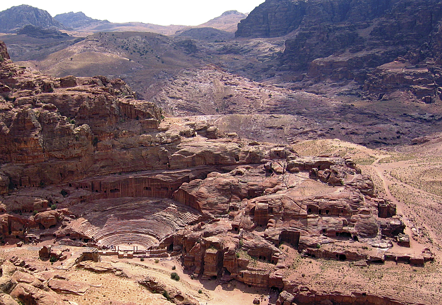
View overlooking the carved theater, and the main roadway into the valley. (Photo courtesy of Thomas Paradise)
Anthropogenic influences, such as surface recession from human contact, are now being assessed, measured, mapped, and linked within GIS. To understand the erosion and weathering of Petra from tourism alone, research teams counted visitors across the valley, noting location, time of day, and number of tourists. They compared those numbers to each day's total visitor numbers and linked them to elevation (isohypsometric) and structure (footprint, planimetric) maps of the valley. After a month of data collection and mapping tourist movement over time and space, they were able to assess who was where, when, and for how long; which paths and corridors they used; previous sites visited; and subsequent destinations and paths each day. These synoptic cartographic methods not only helped the team understand the erosive effects of tourism in Petra but also helped researchers create diurnal visitor movement models.
Spatial Data Networks
The linking of point-specific relationships to integrated spatial and temporal networks has been a crucial advancement in preserving Petra's unique setting and sustaining and protecting its cultural resources. Petra GIS is now working toward the continual development of spatial data networks from various study sites across Petra to create a broader association of factors that influence Petra's physical, cultural, and human landscapes. What began as the modeling and assessment of a sensitive architectural and archaeological site has grown into an extensive arid lands project that links various scales and influences across different sites and elevations using ArcGIS, remote-sensing imagery, and GPS technologies with the goal of better understanding and protecting a truly unique World Heritage site. Only when enough point-based data has been collected site by site, then classified, analyzed, linked, and mapped across the valley, can trends and influences be identified, links understood, and possible causes and effects comprehended. This seems the best approach to understanding desert landscapes and sandstone architecture while effectively managing one million visitors each year.
The next objective of the Petra GIS project is to acquire more lidar data to build an extremely precise surface model that will guide engineering efforts to mitigate the flooding problem at Petra and prevent further deterioration of the tombs. Further research that investigates the natural, anthropogenic, and geospatial influences on architectural decay and environmental degradation in Petra must be done before the effects become irreversible.
About the Authors
Thomas R. Paradise, PhD, professor, Department of Geosciences, and former director of the King Fahd Center for Middle East Studies, University of Arkansas, comes from a diverse background in geography and geology, architectural history, stone conservation, cultural heritage management, Middle East and North Africa geography, and cartography/GIS. His expertise in stone architectural deterioration has been requested by countries across the Mediterranean and Middle East. Douglas C. Comer, PhD, is principal for Cultural Site Research and Management, Inc., president of the CSRM Foundation, and copresident of the ICOMOS International Scientific Committee on Archaeological Heritage Management. He is the recipient of research grants from a number of organizations and agencies and has published widely on the use of aerial and satellite remote-sensing technologies in archaeology and cultural resource management.
For more information, contact Thomas R. Paradise, Department of Geosciences, University of Arkansas (e-mail: trparadise@gmail.com), or Douglas Comer, principal, Cultural Site Research and Management (e-mail: dcomer@culturalsite.com).
Related Podcast
Tourism and GIS Technology
Doug Rosenberg from VResorts.com talks about using interactive mapping for a better vacation experience. Listen to the podcast. [12:00 | 14 MB]