Winter 2003/2004
Winter 2003/2004 |
|||||||
|
|
|||||||
San Diego, California, Firefighters Kept Informed With GIS |
|||||
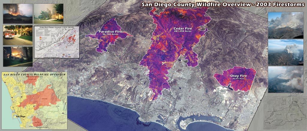
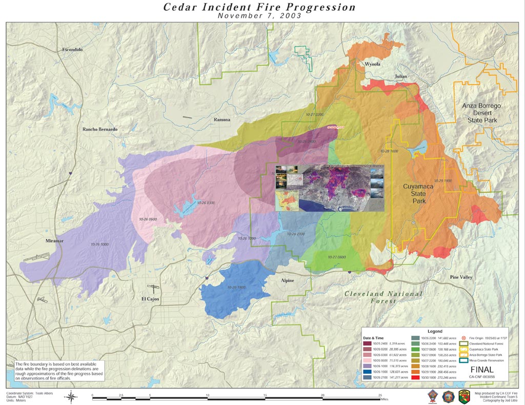
On October 25, 2003, a human-caused fire began near the mountain town of Ramona in San Diego County, California. Fueled by acres of dry brush and fanned by strong Santa Ana winds, the Cedar Fire spread rapidly, consuming more than 140,000 acres in its first day. Containment came 10 days later, only after burning 273,246 acres, destroying 2,232 homes, and killing 14 people. The speed and ferocity of the blaze were heart stopping, and keeping the more than 6,000 firefighters battling the flames informed was a massive undertaking. GIS on the SceneAs the Cedar Fire grew, the California Department of Forestry and Fire Protection (CDF) contacted NorthTree Fire International (NTFI), a fire response GIS contractor based in Monterey, California. Successful fire operations depend on obtaining information about the location of the fire perimeter, establishing priorities, and implementing an incident action plan—all activities that benefit from GIS. Outfitted with a plotter, numerous PCs, and a formidable array of Esri GIS software, NTFI's GIS trailer and staff journeyed to San Diego to support the CDF GIS team members. Upon its arrival, the trailer became a round-the-clock nerve center, providing firefighters and decision makers with the most accurate and up-to-date maps and analysis. With ArcView, ArcInfo, ArcGrid, ArcGIS 3D Analyst, ArcGIS Spatial Analyst, and ArcPress for ArcGIS, as well as Acrobat, Adobe Illustrator, and Photoshop at their disposal, GIS team members produced hundreds of detailed maps integrating multiple information sources from field observations and infrared helicopter data. "The most critical maps we generated were those for the morning briefings, and they had to be done by that time," says Colby Barr, GIS mapping specialist, NTFI. "There is no way you tell thousands of firefighters, 'I'm sorry I don't have the information you need.' These maps are a necessity. They use them to be aware of their surroundings and the larger context of the fire, to strategize for the day."
At these morning briefings, firefighters were shown full-size plots with the progression of the fire, where the fire was active or contained, bulldozer lines, and other critical data such as supply drop points and water sources. These maps detailed which section of the fire line each division was responsible for and were supported by more detailed 11" x 17" map packets handed out to division group supervisors, branch directors, and strike team leaders. On these sheets, firefighters charted their assignments for the day, utilizing the information on roads, buildings, water sources, drop points, and staging areas contained within. Creating numerous informational resources for managing the fire, GIS team members enabled decision makers to plan effectively in their allocation of hand crews, bulldozers, engines, aircraft, and other assets. "If we didn't have these maps, the firefighters wouldn't have known where to go, how to get there, or what their assignments were," says Jeff Harter, situation unit leader, CDF. "Using GIS we could pull all of the necessary information and help them make their plans of attack. It is amazing how much difference it makes to have good quality maps that are easy to understand and tell a story." Local Groups Give Insight, ExpertiseCDF and NTFI were not working alone. GIS professionals throughout the area converged to help, working around the clock, their own homes at risk from the devastating blaze. Numerous local agencies donated time and resources including Esri, County of San Diego, Hewlett–Packard, San Diego Association of Governments, San Diego Geographic Information Source, Space Imaging, and U.S. Forest Service. "The outpouring of support and the overwhelming cooperation between the public and private sectors was incredible," says Harter. "We didn't have to ask them, they came to us. Software, hardware, and data providers contacted us immediately and offered us any type of assistance we needed. This helped us tremendously. We wouldn't have been able to do all the mapping we needed without this." "We all brought something different to the table," says Tim Craig, regional account manager, Esri, San Diego. "We were able to use our various strengths, knowledge of the software, and knowledge of the area's data sets to get firefighters the information they needed. This was a great example of bringing local resources to bear on a regional emergency. Having the knowledge of locals was often an asset when adding details to maps and identifying particular locations. I think all the agencies involved, and those that weren't as well, can learn from this and work to get relationships built before an emergency happens, so that if/when an event happens again, the local, state, and federal groups can work together even better, and even sooner." For more information, contact Jeff Harter, battalion chief, California Fire Plan, California Department of Forestry (tel.: 916-327-4983, e-mail: jeff.harter@fire.ca.gov). |