Digital Mapping: The Next Generation
Georgia's Coastline Benefits from Lidar-Created DEMs
Highlights
- Using lidar data, water flow can be simulated in ArcGIS based on elevation.
- Planners and managers build three-dimensional data models of cities and the countryside using the lidar data and GIS.
- Utilities can measure and model water runoff with higher precision, ensuring that the tax rate is equitable.
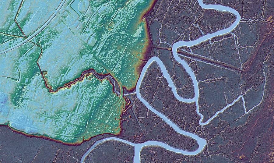
Lidar data showing the City of Darien, McIntosh County, Georgia, with one of many meandering rivers that converge on America's Eastern Seaboard.
The State of Georgia's coastline has been experiencing significant population growth over the past few decades, putting increasing pressure on available natural and economic resources. Much of this growth is occurring in low-lying coastal areas that are vulnerable to the effects of tropical cyclones and have limited infrastructure for the booming population. Resources are needed to manage and accommodate this rapid development.
A longtime user of GIS software, the Coastal Regional Commission of Georgia (CRC), under the direction of GIS/IT director Chris Chalmers, MS, GISP, is working with multiple agencies to ensure that geospatial data is created in the area for current community planning and mitigation of any future natural disasters that may affect the area.
CRC encompasses the six coastal counties in Georgia, as well as four inland counties, covering a total land area of more than 5,110 square miles. Meandering rivers flow from low plains to meet the Atlantic Ocean, converging on an area of America's Eastern Seaboard that is a prime destination for those looking for a getaway focused on recreation, culture, or history.
The best data for both planning and disaster management mapping is high-resolution elevation data. Currently, the best available digital elevation data for the entire coastal area of Georgia is from United States Geological Survey (USGS) 30-meter digital elevation models (DEMs). While this data is practical for regional use, more accurately mapped information is necessary for local planning initiatives. Capturing one- to two-foot contours was required to create elevation data suitable for building local datasets that can support such activities as economic planning and infrastructure development and improvements, including transportation, power, water and sewer distribution, land-use planning, and environmental monitoring.
Lidar Acquisition Becomes a Community Effort
To create these contours, CRC formed the Coastal Georgia Elevation Project (CGEP) to invest in light detection and ranging (lidar) technology. Lidar is a remote-sensing technology that measures the time delay between a light pulse transmission and its reception by a sensor. It is represented in its raw data format as a series of x, y, and z points. Highly accurate DEMs can be created within the commission's ArcGIS software from the postprocessed data and used for the mapping needs of the community.
A collection of cities, counties, educational institutions, state and federal agencies, and private-sector organizations within the Georgia coastal county region came together to accomplish this massive task. Chalmers and his team worked diligently, gaining the collaboration of every county within the commission and ensuring that the buy-in was equitable to everyone. "The big question was, how do you break the costs down per county?" says Chalmers. "Some of the smaller counties have greater populations than those with more landmass. These bigger counties will be using more lidar but have less of a tax base to support funding."
The counties finally agreed to fund the project by calculating the cost of the project based on both how much population and how much landmass was contained in each county. CRC secured a grant from USGS through a cooperative agreement to promote the CGEP. At the request of the Georgia Department of Natural Resources Coastal Resources Division, CRC presented the project to the Coastal Advisory Council (CAC), which manages funds for the Georgia Coastal Zone Program. CAC voted to provide a coastal incentive grant to match local funds raised for the CGEP. Additionally, the Georgia Association of Regional Commissions has an enterprise site license for Esri software that provides broader access to GIS technology to members of the state's 12 regional commissions, including CRC. CRC communicates with stakeholders, interested parties, and member governments on the status of the CGEP.
Applications Abound
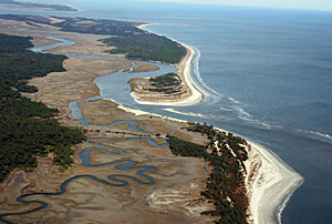
The Georgia coast is approximately 100 miles of open coastal shoreline between the Savannah and St. Marys rivers. (Photo credit: Center for Watershed Protection)
CRC acquired lidar-derived, high-resolution elevation data for the entire coastline of Georgia, from the Atlantic Ocean to 50 miles inland, an area of approximately 4,703 square miles.
"The number one priority for redoing our mapping is to save lives and protect property," says Chalmers.
One of the first applications was redefining the flood boundaries of the area by remapping Federal Emergency Management Agency (FEMA) Digital Flood Insurance Rate Maps (DFIRM). "If we know an area is mapped as a high-risk flood area, and if we know people could be in danger and buildings could be damaged, then it makes sense to take reasonable protective steps when we develop and build," says Chalmers.
Related to this is storm surge, an offshore rise of water that is associated with tropical cyclones, something that is all too common along the Georgia coast. Using the lidar data, the flow of water can be simulated in ArcGIS based on elevation, making it useful data for public safety. "If you can predict where water is going to flow, you become a very powerful building planner," says Chalmers. "Local planners can put buildings where they want them, and with this type of analysis, we can almost guarantee where the water will go."
Building three-dimensional data models of cities and the countryside using the lidar data allows planners and managers to ask many new questions of the data. "If a 20-foot storm surge hits us, we can ask what is the rate, and where? If Interstate 95, which runs along the coast, is going to be underwater according to the model, then we can reroute traffic," Chalmers explains.
Other applications include economic development and more accurate taxation. Effingham County uses the data for tax parcel assessment, particularly to recover monies from untaxed outbuildings. Since lidar shows changes in elevation, the data can be used to assess how many outbuildings are actually on a parcel of land using the line of sight from the horizon.
Measuring impervious surfaces is another way to ensure more accurate taxation. Lidar can help utilities measure and model water runoff with higher precision, ensuring that the tax rate is equitable.
Smart economic development can save the private sector money as well, and in today's economy, helping local businesses is a priority of many governments. "The first thing you have to do when you locate to a community is a survey-it's mandatory," says Chalmers. "If we have this lidar data, this is one thing they don't have to purchase. We can provide this as a free service. This is good for attracting the right businesses into our local communities, as well as ensuring that the development is sound."
Lidar Acquisition Standards
The project is within the 50-mile Atlantic coastal priority area defined by the National Geospatial Program and supports homeland security requirements of the National Geospatial-Intelligence Agency. The CGEP is using the lidar quality guidelines set up by the Florida Division of Emergency Management, since these were developed for the mostly flat terrain that is common to the lower Atlantic coastal plain, including coastal Georgia.
The lidar data was collected using sensors approved by CRC, with a maximum field of view of 40 degrees (20 degrees off nadir). Routine sensor calibration and maintenance ensured proper function of the lidar system. A point cloud was created with one-meter post spacing in unobstructed areas. A horizontal, or bare earth, accuracy of 18.5 centimeters RMS minimum and a vertical accuracy in vegetation of 37 centimeters RMS minimum were required.
The aerial extent of lidar includes the entire land area of each county plus a one-kilometer buffer beyond the county edges. Because certain areas in the eastern portion of some counties may change significantly due to beach and dune migration and other geophysical processes, it is required that all these areas be captured, including the salt marshes, wetlands, hammocks, and sand shoals.
CRC did not require that its lidar data be tiled according to any previous index, but only that the counties in question all be flown in the same pattern, from north to south. Metadata is required to list all dates and times of acquisition in conjunction with each tile identifier.
Acquisition occurred during "leaf off" time, when deciduous trees were bare, to minimize obstruction from the canopy and other vegetation during December, January, and February. Since this is a coastal zone, low tide, defined as the lower third of the tide cycle, was also required for optimal acquisition and was an important component of the project. Areas had to be flown within a four-hour window, two hours before and two hours after low tide, to meet this requirement.
Hydrologically corrected breaklines are being generated, and a gridded one-meter DEM in raster binary format is being compiled. With those products, a one-foot contour can be generated for the entire Georgia coast. The breaklines are delivered in ArcGIS geodatabase format. Separate feature classes are delivered for each breakline feature type, including
- Closed water body
- Linear hydrographic, such as streams, shorelines, and canals
- Coastal shorelines
- Road features and soft features, such as ridges, valleys, and tops of banks
- Low-confidence areas, including vegetated areas that are considered too obscure to generate an accurately defined digital terrain model
- Island features
All partners that help fund this project will receive a full copy of all data, and it will also be posted on USGS's National Map Web site. "In the economic times we find ourselves in, improving the quality of service to our local governments is not only the goal of this commission but also the goal of the Georgia Association of Regional Commissions," says Chalmers. "Working together to obtain the most highly accurate data to help our citizens is the first step."
For more information, contact Chris Chalmers, GIS/IT director, Coastal Regional Commission (e-mail: cchalmers@crc.ga.gov). For more information on how Esri GIS works with lidar and other remotely sensed data types, visit esri.com/imagery.