Technical Certification Program Launched
Esri has set the industry standard for GIS technology and is now establishing benchmark standards for individuals who use Esri software with the recently launched Esri Technical Certification Program. The program consists of 13 certifications recognizing expertise in desktop, developer, or enterprise use of ArcGIS. Users achieve certification by successfully completing computer-based examinations, which are offered in more than 5,000 testing locations in 165 countries.
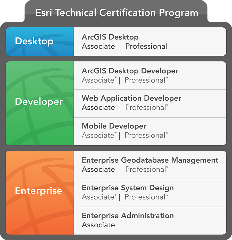
Certifications in bold are available in January 2011. * denotes certifications available later in the year.
Beginning in January 2011, users will be able to test for five certifications. The remaining eight are still in development and will be available later in the year.
Establishing an industry-recognized benchmark of expertise in using Esri software will
- Improve success with GIS by creating a community of professionals proficient in using Esri software.
- Help organizations maximize their investment in Esri products by employing a workforce certified in using best practices.
- Create professional development opportunities.
- Provide an opportunity for individuals, partners, consultants, and other organizations to distinguish themselves among their peers.
- Assist hiring organizations in assessing candidate skills and abilities.
Esri technical certification differs from another GIS professional certification, the Geographic Information Systems Professional (GISP) certification. Esri certification is based on best practices using Esri software and complements the GISP certification, which is awarded to individuals who've met standards for ethical conduct and professional practice as established by the GIS Certification Institute (GISCI).
How Were Esri Requirements Established?
Developing criteria for examinations and scoring has been a research-intensive, multiyear process involving Esri staff and outside consultancies that have helped create similar programs for other IT and software providers.
A roundtable of GIS professionals and Esri subject matter experts recommended skills to be measured for each certification. These were then vetted through extensive online surveys completed by Esri partners, international distributors, employees, and selected users.
Survey responses drove development of the examinations, which were beta tested with recruits from the same audience. Beta testing of exams verified that the appropriate questions were being asked, determined the optimal number of questions for each exam, and established final scoring models.
This process will continue for the eight certifications still in development.
Examinations
Workplace experience, combined with GIS education and Esri training courses, is the best preparation. The Esri Technical Certification Web site lists specific skills that will be assessed in each exam, as well as training courses that aid in acquiring and improving these skills.
Esri Technical Certification exams are offered worldwide through Pearson VUE, Esri's global testing partner. The computer-based exams consist of 90-95 multiple-choice questions and take approximately two hours to complete. Currently, they are offered in English only.
Within five days of taking an examination, candidates are notified via e-mail as to whether they achieved a passing score. Each exam has a unique scoring standard for passing, which is a result of extensive beta testing.
Candidates who do not achieve a passing score may retake the examination two weeks after the first attempt. If they are not successful in the second attempt, they must wait 90 days before taking the exam a third time.
The cost of taking an exam is $225, with payment made at the time of online registration.
For more information, visit esri.com/certification or e-mail certification@esri.com. To register, visit pearsonvue.com/esri.