 The Magazine for
Esri Software Users
|
|
|
Fire Agencies
Improve Response
with GIS
Fire agencies on all levels strive to preserve lives, property, and natural resources. Many agencies have embraced GIS as a tool that helps them balance needs, uses, and hazards to promote sustainability of the environment while identifying and limiting vulnerability.
 Effectively handling fires, whether structural fires in densely populated areas or wildfires raging over thousands of acres of forested land, involves planning strategic response on a regional scale, developing a tactical response for a specific event, formulating and carrying out a mitigation program, and analyzing incident data to improve policies and training programs-all activities enhanced by GIS. GIS-based fire tools range from Internet applications using Internet Map Server (IMS) technology to desktop applications developed using ArcView GIS and its extensions to sophisticated real-time enterprisewide applications using ArcInfo.
Developing Regional Strategies
Strategic planning answers three location-based questions: Where are the hazards? Where are the areas at highest risk? Where are the most valuable resources located? GIS is especially suited to answer these queries. Typically, strategic plans are made on a regional level with all agencies that have jurisdiction in the region involved in planning or at least agreeing to basic strategies.
Overlaying vegetation data with topography and transportation networks shows where fuel is present and identifies areas that may be hard to reach. Mapping historical data on fires, lightning strikes, arson activity, and other related events available from databases and paper records showing where fires occurred in the past can be used to gauge the likelihood of future fires. Finally, resources that are required to manage and recover from a fire such as water sources or transportation networks or resources that represent an unacceptable loss such as a hospital must be located. Aggregating data representing hazard, risk, and value factors for a region identifies areas with the highest priority.
Geography can provide a framework for organizing data from many sources that relate to fire strategy development. GIS, with its data integration and visualization capabilities that foster collaboration, is the natural vehicle for an intraorganizational and interagency development of strategic plans. GIS improves fire response by centralizing data in many formats and from many sources and integrating it with other technologies such as GPS. This means current information is quickly delivered in an easy-to-grasp format. In addition, powerful modeling capabilities, available from the desktop as well as on workstations, let planners model what-if scenarios to test the soundness of strategies. Fire agencies have exploited the power of GIS to their advantage in all types of settings.
The Cedar City Interagency Fire Center (CCIFC) in Cedar City, Utah, dispatches fire personnel for a number of agencies including the Bureau of Land Management, the National Park Service, the Bureau of Indian Affairs, and the State of Utah. When responding to a fire, CCIFC dispatchers plot real-time GPS positions and reference them against the GIS, which contains data on ownership; roads; wildlife habitats; slope classification; fire fuels; zones of moderated suppression; and other related themes that consolidate text, tabular, and other data previously available only from wall maps, manuals, and separate databases. Now dispatchers need only query an area to obtain concise instructions on the constraints and objectives for the area in question.
Making a Tactical Fire Plan
With a strategic plan in place, a more effective tactical plan can be developed. By having information on the risk to an area coupled with an idea of the location of the most valuable resources in the area, fire management can determine how and where to allocate resources when a fire does occur. Prior to an event, management can organize fire prevention activities and position suppression resources where they will be most effective. This means fire prevention budgets are spent in the most beneficial manner and resources can be used in ways that maximize protection to fire personnel as well as lives, property, and natural resources. In a typical scenario involving multiple fires, the agency managing the event has to allocate resources between competing areas. However, by developing both strategic analysis and a tactical plan, prioritizing areas and allocating resources will be optimized.
Improving Response
Responding to a specific incident requires more information than strategic planning. The analysis of hazard, risk, and value is revisited in much more detail. In the case of wildfires, data on topography such as slope and aspect as well as vegetation, weather, transportation, and other factors are used to further assess the risk for an area. Data on previous fire occurrences coupled with land use patterns and management goals give a more refined view of risk for this area. Value is determined by standard inventory types such as inhabited places or timberlands.
The Mapping Services Section for the Ventura County Fire Protection Agency, managed by Jim Kniss, has integrated GPS data with GIS to rapidly get crucial information into the hands of incident commanders.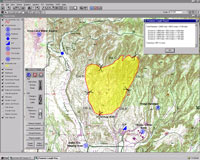 The agency has created a series of custom ArcView GIS extensions that import GPS data gathered by flying the perimeter of the fire and use standard Incident Command System symbology. These standard extensions can generate an initial attack map within 30 minutes of acquiring the incident data. The Mapping Services Section, which is responsible for all mapping products and services, also generates emergency response map books for all fire companies and cooperating agencies, wall maps for each fire station, and special tactical maps. The agency has created a series of custom ArcView GIS extensions that import GPS data gathered by flying the perimeter of the fire and use standard Incident Command System symbology. These standard extensions can generate an initial attack map within 30 minutes of acquiring the incident data. The Mapping Services Section, which is responsible for all mapping products and services, also generates emergency response map books for all fire companies and cooperating agencies, wall maps for each fire station, and special tactical maps.
Tactical response planning in an urban setting requires street network data, information on hazardous materials locations, and prefire survey information such as floor plans or hydrant location and capacity data. The Winston–Salem Fire Department in North Carolina implemented a system that uses ruggedized PCs mounted on emergency vehicles that run a custom GIS application built using MapObjects and NetEngine. The application displays a map showing the optimal route to the emergency. This route can be instantly modified to take into account streets that are blocked. The application also provides information on all available fire hydrants, any known hazardous materials in the area, the locations of special needs populations, and other pertinent information. A touch screen lets firefighters pan and zoom on the map and use icons that link the GIS application to additional information such as floor plans, diagrams, or other prefire survey information.
Developing Mitigation Procedures
Determining where and how much vegetation must be cleared around structures and developing appropriate construction material standards are just two methods for mitigating the effects of fires. The City of Laguna Beach, California, has used GIS to pursue both policies. In 1993, a fire driven by high wind conditions caused extensive damage to the City and resulted in the loss of 286 homes. The City has used GIS to help rebuild the portions of the community that were destroyed in the fire. GIS proved so useful that it has been adopted as a tool to improve City operations. As a result of the 1993 fire, Laguna Beach extensively updated the safety element in the General Plan. The availability of mapping, aerial photographs, and analysis tools in GIS helped speed and improve the revision process. The new safety element includes an emergency routing program and fuel modification specifications and requires an emergency preparedness plan that is updated on an annual basis. Zoning Analyst, a custom ArcView GIS extension developed by Esri business partner Geographic Information Services, Inc., assists planners in providing public information, processing cases, generating public notification letters, and producing maps.
Better Policies
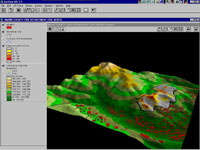
Not only is GIS used to develop and implement fire mitigation policies for local governments, but it can also help improve the policies and practices of fire agencies. 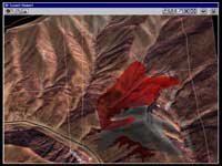 Using GIS to model the terrain, path of the fire, weather conditions, and personnel movements during a fire incident illustrates the interaction of these factors in a way that is impossible with written reports. Modeling data from the South Canyon fire that led to the deaths of 14 firefighters near Glenwood Springs, Colorado, in 1994 vividly demonstrated how the weather and terrain affected the path taken by fire. DEM data was modeled using the ArcView 3D Analyst extension, and attribute data created from scanned maps and aerial photos from the official report was incorporated into the model. Studying incidents such as the South Canyon fire using GIS can help improve fire response policies and training to minimize danger to firefighting personnel.
A Range of GIS Technologies
The pervasive use of Esri software by government at all levels means that geospatial data is often readily available from agencies in addition to an expanding array of data sets available from commercial vendors. Fire departments, government agencies, and third party developers have taken the powerful and scalable GIS technologies created by Esri for the desktop, Internet, and enterprise and developed innovative applications that improve planning, response, training, and mitigation strategies. Pacific Meridian Resources, an Esri business partner, has developed Fire!, an ArcInfo-based fire behavior model that integrates fuels and topographic data with weather, wind settings, and initial fuel moistures to let users model forest fire behavior interactively.
FIREVIEW, a new out-of-the-box solution, provides easy-to-use reporting, mapping, and analysis capabilities for fire and emergency response agencies. Developed by The Omega Group, an Esri business partner, the functionality built into the interface helps manage and analyze incidents, generate reports, track arsonists, model response time and coverage, and perform time-series animation. FIREVIEW will be released during the first quarter of 2000.
| |
