 The Magazine for
Esri Software Users
|
|
|
Celebrating GIS
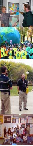 The inaugural GIS Day, November 19, 1999, provided the grand finale to Geography Awareness Week. Schools, universities, businesses, government agencies on all levels, and nonprofit organizations--a total of 2,137 registered GIS Day sites located in 91 countries--helped people in their communities learn more about GIS.
One of the original goals of the event was to educate one million children. This goal was met and surpassed as more than 1,240,000 children attended programs held in conjunction with GIS Day. More than 1,200,000 adults also attended GIS education events. In all, a total of 2,440,000 people attended demonstrations, talks, open houses, map galleries, and other programs on GIS. The event was also brought to the attention of the general public through GIS Day proclamations made in 34 states and 21 cities. Regional news agencies from Vermont to Peru covered the event as well.
GIS Day was truly a grassroots event. Sites that registered for GIS Day received logos, banners, templates, and other support materials from Esri, but program development was completely up to each group. Organizations hosting events came up with a wide variety of innovative ways to show off GIS. Here are just a few examples of the GIS Day events that were held.
- The Montana Natural Resources information System in Helena, Montana, featured activity booths that let students get hands-on experience with GIS by participating in activities such as a creating map or joining in a GIS-based scavenger hunt.
- Durham and Associates, Inc., in Shreveport, Louisiana, hosted an open house with exhibits and presentations on GIS Day followed the next day by an educational fair and field day that included a 5K run/walk, map gallery, demonstrations, music, activities, and food.
- Rain Network--Camp Internet, California, hosted live GIS focus chat sessions for classrooms from November 15-26, 1999. On the morning of GIS Day, fifty-five classrooms took part in a live Internet-based chat session with staff from the Channel Islands National Parks. They discussed current applications of GIS for mapping and environmental planning.
The National Geographic Society, the American Association of Geographers (AAG), and Esri were the principal sponsors of the event. Twelve associate sponsors provided additional support. These associate sponsors included the American Congress of Surveying and Mapping (ACSM), the Center for International Earth Science Information Network (CIESIN), the American Geographic Society, the Geospatial Information Technology Association (GITA), the National States Geographic Information Council (NSGIC), the National Council of Geographic Education (NCGE), the National Center for Geographic Information (NCGIA), the University Consortium for Geographic Information Science (UCGIS), Urban and Regional Information Systems Association (URISA), The Nature Conservancy, the World Wildlife Federation (WWF), and the Wildlife Conservation Society.
Planning for GIS Day 2000 has already begun. More than 100 organizations have expressed an interest in participating in next year's event which will be held on Nov. 15, 2000. To learn more about the GIS Day Events that were held in the United States and throughout the world, visit Esri's GIS Day site.
|
|
