|
Fire Hydrant Inventory Made Simple
with ArcPad
By Jim A. Ollerton, GIS Manager, Elsinore Valley Municipal Water District
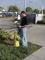
The Elsinore Valley Municipal Water District (EVMWD) in Southern California will update data on approximately 4,000 fire hydrants using ArcPad, a handheld computer, and a GPS unit. By using custom forms created for ArcPad, data collectors will not only verify the location of the district's hydrants but will also gather information on the make, condition, and capacity of each hydrant.
| |
EVMWD is updating data on approximately 4,000 fire hydrants using ArcPad.
|
|
|
EVMWD has provided water service for the past 48 years. Located in the southwestern portion of Riverside County, the district covers a 96-square-mile area from the Temescal Valley to Murrieta and serves the cities of Lake Elsinore, Canyon Lake, and Murrieta and the unincorporated communities of Wildomar, The Farm, Cleveland Ridge, and Lakeland Village. EVMWD has approximately 28,000 water, wastewater, and agricultural services.
EVMWD's 125 employees maintain a water distribution system that consists of 420 miles of transmission and distribution pipelines. This system includes roughly 4,000 fire hydrants. EVMWD uses an ArcInfo-based enterprise GIS to manage this system. In 1999, the district's GIS staff began inputting fire hydrant flow tests into the GIS database and linking the results to features. During this process, staff discovered that many hydrants were not in the GIS database. These hydrants exist in an older part of the distribution system that has poorly kept records.
In addition to the need to simply locate all the hydrants to link the test results, the local fire authorities wanted detailed information about fire hydrants such as the type of hydrant, number of outlets, size of each outlet, and other information. Requests for hydrant information originating from two sources-within EVMWD and from local fire agencies-made the GIS staff decide that it was time for a fire hydrant inventory.
| |
A custom form was created for collecting hydrant data.
|
|
|
The solution proposed by the staff used a Sokkia GIR 1000 GPS unit, a Compaq IPAQ PocketPC, and ArcPad from Esri. The existing fire hydrant database, street rights-of-way, street centerlines, and miscellaneous layers are be loaded on the IPAQ and set up in ArcPad. A custom form was created for the hydrants for data collection and update. For each hydrant, the data collector refers to the hydrant database, verifies the hydrant in the field, and inputs data into the form. A hydrant that does not show up in the database is located using GPS. At the end of the day, data is downloaded from the IPAQ and the GPS receiver. Points taken with the GPS are loaded in the ArcInfo database, and attribute information is loaded into a Microsoft SQL Server database.
A pilot area study is being used to refine this method. Based on the pilot area, EVMWD will calculate the time needed to complete the fire hydrant inventory for the entire district. Staff time will be allocated, and the data collection effort will go into full swing. The data that is collected will be linked to fire flow test data and will be accessible from the various GIS interfaces within the district. Having this information readily available will save the district time and money and ultimately benefit the ratepayers.
For more information, please contact
James A. Ollerton, GIS Manager
Elsinore Valley Municipal Water District
31315 Chaney Street
Lake Elsinore, California 92531
E-mail: ollerton@evmwd.dst.ca.us
Tel.: 909-674-3146
|