|
Are You Ready for G-Government?
G-Government is using the Internet and GIS to create more effective government. The combination of readily available Internet access and maps is defining a new level of service for governments to both business and the public. It is making collaboration between government agencies possible in new and powerful ways. With maps, data has context and meaning and can be managed and queried far more easily than if that data was presented in tabular format. The strong data integration abilities of GIS let governments truly capitalize on data existing in legacy systems.
| |
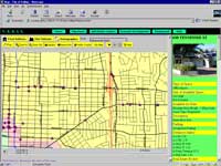
Vallejo's economic development site helps businesses locate available commercial sites and research economic characteristics.
|
|
|
Initially, government Web sites delivered little more than phone numbers and mission statements. Giving the public phone numbers that were only answered between 8 a.m. and 5 p.m. really didn't improve service. GIS has helped government Web sites become a tool for collaboration, communication, and service. GIS-enabled Web sites can provide services like online booking, fee payment, and application submission that were not previously available.
G-Government is symptomatic of the ever-widening impact of GIS. Originally GIS use was limited to GIS professionals. The development of applications, such as ArcView GIS, coupled with more powerful desktop computers, has made GIS available to professionals in many fields who use GIS to work more efficiently and effectively. With the development of Internet map serving technologies, notably ArcIMS and RouteMAP IMS, GIS use has become so easy and ubiquitous that people are often unaware they are using GIS. Internet use of GIS is driving the development of exciting new applications and nowhere is that more apparent than in government. This is no longer an emerging trend-it has become a dominant force.
In addition to ArcIMS, G-Government technologies include ArcGIS, ArcSDE, and ArcPad. Working together, they create, manage, and transfer spatially enabled data. The tremendous improvement in data resources, exemplified by the Geography Network, has also been critical to the success of GIS on the Internet. The Geography Network provides immediate access to the latest maps, data, and related services. This foundation of robust GIS and data infrastructure has led to the development of three major types of G-Government applications-government to business, government to citizens, and government to government.
- Government to business applications typically relate to economic development, land development, licensing, or permitting.
- Government to citizens applications provide information on government services such as trash pickup, or streamline the public's interaction with government agencies by allowing online payment of fees or providing feedback to officials.
- Government to government applications improve the amount, quality, and speed of information exchange between various levels of government and/or agencies and departments within governments. Better communication helps governments use resources more wisely by avoiding duplication of effort and allows agencies to work together to tackle large-scale problems or respond to emergencies.
Government to Business
Internet applications make government information available to businesses on a 24/7 basis. Business interaction with government at all levels-local, regional, state, and federal-can be improved through the use of such applications.
Cities have benefited tremendously from G-Government applications that address economic development. The Vallejo Economic Development Information System (VEDIS), an award-winning application developed by GIS Planning, Inc., is an outstanding example of this type of application. Prospective businesses visiting the site can search the City's database to locate available commercial sites; access business listing information; analyze demographic, economic, and traffic count data for the surrounding area; and generate custom reports. Local real estate agents work with the City to keep the listings in the database current.
The benefits of using the Internet to promote economic growth aren't limited to city governments. An article in this issue, "Regional GIS Promotes Economic Development," describes how Umpqua Regional Council of Governments (UR-COG) in Oregon used grant money to promote the development of industry, residential housing, and tourism in the area through a GIS-enabled Web site.
The State of Delaware is using GIS on the Internet to get information on employment opportunities to people looking for work. The Career Directions Web site is not just a listing of job openings. Visitors enter an address, and the site will map nearby available transportation, child care, and educational and training institutions as well as job information. The site generates directions to any of these locations. The site also has links to related resources such as monetary benefits, workplace protections, and labor market information. It has proven so useful that Delaware Department of Labor staff members use it to locate information for clients.
Government to Citizens
The
City of Sacramento has been an innovator in using the Internet to get government services to citizens. Its initial implementation was described in an article entitled "Sacramento Serves Public Timely Information over the Web" that ran in the April-June 1999 issue of ArcUser magazine. Both the functionality of the site and the number of visitors that frequent it have grown enormously in the intervening years.
This site definitively answers the question, "Is Internet a viable tool for delivering services?" Logins to the site have increased from 300 to 500 per day. This translates into better service for the public and real savings for the City. Without the site, 500 people would have to actually visit or call City Hall to obtain the information they now receive remotely. Not only do citizens receive better service but they also receive it at a fraction of the cost of delivering service in the traditional manner by paying counter staff. By calculating the amount of time required to answer these queries and relating it to the average hourly rate for counter staff, the City of Sacramento estimates it saves $1.8 million per year by using the Internet.
Improved service can also mean the ability of citizens to pay fees without visiting City Hall. Des Lauriers & Associates Inc., is one of several Esri business partners that have pioneered online applications that speed services to the public. Des Lauriers & Associates offers cities, especially small cities, the ability to collect fees online using Geographic Town Management Systems (GeoTMS). GeoTMS features a user-friendly design that mimics the existing information processing routines of municipal personnel but enhances these processes with built-in shortcuts, integrity checking, data sharing, security, and GIS capability. Cities are not charged for the services. A small transaction fee is charged to the user. The 12 applications developed by Des Lauriers & Associates use ArcIMS and ArcSDE. Currently, approximately 140 jurisdictions use this service.
Residents of the City of Los Angeles, California, can get more enjoyment out of their tax dollars with the help of GIS. A RouteMAP IMS application developed by the City's Recreation and Parks Department locates the nearest parks, golf courses, tennis courts, public swimming pools, and other department facilities and generates driving directions. Another RouteMAP IMS application promotes City cultural events. Members of ArtsCard LA receive discounts at participating businesses such as museums and galleries. A Web-based system helps members locate ArtsCard LA businesses and provides driving directions.
Government to Government Applications
Local, state, and federal government agencies collaborate on a daily basis. These agencies share data, coordinate emergency efforts, and work on problems such as environmental remediation that cross jurisdictional boundaries. Internet applications can streamline these interactions.
Disseminating information rapidly and widely is one of the most common areas of government-to-government interaction. The United States Census Bureau's American FactFinder site illustrates the power of letting geography organize information. The site lets state and local governments quickly access the census data needed for planning, economic development, and other activities.
GIS-enabled Internet applications help governments work together on big problems. Interagency cooperation fostered by a new Web application helped coordinate a response to the devastating wildfires that burned more than 5. 9 million acres in the western United States in 2000. Federal firefighting agencies and private industry created the Geospatial Multi-Agency Coordination (GeoMAC) group. GeoMAC developed an Internet application based on ArcIMS and ArcSDE that provides decision support for prioritizing the use of wildfire suppression resources and critical information for public and firefighter safety. Information on the location and spread of all active fires, the proximity of fires to populated places, and basemap and terrain information are immediately available so that macroscale resource decisions can be made intelligently. An article written by one of the developers of this application detailing the creation of the GeoMAC application can be found in this issue.
Tillamook County, Oregon, an area plagued by devastating floods, partnered with the federal government as part of an effort to develop a more sustainable community. The County participated in the Community Federal Information Project and developed a Web-based spatial information tool for evaluating project progress and communicating with federal agencies. The project received a Hammer Award from the National Partnership for Reinventing Government.
Departments within the same city, county, region, or state also benefit from improved data access and management. An article in this issue describes how the cities of Sarasota, Florida, and Houston, Texas, replaced older, department-specific applications with Web-based enterprise GIS systems that share data between departments.
Having It All
| |
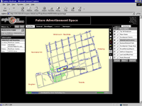
"Exploring Markham" uses ArcIMS to communicate with businesses, citizens, and other government agencies.
|
|
|
Just as GIS use by governments was initially on a project basis but developed into departmental applications and then to enterprisewide solutions, GIS applications for the Internet are becoming more robust and encompassing. "Exploring Markham," an enterprise GIS application built by Orion Technology Inc., includes government to business, government to public, and government to government functionality. The application developed for Markham, a suburb of Toronto in Ontario and self-proclaimed high-tech capital of Canada, is a thin-client Web-based application based on component architecture that can be easily expanded to meet future demands. It was awarded first place in the ArcIMS application contest at the 2000 Esri International User Conference.
This application, as well as the other previously cited, demonstrate that the Internet is a viable method for creating and delivering better government. Governments can now offer services previously not available and provide more traditional services at reduced cost. Interactive, GIS-enabled sites open up the doors of government by encouraging collaboration between government, business, and the public. For more information on G-Government solutions, contact
Christopher Thomas
State and Local Government Solutions Manager
Tel: 909-793-2853, ext. 1819
E-mail: cthomas@esri.com
Or
visit the Esri Business Partners Web site to learn more about
G-Government solutions developed by Esri business partners.
|