ArcUser Online
 |
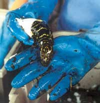
Employees at DANECO, Inc., an alligator farm in southern Louisiana, can now call themselves GIS users. DANECO, a privately owned alligator farm located approximately 50 miles southwest of New Orleans, Louisiana, has provided alligator meat and skins to Louisiana and world markets for more than 15 years. In 1967, the American alligator was listed as an endangered species under a law that preceded the Endangered Species Act of 1973. Further protection supplied by the Endangered Species Act helped the population recover to the extent that wild alligators can now be taken during the month-long hunting season in Louisiana. Hunting quotas are controlled by allocating tags to each licensed hunter. However, public demand for alligator goods exceeds what is gathered during this short and very controlled hunting season. Farms like DANECO meet this demand with farm-raised alligators. Each July, alligator eggs are gathered from wild nests across the Terrebonne Estuary in south-central Louisiana and brought to the DANECO farmstead. The eggs hatch in August. Within 18 months, the young alligators have grown to harvest size. By law, farmers must release 14 percent of these juvenile alligators back into the wild. Biologists believe that the number of alligators currently released exceeds the number of young alligators that would survive if they had been hatched in the wild. DANECO wholesales alligator meat to finish processors who distribute it primarily to restaurants. Approximately 95 percent of the skins are shipped overseas to produce bands for wristwatches. The remaining skins are sold domestically for boots, wallets, and belts. No part of the animal is wasted. Locating alligator eggs laid in the wild presents a challenge for DANECO. Alligators build nests in late summer with little regard to land ownership. However, DANECO, like other alligator farming operations, must maintain leases with landowners so that it can gather eggs from these nests. To manage egg collection more effectively, DANECO wanted maps that provided better mapping accuracy. The generic map data set included with the GPS units DANECO used did not capture the intricacies of Louisiana's coastal wetlands where alligators build nests. DANECO wanted to create its own maps using GPS waypoint data and aerial photography. The company contacted Geographic Computer Technologies, LLC (GCT), an Esri business partner in nearby New Orleans, to learn how to apply GIS to egg collection. Before using GIS, DANECO flew over promising nesting areas with helicopters and used GPS to record the coordinates of any nests spotted. These waypoints were used to approximate nest locations on paper maps and were entered into GPS units aboard airboats to navigate to the nests. DANECO wanted to use ArcView 8.1 to map nest sites so that land ownership of the sites could be determined. Digital orthophoto quarter quadrangles (DOQQs) of the State of Louisiana, used as a photo background, and parcel data from Burlington Resources Inc. were combined with the GPS waypoints to develop these nest maps. GCT provided DANECO with technical support for working with multiple map projections as well as CAD to GIS data conversion assistance. After DANECO employees worked through the tutorials that come with ArcView 8.1, they required just a few hours of training to understand the basic editing tools and become productive users. DANECO's experience demonstrates that new GIS users can easily learn ArcGIS software and accomplish things that used to require a much higher level of GIS experience. How will ArcView 8.1 be used by DANECO? Although it was purchased after the eggs were collected in July 2001, the location data collected as waypoints from helicopter surveys will be analyzed in ArcView 8.1 to determine the shortest routes between nests to optimize collection for the 2002 season and succeeding years. Information on the number of eggs that were harvested from each nest may be added as attributes to the next location data for future analyses. For more information, contact
About the Author Gregory Hymel is a senior GIS analyst with Geographic Computer Technologies, LLC. He received bachelor's and master's degrees in geography from the University of New Orleans. After completing his undergraduate studies, he worked for Tulane University's Natural History Museum. He georeferenced more than 15,000 fish collections while working for the museum. His graduate work involved computer simulations in ArcInfo to determine hydroacoustic remote sensing sampling schemes for submersed aquatic vegetation (i.e., seagrass). He has worked for private firms as a consultant for local governments and has developed GIS databases for tax assessors, GIS implementation plans, enterprise database designs, and training procedures. His current GIS interests include using GIS to preserve Louisiana's coastal wetlands and developing Internet GIS applications. |
||||||||||||||||