ArcUser Online
 |
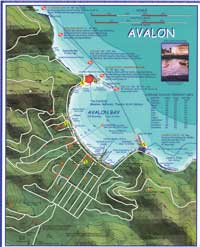
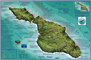
Nielsen's extroverted personality, unusual for an engineer, is a tremendous asset in gathering and verifying information for his maps. Once a prototype map for an area is done, he travels to that area for some ground truthing. The process is part research, part subtle marketing. By contacting dive boat operators, bike store owners, travel companies, and other recreation businesses, he not only verifies the information gleaned from books and other sources but finds out information that only locals, intimate with the beaches, coves, or trails in an area, would know. He eliminates outdated or just plain wrong information. Involving many of the people who are likely to be the eventual distributors or purchasers of a map in its creation has an added bonus. It convinces them of his commitment to providing a quality product while letting them know about the map at the same time. This map "test driving" also improves the usability of Franko Maps. When Nielsen gave a map of Crystal Cove Underwater Park that he is currently working on to a ranger at the park, he discovered that the vertical format he chose just didn't work for her or any of the other people at the beach. Upon returning home, he reformatted it in a matter of an hour or two. Using ArcView GIS, he eliminates time-consuming and exhausting drawing and redrawing and can concentrate on experimenting with maps and making them better. "Now I can manipulate it every which way. I can change the change intervals and the color and everything else," he said. Friends ask Nielsen if he isn't afraid someone will copy his maps. His love of both oceans and mountains is the fundamental inspiration for his maps. His quest for the most accurate and detailed information presented in the most aesthetically pleasing manner sets his maps apart. "I'm different, therefore my products are different. I get e-mails and letters on a continuous basis from people who like them," he said. Nielsen had continued at his federal job, but it was becoming increasingly clear that it was not what he really wanted to do. By November 3, 2000, the list of distributors of Franko Maps had grown long enough that he felt comfortable quitting his engineering job. He hasn't regretted the decision. "I would much rather be doing this. I have 14 map products and many more in the process or planning." Though he remains the sole mapmaker, his wife does the bookkeeping for the business. Now trips to Hawaii and Cayman Islands are "all business." "It's a terrible side benefit," he jokes. "I have to go to all these really rough places. People ask me, 'Do you need an assistant?'" Fans of Franko Maps include Jean-Michel Cousteau, the eldest son of the late Jacques Cousteau. Cousteau approached Nielsen at a dive trade show seeking an autograph. They traded autographs. Cousteau subsequently introduced Nielson to dive shop owners and others interested in maps of recreational areas in Florida and the Caribbean. Maps for Big Bear, Orange County trails, and the South Coast wilderness are currently available with maps of O'ahu surfing, Grand Cayman, Little Cayman, Cayman Brac, the British Virgin Islands, and Cozumel coming soon. These maps, in folded or laminated versions, are available online individually or in sets. They can also be purchased at more than 400 dive and mountain bike stores in the western United States. By the end of 2001, Nielson anticipates his company will produce 100,000 maps.
As he adds new maps to the list, he continues updating and enhancing existing maps. The fourth edition of the Santa Catalina Island map is nearing release. His digital approach, using ArcView GIS with computer graphics programs, makes these constant refinements possible. "I will modify and improve because I'm all about improvement." For Nielsen, the journey from a mountain biker who needed a map to full-time mapmaker has been extraordinary. "I've done more than I knew I could do. Interesting is an understatement--it was miraculous." For more information on Franko Maps, visit www.frankosmaps.com. |