ArcUser Online
 |
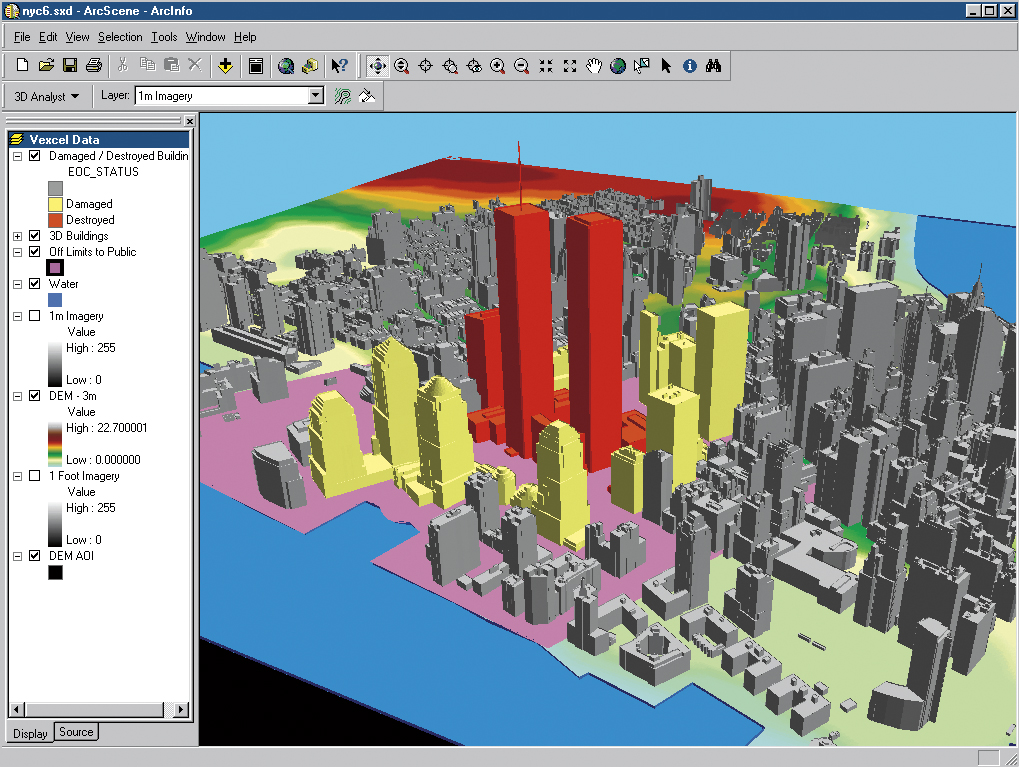
This data should not only be readily accessible but in a compatible format. A central data repository, whether physical or virtual and the development of data standards makes this possible. The g.net architecture, the foundation of the Geography Network, supports remote access to datasets in a secure, shareable, and distributed fashion. Managing access to geodata promises to be one of the most challenging social aspects of homeland security. Jurisdictional differences in policies and procedures regarding the use of geodata, intellectual property rights issues, competitive considerations, and privacy and security concerns create obstacles to making data sharable. Overcoming these obstacles may require a combination of legislative and administrative actions. It is important to understand difference between shared data and sharable data. With GIS, each organization can completely control access to its data but maintain data in a form that can be shared in an emergency. In the event of an emergency, the first priority should be controlling the event, not rounding up data for analysis. The experiences of those responding to September 11 events in New York City illustrate the validity of this point. Although the City had good GIS data, it was in different locations with no central administration. An integrated GIS had to be quickly built before good response and analysis could be produced. Developing RelationshipsGIS encourages consensus by helping individual stakeholders understand how their data relates to data from other stakeholders. Consensus is essential for marshaling support so that the recommendations derived from analyses can be put into action. Benefits can only be realized if funds are spent, policies changed, and processes modified. GIS can be the catalyst for these changes. The GIS capability to model a potential attack lets policy makers truly understand the consequences of the attack and legitimizes the need for mitigation and preparedness expenditures. Data coordination and emergency response planning efforts have an added benefit. These activities build relationships between people in agencies, departments, and organizations. An old bromide of emergency management is that "people at the scene shouldn't be exchanging business cards." The process of gathering data develops relationships between people who would not necessarily have any reason to interact except in an emergency. GIS is the primary tool that allows people with different missions come to together and develop a common plan to address an event. GIS allows people to have a common vision. With this common vision, they can work effectively for homeland security. Esri's goal is to help communities deal with threats to homeland security using technology that gets the right information to the right people at the right time. Visit Homeland Security for more information on the use of GIS for community safety, or contact Russ Johnson, Esri public safety solutions manager, at russ_johnson@esri.com or Lew Nelson, Esri law enforcement solutions manager, at lnelson@esri.com. |