MDEP Deploys Distributed GIS Application
by Stuart Rich
St. George Consulting Group, Inc.
Since the 1970s, the State of Maine's Department
of Environmental Protection (MDEP) has overseen the control and
disposal of hazardous and waste products through its Bureau of Remediation
and Waste Management (BRWM). In recent years, the bureau has sought
to develop a better method for providing its staff with efficient
and accurate access to the data needed to respond to spill events.
The Division of Response Services, one of six divisions
under BRWM, provides round-the-clock management of oil, hazardous
waste, and hazardous material spills through its Statewide staff
of 25 "responders." Responders are the MDEP's first line
of defense at the approximately 2,700 spill events that occur annually.
Through their efforts, hazardous material releases
are contained and further contamination of the environment reduced.
A wide array of equipment and significant financial authority help
responders mobilize appropriate cleanup actions. Making the best
use of these resources in the precious time immediately following
a spill requires that responders make very quick assessments of
the relative gravity of each situation. These assessments are based
on answers to some of the following questions.
- What is the nature of the material that has been spilled?
- Are sensitive environmental areas nearby that should be protected?
- Are there any public health risks nearby?
- Have there been other spills in the area?
- Does the individual involved with this spill have a history
with MDEP?
In large measure, the effectiveness of the actions
ordered is determined by responders' ability to evaluate these and
many other questions. Responders also collect information about
each spill event. This information, presented in a spill report,
is entered into the MDEP system within 90 days of the spill event.
Spill report information is used by other MDEP personnel to evaluate
any changes in environmental risk, track the department's overall
workload, and monitor cleanup costs and reimbursements.
The response reporting process was originally paper-driven.
In the 1980s, it evolved into electronic formats. Despite various
iterations, the process has been hampered by serious limitations
stemming primarily from the completely office-bound nature of MDEP
datasets.
Responders in the field gathered information without
being able to relate the current spill event to past events or extenuating
circumstances. Given the speed with which on-the-spot judgments
must be made in such situations, this lack of access to data about
past spills, geology, public health risks, or sensitive environmental
areas in proximity to the current event could compromise responders'
prescribed cleanup actions. Responders were unable to access GIS
data while in the field and had to return to one of four offices--in
Augusta, Bangor, Presque Isle, or Portland--to coordinate findings
with GIS data. No integrated access to other MDEP databases was
available because GIS was delivered in stand-alone applications
that were not integrated with the other applications responders
used.
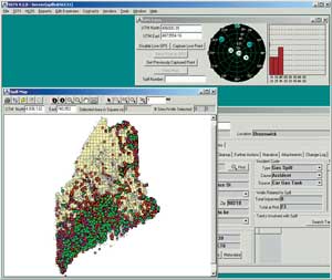 |
| HOSS users have access to integrated GIS information
and live GPS point capture from within the application. |
Working closely with BRWM, St. George Consulting
Group, Inc. (SGCI), has developed the Hazardous Oil Spill System
(HOSS). An enterprisewide database and GIS system, HOSS gives responders--whether
in the field or at the office--access to a wide range of data. HOSS
references existing MDEP datasets and provides more complete and
accurate reports that are available to concerned parties throughout
the system.
In the field, responders are equipped with ruggedized
laptops that have been installed on special truck-mounted docking
stations designed to stand up to the frequently adverse conditions
of working outdoors in Maine. These laptops are configured to accept
live GPS input from several different models of handheld GPS units.
The software can retrieve stored GPS points from handheld units
so that location data can be collected for spills that are inaccessible
to vehicles.
At a spill site, responders using HOSS can access
critical GIS data that directly impacts the effectiveness of the
spill report. In addition to more accurately ascertaining the location
of the spill, responders can quickly view the spill's physical proximity
to nearby formations that might be particularly sensitive from a
public health or environmental perspective.
For example, responders can determine how close
a spill is to public drinking water supplies or sand and gravel
aquifers. HOSS also allows responders to capture GPS points and
images and display them at the site so that the spill can be mapped
as accurately as possible. Back at the office, this information
is directly synchronized with MDEP's enterprise business databases
and enterprise geodatabase.
Continued on page 2
|