Jump-start Your ArcIMS Site
New templates for ArcIMS 3.1, available at no cost
from the ArcOnline Web site,
give any ArcIMS developer a quick method for adding a lot of functionality
and a stylish appearance to a site with little effort. More experienced
developers can also use the rich development libraries that come
with the Site Starter applications.
The Site Starter applications are a set of Active
Server Pages (ASP) applications that work with the ArcIMS ActiveX
Connector. Each Site Starter application is dedicated to a specific
business task and provides users with an intuitive method for accomplishing
that task. These applications are supplied as templates that can
be tailored to specific datasets and offer a variety of presentation
styles. Use Site Starter Applications with minimal customization
to jump-start a new Web site or use them to enhance an existing
Web site.
The Site Starter applications were developed as
lightweight (less than 50 KB), graphically adaptable, out-of-the-box
solutions for common Web site mapping needs. Using a server-scripted
model, Site Starter applications use ASP to manage queries and maps,
generate the client, and manage the business logic for the site.
The client is lightweight because it handles only the presentation
function and user input, not the application logic.
Using the Site Starter Applications
Installing these applications is as simple as one,
two, three.
- Create an Image MapService in ArcIMS.
- Copy the Site Starter application files onto your system and
run the self-extracting executables.
- Use a text editor to modify the variables that tell the application
how to access your data. The process is described in the documentation
that comes with the applications.
The Site Starter applications require ArcIMS 3.1
with the ActiveX Connector installed and Microsoft IIS 4.0. Although
Microsoft IIS is required to run ASP, ArcIMS does not have to use
Microsoft IIS as the default Web server for servlet requests. Other
connectors (e.g., the ArcIMS Servlet, ColdFusion, or AppServerLink
Connectors) and other Web servers (e.g., IBM, iPlanet, Oracle, and
other vendors) can be used while the Site Starter applications use
Microsoft IIS to communicate with the ArcIMS Application Server
through the ActiveX Connector. The documentation that comes with
the Site Starter applications supplies detailed information on the
requirements, installation, and configuration for each application.
The Viewer Application
The Viewer application is a lightweight alternative
to the clients that come with ArcIMS-the HTML Viewer and the Custom
and Standard Java Viewers. The Viewer application provides basic
map navigation and query tools and enhances output with legend generation
and print layout capabilities. This viewer has three basic styles
that can be modified by changing the Cascading Style Sheets that
control its display properties.
Default configuration for the Viewer application
supports a single-click HTML form for map interactions such as zoom
and identify using the Map.asp page. However, dynamic interaction—rubberband
zooming or dynamic recentering—is supported by the Map_DynamicHTML.asp
page, which provides this functionality through JavaScript and DHTML.
Implementing the dynamic viewer is as simple as substituting Map_DynamicHTML.asp
for Map.asp. Rename the original Map.asp to Map_SingleClick.asp
and rename Map_DynamicHTML.asp to Map.asp.
The Search Application
The Search application lets users search for geographic
features in the same way they search for other things on the Web.
Users are familiar with search engines such as HotBot or Yahoo,
which accept input at a search page and return summarized results.
The Search application works in the same fashion. Once a query is
submitted, it returns a results page showing the features that fit
the query, summarized in tabular format. After selecting a feature
from the results page, the user can obtain either a detailed report
on that feature or a map showing the feature.
The Search application provides better performance
because it separates database and GIS queries and performs GIS queries
for specific features. The initial database query retrieves a recordset
that is displayed on the results page. When a map is requested for
a feature on the results page, the Feature ID for a selected record
is passed by the ArcIMS ActiveX Connector to the ArcIMS Application
Server to locate the desired feature and generate the map on a Web
page.
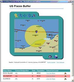 |
| The Buffer application searches a database
for a query item, locates it graphically on a map, and determines
what features are located within a specified distance from the
query item. |
The Buffer Application
The newest Site Starter Application, the Buffer
application, was created in response to user interest. This application
searches a database for a query item, locates it graphically on
a map, and determines what features are located within a specified
distance from the query item. Like the Search application, this
application employs different methods and technologies for these
three steps to optimize performance.
The Site Starter applications were developed by
Dave Wrazien and Lee Bock of Esri. Contact Dave Wrazien at dwrazien@esri.com
with suggestions on existing or future applications. Download the
Site Starter applications. A sample dataset is also available
from the same location.
|