ArcUser Online
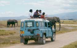
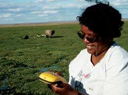
In the 1970s and 1980s, Kenya, overall, lost nearly 85 percent of its elephants to ivory hunters. This disturbing trend was repeated to varying degrees across Africa with one notable exception—Amboseli National Park in southern Kenya near Tanzania's Mount Kilimanjaro. Here pachyderm herds have grown while others have dwindled. Much of the credit for this counter-trend must go to the Amboseli Elephant Research Project (AERP), which began watching over the park's elephants in 1972. For the past 30 years, AERP researchers have observed the animals on a daily basis—counting bulls and cows, recording deaths and births, identifying families and individuals, and tracking elephant movements and activities in the 150-square-mile park. The AERP database now holds more than 30,000 observations. It is the key to understanding elephant family dynamics and determining which management practices help the animals to survive and thrive in their native environment. Although location is a primary input to every observation sighting, AERP had no means of analyzing the data spatially until 2001. AERP was introduced to the spatial age with the donation of the ArcGIS 8.2 suite from Esri. For the first time AERP researchers could visualize elephant migration through the park and relate their movements to seasonal, vegetative, or climatic changes. Mapping 30 years of observations offered a geographic overview of the different ways in which individual elephants and families responded to changes in their environment. Gaining access to the legacy AERP files for spatial analysis was easy. Since the early 1990s, AERP had been storing its field observation data in a Microsoft Access database. It was a very simple process to convert it to a personal geodatabase in ArcGIS 8.2. However, like many other GIS users, AERP researchers were eager to leverage the power of mobile GIS to improve the accuracy and speed of fieldwork. Trimble donated five GeoXT units, rugged integrated GPS handheld devices with Windows CE software. The first of these units arrived in Kenya equipped with ArcPad. AERP faced a challenge that many mobile GIS users are dealing with today—integrating data from ArcPad with legacy data. With assistance from Elizabeth Sarow, an Esri technical marketing specialist based in Denver, the Amboseli program developed a solution. Customizing ArcPadSarow traveled to Kenya in fall 2002 to customize the units for AERP's use and train the research staff. Loading ArcPad onto the GeoXT was a simple task. The device is designed to run this popular mobile GIS software. The Trimble GeoXT Getting Started Guide contains step-by-step directions for loading and setting specifications to run ArcPad. "It took only 15 minutes to have the units running ArcPad," said Sarow. The next step was to create a customized user interface for data entry. The researchers collected the field data on paper data entry sheets and later keyed it into the Access database at the field station. Sarow based the ArcPad edit forms on the Access data entry form in use. Using a drag-and-drop process, she built a series of six edit screens that walk the user through a typical observation session. Field data is inputted by using a stylus to pick choices from a drop-down menu or by using the Windows CE keyboard for text fields.
The first edit screen prompts the field worker to record the location, sighting number, observer name, and habitats where the elephants are being observed. Subsequent screens enable the observer to describe the group, enter the number of animals, and identify families and individual bulls, when possible. AERP had normalized the Access database with multiple tables to avoid duplication of data relating to a single observation. This was necessary because a single field sighting often involves recording details about several individual cow families or bulls. This data is stored in different tables in Access, yet is linked to the table containing the location data. Sarow used VBScript, the programming language for ArcPad, to create a custom script that transfers some data inputs from the ArcPad edit form into separate tables, for use in Access. This code also maintains the link between the multiple related tables and location data for each sighting. In an ArcPad edit form, controls are bound to fields in the shapefile and are updated automatically. However, because tables for the cow families and bulls are related to the observation location shapefile, these values are not automatically updated by the edit form. Consequently, related tables had to be updated programmatically and a linking ID had to be maintained between the shapefile and the related tables for each observation. For each sighting, an observation ID (i.e., a sequential number) is generated by the program. This ID value is the link between the location shapefile record and the related records for cow families and bulls. For each cow family sighted at an observation location, a record is entered into the cow family's table, which contains the linking observation ID value and the cow family name. Similarly, if a bull is seen, a record containing the linking observation ID value and the bull ID is entered into the bulls table. ArcPad provides an object model that assists the user in building a customized application in ArcPad. "An Esri user who is proficient in VBScript is able to write the code needed for customized ArcPad data collection," said Sarow. Because AERP researchers make their database available to other individuals and organizations in the research community, which has standardized on Access, data continues to be maintained in Access, rather than in a personal geodatabase. For this reason, the final step in the customization process was to write a conversion routine that brings the data from ArcPad into Access. It converts the shapefiles into the tabular data files required by the relational database. To accomplish this, Sarow used ArcObjects, which comes with ArcGIS. The code for the conversion is written in Visual Basic and utilizes ArcObjects and Microsoft ActiveX Data Objects (ADO). ArcObjects was used to read data from the shapefile and related tables that ArcPad created. ADO was used to write the data to the Access database. Again, the challenging part in the data conversion process was to maintain the unique observation ID that is the link between the spatial data and the related tables. In the AERP database, when an observation data record is added to the Access table, an autogenerated ID is created that links the ID to the related tables. This ID was substituted for the one maintained in ArcPad. When the related records for cow families and bulls are added, they use this new ID, too. Continued on page 2 |