ArcUser Online
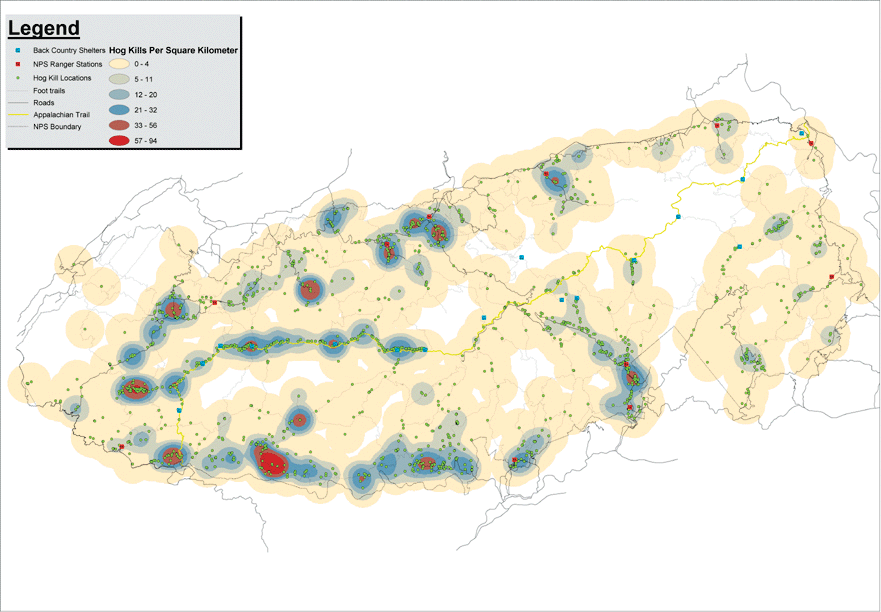
Wild boars, an exotic species in North Carolina, rapidly became entrenched in the mountainous terrain adjacent to the area where they were originally introduced. This rapidly growing population began spreading in a predominately northeasterly direction into the uplands of both North Carolina and Tennessee and into an area destined to become the GSMNP. Approximately 22 years after wild boars were introduced, the GSMNP was established on the North Carolina/Tennessee border. The park lies in the southern extension of the Appalachian Mountains approximately 30 miles to the northeast of the initial wild boar introduction. The GSMNP (in the words of Executive Order 11987 which established it) was created "to preserve, maintain, and restore natural ecosystems and natural processes in as nearly a pristine condition as possible." It seemed inevitable that the advancing wild boar population would have an impact on the newly formed park. By the late 1940s, boars began appearing in the southwestern extremes of the park area. Their effect on the park's native flora and fauna was immediately evident. Normal boar feeding behavior, called rooting, disturbs the soil. Hog rooting destroys vegetation, reduces small mammal refugia, and worsens the effects of erosion. As part of control efforts in the late 1950s, approximately 60 wild boars per year were displaced and/or removed. Current control efforts remove approximately 300 wild boars annually. Despite these efforts, wild boars in the GSMNP continue to be a major management problem. Properly ascertaining equitable distribution of parkwide hog control efforts required the display of successful hog removal graphically in a spatially referenced format. GIS IntegrationIn January of 2002, the University of Tennessee at Chattanooga procured hog control records for 1976 to 2001 from wildlife control officers Kim Delozier and Bill Stiver at the GSMNP headquarters in Gatlinburg, Tennessee. Hog control records had been archived by the Park Service using Microsoft Access 2000. A total of 8,521 animal take (i.e., hog removal) records were compiled, representing approximately 376 tons of wild boar taken over a 26-year span. Of the 8,521 records, only 612 were properly georeferenced using Universal Transverse Mercator (UTM) coordinates. The remaining 7,909 records were spatially referenced in a post hoc fashion using 2001 topographical maps from National Geographic Holdings, Inc., and the written descriptions of animal takes. Animal take records provide the location of the take, the date of take, capture type, sex of animal, age/class distribution (i.e., piglet, juvenile, adult), moon phase, approximate weight of the animal taken, and control officer. Locations of animal takes were displayed in ArcMap using 7.5-minute United States Geological Survey (USGS) topographical maps projected in UTM Zone 17 in North American Datum of 1927 (NAD27). Thirty-meter digital elevation model (DEM) data in Spatial Data Transfer Standard (SDTS) format was converted into grid format using the ArcToolbox DEM to Grid tool and merged using the raster calculator in the ArcGIS Spatial Analyst extension. The highest historical animal take areas are portrayed in dark red with decreasing densities shown in a lighter shade of red, then blue to white. ResultsMapping 26 years of hog control data showed that successful animal take locations were not distributed uniformly but appear in clumps. Extremely high kill densities appear only in a few hot spots—the most hunted areas of the park. Most hot spots are clustered around paved roads, the Appalachian Trail, and backcountry hog hunter shelters. Less accessible areas of the park are under-hunted and appear on the map as large expanses of tan or white. Early researchers had hypothesized that if hog control efforts were not uniformly distributed throughout the GSMNP, efforts to control the wild boar population might actually stimulate population growth. As this mapping endeavor showed, hog control efforts through 2001 have had highly uneven success. Future ImprovementsBeginning in January 2002, GSMNP wildlife control officers were outfitted with Garmin III Plus GPS receivers so that future animal take records could be properly cataloged. The coordinates of important and permanent locations, such as hog hunter shelters, bait stations, and hog traps, will also be recorded using GPS. Officers Delozier and Stiver combine GPS data with GIS support provided by personnel from the University of Tennessee at Chattanooga to implement a more comprehensive and effective hog control effort in the park. For more information on this project, contact Dr. Robert Keller at robert-keller@utc.edu. About the AuthorsRobert D. Keller, Ph.D., is an assistant professor of biology at The University of Tennessee at Chattanooga and is the principal investigator of the pilot project for the Southern Appalachian Information Node (SAIN) of the National Biological Information Infrastructure (NBII). R. Gary Litchford, Ph.D., is a professor of biology at The University of Tennessee at Chattanooga and coordinator for the Environmental Sciences Graduate Program. He has been involved in GIS instruction since 1980. James C. Brinson, Andrew M. Carroll, Jason M. Houck, H. Ford Mauney, and M. Taylor McDonald are graduate research assistants in the Environmental Science Program at the University of Tennessee at Chattanooga under the NBII program on GIS applications for SAIN. ReferencesCollins, John. 1991. The Wild Boar in North Carolina. North Carolina Wildlife Resources Commission. Raleigh, North Carolina. p. 10. Howe, T.D., F.J. Singer, and B.B. Ackerman. 1981. Forage relationships of European wild boar invading northern hardwood forest. Journal of Wildlife Management, 45 (3). pp. 748-753. Mayer, J.J., and I.L. Brisban. 1991. Wild Pigs of the United States: Their history, morphology, and current status. The University of Georgia Press. Athens, Georgia. Tate, J. 1983. Techniques for controlling wild hogs in Great Smoky Mountains National Park: Proceedings of a workshop, November 29-30. Research/Resources Management Report SER-72. 87 pp. |