ArcUser
Winter 2012 Edition
Sim Disaster
A better approach to disaster consequence management
By Matthew DeMeritt, Esri Writer
This article as a PDF.
Modeling the impacts of a mass exodus from a metropolitan area on critical infrastructure and resource consumption
Large-scale disasters will always happen—often without warning. Computer modeling remains one of the most effective ways to lessen the impacts of these calamities and save lives. Simulating catastrophes can produce valuable data that helps emergency planners modify evacuation plans.
FEMA Funds New Research
In recognition of the importance of computer modeling in disaster preparation, the Federal Emergency Management Agency (FEMA) created the Regional Catastrophic Preparedness Grant Program (RCPGP) to support state-of-the-art research into emergency response methods and tools. Created to support the development of integrated planning bodies, protocols, and procedures following catastrophic events, such as wildfires, floods, hurricanes, or man-made disasters, RCPGP funds research by organizations to improve disaster response plans for the National Capital Region. [The National Capital Region is the geographic area located within the boundaries of the District of Columbia; Montgomery and Prince Georges Counties in Maryland; Arlington, Fairfax, Loudoun, and Prince William Counties and the city of Alexandria in the Commonwealth of Virginia; and all cities and other units of government within the geographic areas of the district, counties, and city.]
The flood inundation map is integrated with the modeling and simulation consequence management system to identify critical infrastructure at risk
RCPGP awarded Azimuth Incorporated a contract to conduct data collection. Mid-Atlantic Technology, Research and Innovation Center (MATRIC) was chosen to develop a state-of-the-art modeling and simulation system that combines GIS with aspects of gaming. The result was Modeling & Simulation (M&S) Capability for Resource Consumption and Consequence Management, an interactive disaster simulation program that engages users by instantly showing the consequences of emergency response decisions.
The development team's approach to analytics and simulation addresses the failures of imagination, policy, capabilities, and management that were detailed in the Final Report of the National Commission on Terrorist Attacks Upon the United States (The 9/11 Commission Report). The M&S solution provides seemingly limitless possibilities to explore what-if scenarios and integrate non-GIS and GIS technologies. It engages users by showing them the consequences of their decisions through a Flex map viewer front end. ArcGIS for Server processes and analyzes all the data on the back end. The advanced geoprocessing and comparative analytics functionality of ArcGIS for Server enabled more granular simulation than would have been possible with conventional disaster modeling software.
Model Your Own Disaster

The Modeling & Simulation prototype system simulates the impact of evacuees on the transportation infrastructure.
Planning and preparing for catastrophic disasters is a top priority at FEMA. Following such an event, FEMA's two chief concerns are the availability of transportation and resources. MATRIC and Azimuth created the M&S system to simulate the impact of evacuees on transportation infrastructure, the consequences of allocating and deploying limited supplies in specific ways, and the corresponding consumption of critical resources (e.g., fuel, water, medical supplies) during an emergency.
With M&S, users have the ability to run scenarios using more than 30 expert-approved parameters including
- Total number of evacuees
- Percentage of evacuees seeking minor medical treatment
- Percentage of evacuees seeking major medical treatment
- Percentage of evacuees seeking shelter
- Average gallons of water used per hour per shelter occupant
- Evacuation or postimpact sheltering
- Average fuel economy per vehicle
- Hospital bed availability
- Ingress points used
The breadth of user-defined parameters enables emergency planners to model a virtually unlimited number of scenarios. The modular system architecture also allows the development team to include additional parameters to meet new customer requirements.
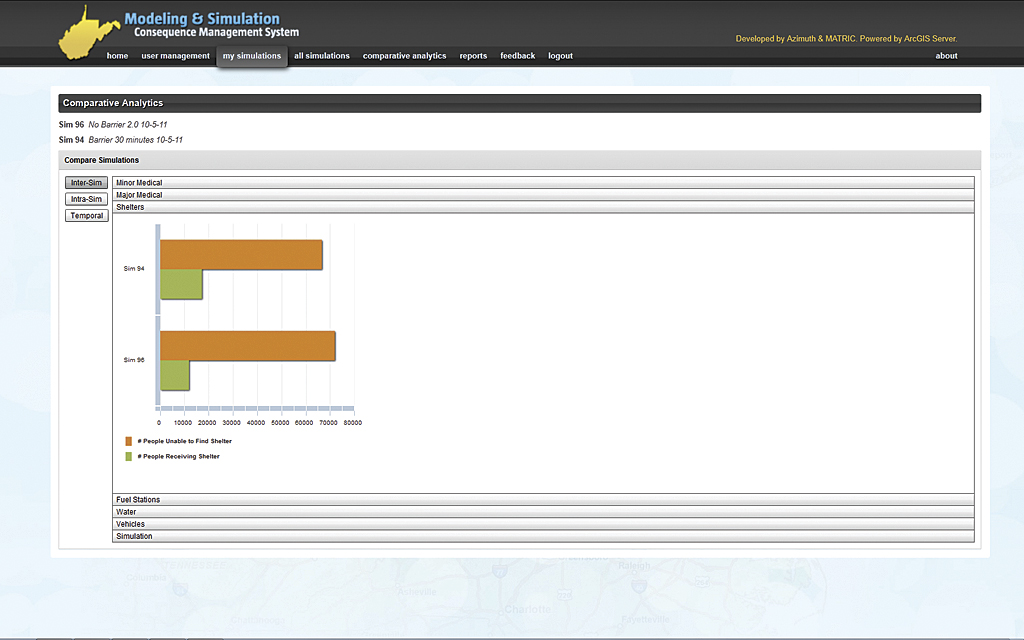
The analytic tool compares key metrics from multiple simulations, enabling emergency managers to improve response plan preparation.
Additionally, users can compare key metrics between multiple simulations to identify which response plan performs the best for a specific scenario. Users can also generate after-action reports for a specific resource, such as hospital bed availability, or broader reports encompassing all resources and their depletion rates over time.
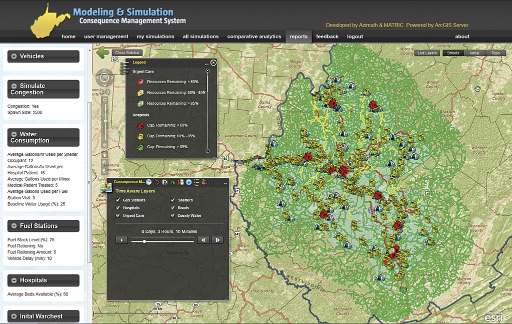
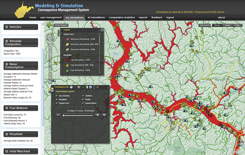
The program works by letting users interactively activate and deactivate shelters, place barriers, and enforce fuel rationing to evaluate the effectiveness of their response plan and experiment with alternative plans. The system incorporates Esri's temporal functionality. Users can pause, play, fast-forward, and rewind time to specify precisely when to execute an action during the simulation. The activation of resources, such as shelters, have a user-defined startup and per-occupant cost for required supplies for each activated shelter. The system deducts supplies for each activated resource from a "war chest" defined by the user for that simulation. The user defines the type and quantities of supplies available in the war chest and specifies the startup costs for each available user action (e.g., activate shelter, place barrier). Scenario options are limited only by the user's imagination.
SimCity Inspired
MATRIC's lead developer Vic Baker has been integrating GIS with interactive gaming concepts and virtual reality for more than a decade. The M&S system fuses GIS with gaming technologies for real-world planning and decision making. "SimCity is a useful analog to help familiarize people with this concept," said Baker. "In SimCity, you have to determine where best to deploy your available resources in any given situation."
To simulate a mass evacuation event involving millions of people, the development team needed a way to model roadways congested with millions of vehicles. Each vehicle is modeled as an intelligent agent that follows its own route, contains passengers with specific needs (e.g., seeking medical attention, seeking shelter), and has dynamic fuel consumption. The team researched existing commercial tools for congestion modeling and quickly realized that existing tools did not provide the development extensibility that the modeling and simulation system requires. To that end, the development team implemented a time-aware, congestion modeling geoprocessing service built on ArcGIS for Server. The geoprocessing service generates temporal heat maps showing increasing levels of congestion as green, yellow, and red road segments.
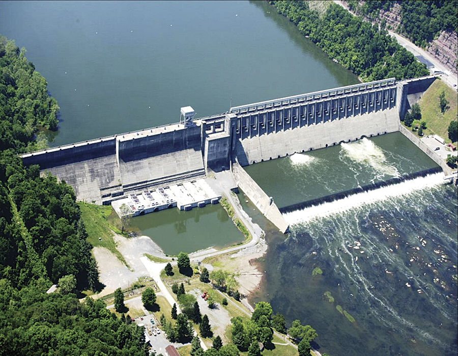
The Modeling & Simulation system was used to simulate the failure of Bluestone Dam, a concrete gravity dam located on the New River. (Photo courtesy of the US Army Corps of Engineers)
Just like SimCity, M&S users start with limited resources and must use them wisely. However, in SimCity, users who make poor decisions simply lose the game. With the M&S system, users who make poor decisions produce response plans that can endanger lives. "The point of M&S is to encourage users to experiment with scenarios and response plans so that planners can learn from the simulations," said Baker. "There's no better way to identify the flaws in a response plan than seeing it played out before your eyes."
Modeling a Real-World Scenario
To model the potential impacts of an evacuation caused by a failure of the Bluestone Dam near Hinton, West Virginia, MATRIC integrated a barrier polygon tool from its West Virginia Common Operating Picture (COP) to simulate inaccessible areas within the M&S system. "We can use the polygonal barriers in our routing logic so that anything within the impacted areas is inaccessible, and any routes that cross it are off limits," said Baker. The team has also included a flood inundation map, provided by the US Army Corps of Engineers and the West Virginia National Guard, that lets the M&S system identify shelters and medical facilities that would be unavailable in an emergency. "The inclusion of the flood inundation map allows users to identify which shelters and hospitals will be offline and thus should not be activated during the event."
The Next Phase
For the project's next phase, MATRIC is collecting data for states surrounding the National Capital Region. The team is also investigating new functionality including sheltering in place, performance optimizations, improved after-action reporting tools, and enabling the user to specify custom areas of interest and data sources for the simulation extents. The underlying intelligent agent simulation technology in M&S can also be adapted to model the spread of contagious diseases and animal migration. For more information, visit www.MassEvacSim.com.