ArcUser Online
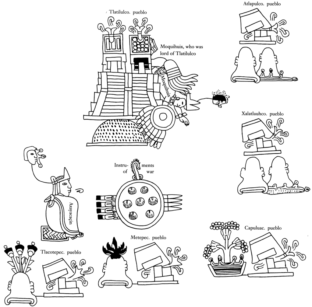
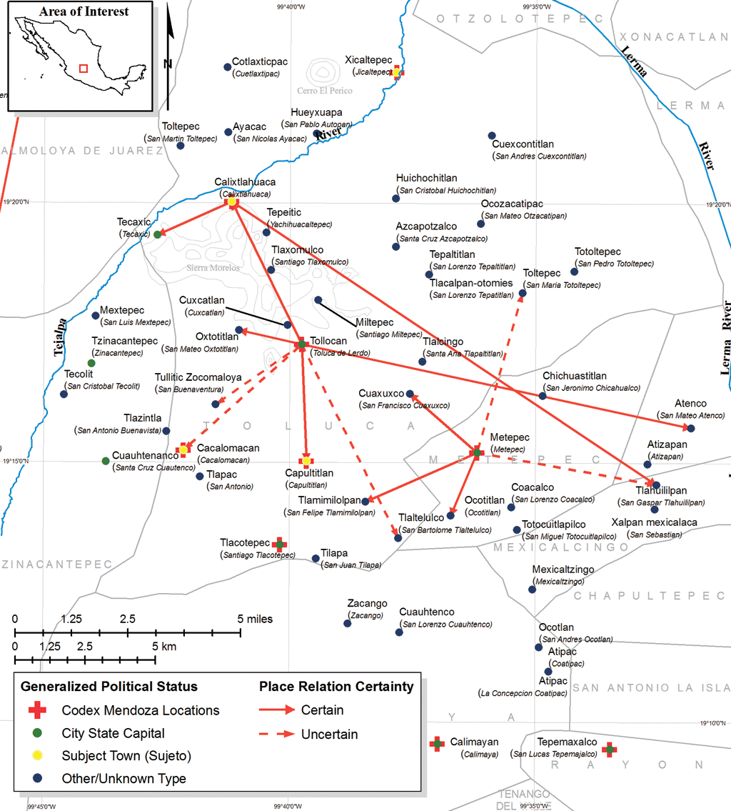
Previous research on reconstructing Aztec political geographies typically involved identifying modern place-names that have indigenous origins, matching these names to historically referenced locations, and representing these locations with generalized cartographic displays. This article describes a different approach using GIS. This approach matches uncertain locations from the past to precisely known present-day locations. The GIS approach was decisive in developing detailed cartographic summaries of social, political, and temporal phenomena of interest. Integration with geodatabase technology provided the ability to leverage tabular records derived from historical research at multiple spatial scales. With a geospatial database at the core of the investigation, it was possible to process, visualize, and examine data quickly and efficiently. The Historical RecordInvestigating geospatial historical records relating to the Aztec rule in central Mexico is challenging. The documentary evidence available covers a period approximately 20 to 50 years after the Spanish conquered the region. Investigators used Aztec and Spanish evidence, together with historical and geographic expertise, to look back to the preconquest period. Spaniards were interested in preserving the Aztecs' political and tribute structures to collect taxes and develop their own political and ecclesiastical systems within existing native systems. The Codex Mendoza [a document created to describe Spain's newly conquered lands to her king, Charles V] is one of the most important primary source documents about ancient central Mexico and Aztec political geographies. The Codex Mendoza provides place-specific information describing conquest histories, daily life, and the tributes paid to the central empire. Images in this document function as a map of historical events. These events are depicted in a non-European cartographic manner and demonstrate some of the challenges in creating GIS representations based on the historical record. Historical Database Schema Development and ImplementationA computational system was developed to capture, store, and represent historic information and help understand issues associated with pre-conquest central Mexico. A historical database was developed to support two core tasks: creating a repository for historic information that would provide query and analysis tools for nonspatial information retrieval and generating a database schema that would provide attribute base information for GIS visualization.
To visually conceptualize relationships between database objects, a logical model was developed. The database is organized by top-level data clusters or logical grouping of information. Each cluster is interrelated through key-matched information. A user-driven, time period selection query is used to extract information based on research needs. The database was implemented from the logical model. The historical database uses industry-standard database objects (e.g., tables, views) to store and relate information. Seamlessly integrating geodatabase tables with aspatial tables stored in Microsoft Access was especially helpful for data integration and analysis. Using a GIS-Based ApproachArcGIS 9 ArcInfo was used for performing analysis, processing data efficiently, and querying data structures on the fly. A place-name matching algorithm was developed to match historic place references to modern place-name points using GIS. The algorithm accepts a time period as an initial input parameter through a simple GUI. The algorithm uses a series of processing steps that determine the match confidence. These steps proceed from human-focused data matches (e.g., a modern town name for an ancient site has been established through careful historic research) to computational string comparison matches that evaluate multiple partial matches. National Geospatial-Intelligence Agency (NGA) GEOnet Names Server (GNS) supplied place-name points that were essential to the process of matching ancient place-names to modern place-names. GNS provides access to databases of geographic feature names maintained by NGA and the United States Board on Geographic Names. These databases supply 5.5 million names for approximately four million geographic features worldwide excluding the United States and Antarctica. Data can be downloaded in CSV file format with x,y values stored in a latitude/longitude (geographic) coordinate system in World Geodetic System of 1984 (WGS84). Continued on page 2 |