Interoperable Three-Dimensional GIS
Urban Modeling with ArcGIS 3D Analyst and SketchUp
This article describes what happened when 13 urban planning and architecture faculty members and students at Florida Atlantic University (FAU), who had no proficiency in CAD or GIS software, came together to create an interactive three-dimensional GIS for a portion of downtown Fort Lauderdale in only 12 days.
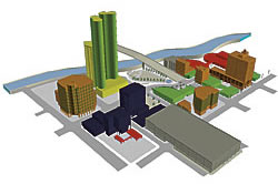
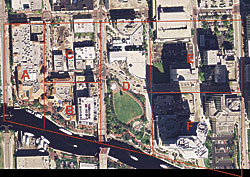 |
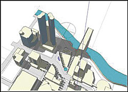
| Study area |
A working integration of three-dimensional models with georeferenced databases holds great promise for physical planning and design. It allows for simulation, visualization, shadow studies, urban wind effects, and neighborhood compatibility studies. Esri has made significant strides in the functionality of the ArcGIS 3D Analyst extension (which includes the ArcScene and ArcGlobe applications). Interoperability with dedicated three-dimensional modeling software packages, such as Google SketchUp, provide even more opportunities for real-time and interactive analyses.
On the flip side, the rapid evolution of three-dimensional GIS technology and integrative modules and plug-ins seems to be outpacing course content in academic settings. For the most part, academics remain in their disciplinary silos and promote and use software platforms with which they are most familiar and comfortable.
At Florida Atlantic University, the urban planners have traditionally taught and used GIS, while the architects have taught and used modeling/visualization software such as AutoDesSys formZ, Google SketchUp, Adobe Illustrator, and Graphisoft ArchiCAD.
GIS is associated with data overlaying and relational databases for community-level visualization and analysis in two dimensions. Architectural visualization emphasizes the representation and analysis of form, space, and material. While GIS uses layers to subdivide datasets, layering systems in architectural design typically reference material components and a language of line-weights, colors, and textures.
ArcGIS-SketchUp Interoperability
In May 2006, encouraged by an initiative for collaboration undertaken by faculty from the College of Architecture, Urban and Public Affairs at Florida Atlantic University, two planning faculty and two architecture faculty members jointly designed a 12-day intensive summer course called In[form]ed City. In this course, students would learn to map, model, assess, evaluate, and present a detailed visual and informational model of downtown Fort Lauderdale. Their mission was to collect and organize a comprehensive database at the site and study area levels; learn to use both two-dimensional and three-dimensional platforms while integrating GIS and SketchUp data, models, and databases; and incorporate the knowledge of both architecture and urban planning. Integrating GIS and SketchUp helped merge the two technologies and share ideas.
Study Area
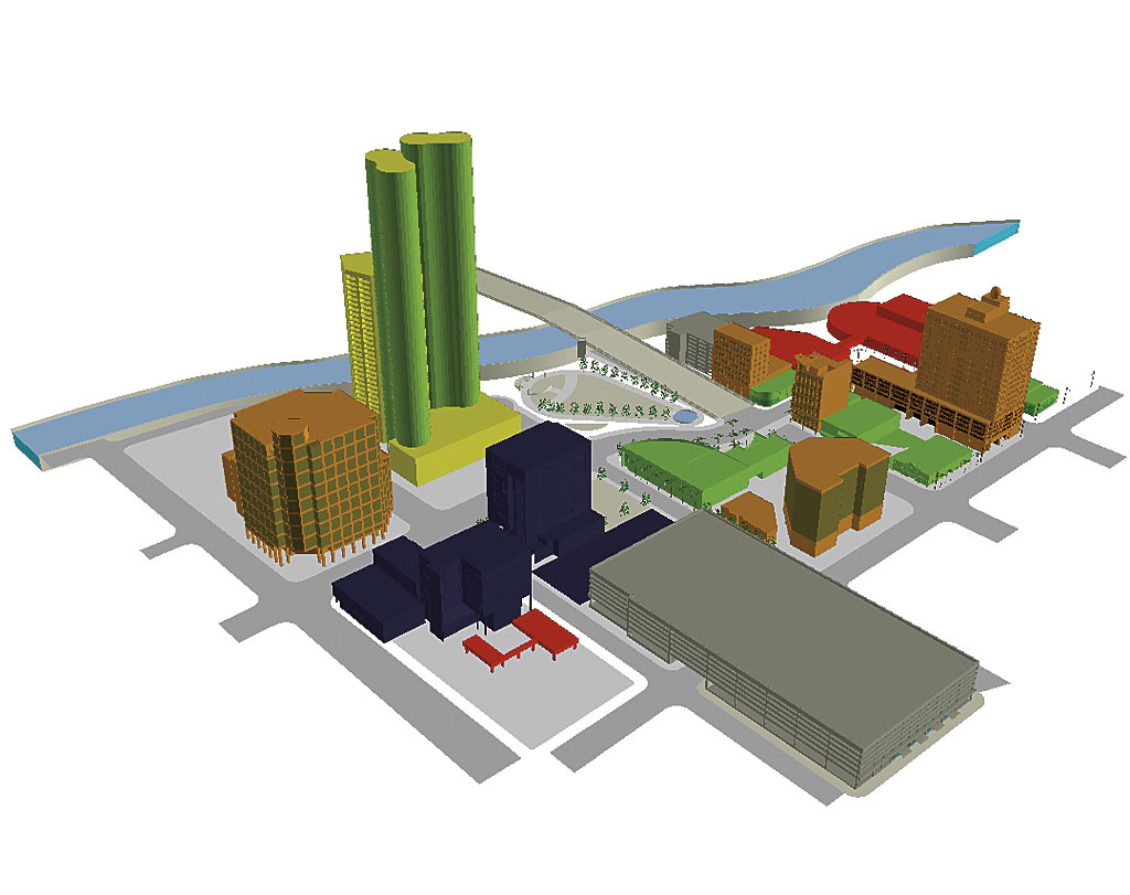
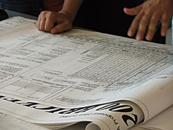 |
| Sample site plan |
The study area consisted of a nine-block section of downtown Fort Lauderdale that would be modeled for three time periods: 1928, 2006, and 2008. The base model year, 1928, was chosen as it represented the physical development of the city that resulted from the urban boom of the 1920s but stopped after the hurricane of 1928. Future visualization is based on the status of downtown Fort Lauderdale in 2006 with the addition of two new building developments that are scheduled to be completed by 2008.
Data Collection
The Fort Lauderdale Historical Society supplied maps, photographs, and images as well as comprehensive plans from the 1920s. A local surveying company, McLaughlin Engineering, provided early archival survey records of properties within the study area. Phone books and other historical documents were used to populate attribute tables with ownership, building use, and other information. Digital orthophotos from the Broward County Property Appraiser's Office were used for assessing existing conditions, and plans and visuals from developers were used for modeling future conditions. Measurements were taken using survey equipment, and buildings were scaled appropriately from digital pictures and architectural plans. In addition, two local developers, Stiles Corporation and Madfis Group, provided site plans and building data in AutoCAD (.dwg) format that was easily imported into SketchUp.
Modeling and Visualization
Compared with other modeling software, SketchUp's short learning curve and simple user interface provided a straightforward vehicle for three-dimensional modeling. The simple transition between two-dimensional surfaces and three-dimensional extrusions let users efficiently translate source data to three-dimensional buildings, roads, street furniture, and landscape elements. Users can rapidly develop three-dimensional models that are georeferenced, animate scenes, and produce shadow casting studies for proposed building.
For the purposes of the study, detail was limited to the first 18 feet above grade to capture the scene as the public visually experienced it at the pedestrian level. Less detail was developed above. This preserved the essential qualities of massing, building form, and scale without cumbersome memory requirements.

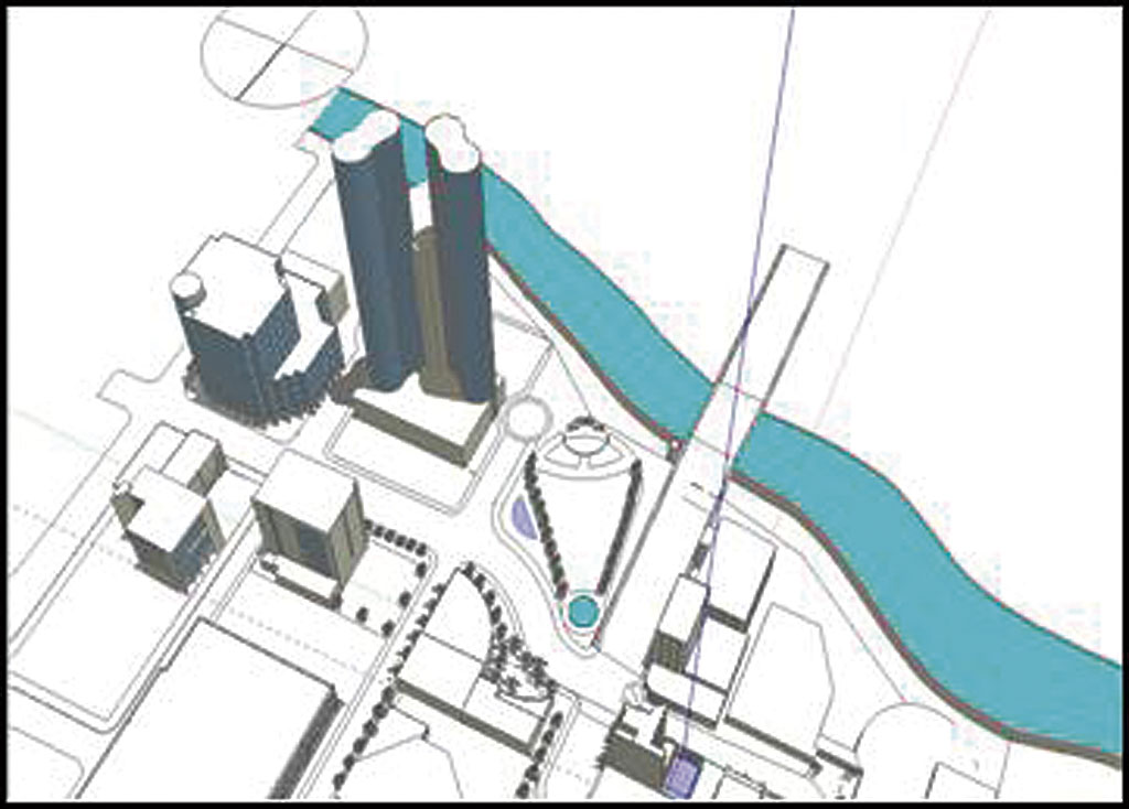
 |
| Shadow time lapse assessment in SketchUp |
ArcGIS enabled the input of building information, such as land use, address information, images, and occupancy levels, and the creation of basemaps. The ArcScene interface was used to visualize and superimpose the 1928 and 2006/2008 models to view potential changes in the urban landscape and enable fly-throughs of the downtown area.
The Next Steps
This experience provided insights to faculty participants for future joint exercises and courses. These insights included refinements of the modeling and database exchange techniques, expansion of the study area, and collaboration with the City of Fort Lauderdale's Planning and Zoning Department. More important, it highlighted the need to stay abreast or ahead of developments in three-dimensional GIS and related software and data exchange innovations so students, who are future GIS professionals, can create and use smart and interactive three-dimensional GIS applications for decisions related to quality places and spaces.
An article by Gary Smith and Joshua Friedman, "3D GIS: A Technology Whose Time Has Come," which appeared in the November 2004 issue of Earth Observation Magazine, provided a lot of optimism about a seamless three-dimensional GIS. The authors offered some very salient advice as well as noted the need to be selective in the choice of one's initial data development effort because "attempted all at once, such an undertaking might prove overwhelming" to users and computers.
Project Caveats and Advice
The FAU faculty and student team quickly discovered the following specific workflow steps and potential stumbling blocks that may be useful to keep in mind. Resources and references are also listed. Some of the critical steps for data and model exchange between ArcGIS and SketchUp include installing and activating appropriate software versions and plug-ins, bringing georeferenced vector data and orthorectified aerial imagery into SketchUp, and exporting from SketchUp as Esri geodatabase multipatch features (the ArcGIS three-dimensional data format).
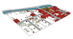
 |
| Building use changes from 1928 (upper image) to 2006 (lower image). |
It was necessary to devote several hours during the first week of the class to review fundamental three-dimensional modeling and SketchUp concepts and functionality (including components, groups, extrusion, creating three-dimensional geometry, creating and mirroring models, and developing models from correctly scaled aerial photos), GIS concepts (including spatial data structures, file formats, geodatabases, and map projections), and basic ArcGIS and ArcScene functionality (including data frames, layer properties, creating new shapefiles, joining tables, hyperlinks, multiple linking, and attribute tables). It is especially important to recognize that students who are used to working with the arbitrary coordinate systems of CAD-based drawings need to pay special attention to the georeferencing step.
The Crucial First Step: Software and Plug-In Installation
The following free plug-ins with installation instructions can be downloaded from the SketchUp Web site and were particularly useful to this project.
- ArcGIS plug-in enables users of the ArcGIS 3D Analyst extension to create highly detailed three-dimensional models and transfer them to an ArcGIS geodatabase for further analysis.
- Shapefile Importer enables SketchUp to read shapefiles (.shp) and convert them into three-dimensional models.
- Google plug-in enables SketchUp to seamlessly interact with other Google products, such as Google Earth, by reading and writing Google Earth model files in .kmz format and taking two-dimensional and three-dimensional snapshots from Google Earth.
Users should verify which versions of ArcGIS, the ArcGIS 3D Analyst extension, and SketchUp they are using before installing and activating these plug-ins.
Use spatially referenced features in ArcGIS and components in SketchUp. It is advisable to export spatially referenced GIS data, such as a building footprint and geoimages, to SketchUp before creating and grouping various components. SketchUp can also use the latitude and longitude of images obtained from Google Earth. When exporting shapefiles or features from ArcGIS to SketchUp, note that individual GIS features are exported as individual Sketch-Up components. See "SketchUp and ArcGIS: How They Work Together," a support document from the SketchUp site listed in the box at the top of this column.
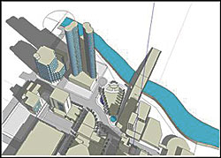
Before Finalizing the Geodatabase, Figure Out the Workflow
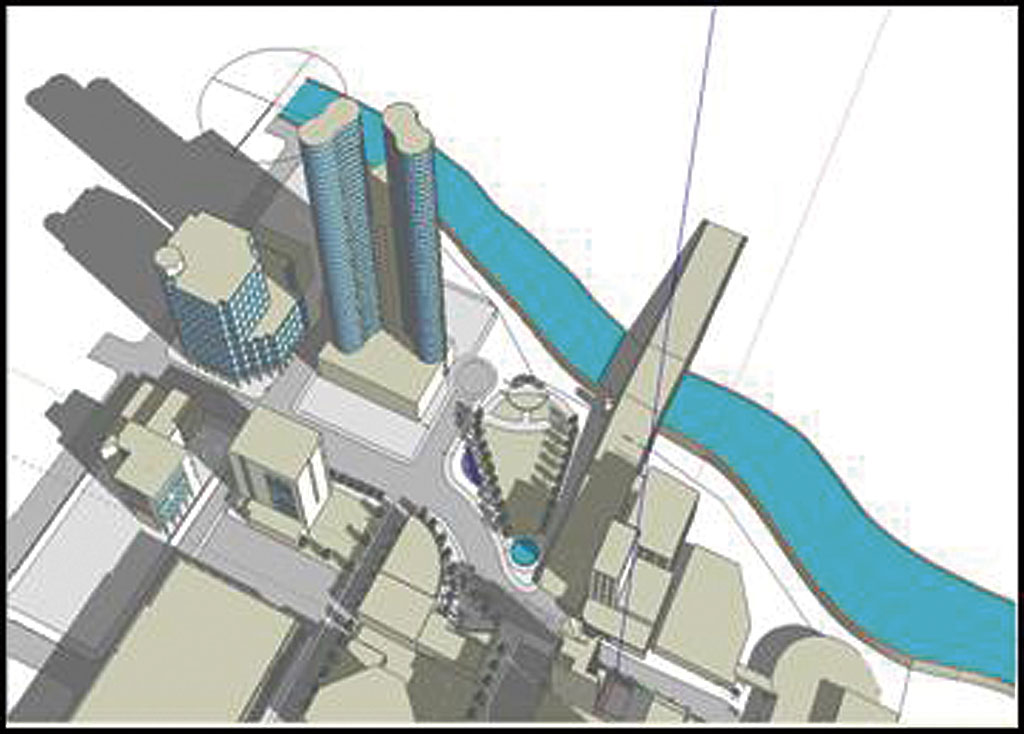
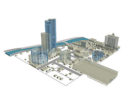 |
| Historical and current three-dimensional models superimposed in ArcScene |
When moving from SketchUp to ArcGIS, individually selected SketchUp objects are exported into an existing or newly created geodatabase in Esri multipatch format. For this project, the database was populated with attributes such as building name, address, use, and reference image name. The reference image name allowed multiple hyperlinking for viewing photographs of historic, current, and future buildings. This phase of the project required a geodatabase gatekeeper who exported the individual components that had been created by students.
The concept of seamless integration seemed to fall apart when trying to move from ArcGIS to SketchUp and back to ArcGIS, while keeping the attribute table intact. Items exported out of GIS do not retain their original attributes. Visit the online GIS forum on the SketchUp Web site forum for alternative ideas on working around this problem. An article, "SketchUp and ArcGIS: How They Work Together," is also available online and listed under the References section at the end of this article along with other useful information and guidance for first-time users.
For more information contact
Ann-Margaret Esnard
Director, Visual Planning Technology Lab
Florida Atlantic University
E-mail: aesnard@fau.edu
Acknowledgments
This collaborative effort would not have been possible without the time, resources, and effort of many individuals. The authors are grateful to the student team who operated in multiple roles as collaborators, learners, and teachers: Elizabeth Chang, Walker Dunn, Rory Ellis, Karen Friedman, Michael Green, Armand Ignelzi, Nicholas Meeks, Macline Pierre, and Geancarlo Ureta. The institutional support of Rosalyn Carter, the dean of the College of Architecture, and the technical support of Visual Planning Technology Lab staff members Asher Soldwedel and Jennifer Rosenberg were also instrumental.
About the Authors
Ann-Margaret Esnard is an associate professor of urban and regional planning and the director of the Visual Planning Technology Lab. She has more than 13 years of experience in GIS-related projects as well as curriculum development for various student and professional audiences.
Anthony Abbate is an associate professor and director of the Broward Community Design Collaborative at the College of Architecture, Urban and Public Affairs. A practicing architect, Abbate's experience encompasses all phases of design and project delivery in areas of architectural and urban design.
Aron Temkin is an associate professor and the director of the School of Architecture. His professional work in architecture emphasizes sustainable place making while his research explores digital modeling as a device for design refinement and animation as a device for temporal analysis of space.
Jaap Vos is an associate professor and chair of the department of urban and regional planning. He has worked on related projects that include the use of GIS for tracking and predicting types and location of development trends in downtown Fort Lauderdale and the creation of redevelopment scenarios for Overtown in Miami.
References and Resources
AtLast Software. 2002�2006. Mastering 3D Using SketchUp: Basic Training, Course No. 3HBA04.
AtLast Software. 2002�2006. Mastering 3D Using SketchUp: Intermediate Training, Course No. 3HIM04.
Meenar, M. R., and A. Ambrus. 2006. "Three-Dimensional Models Encourage Public Participation," ArcUser, April�June 2006, pp. 34�37.
Smith, G., and J. Friedman. 2004 (November). "3D GIS: a Technology Whose Time Has Come." Earth Observation Magazine.
Esri User Forum. Response by Rupert Essinger on Multiple Hyperlinking in ArcMap (support.esri.com/index.dfm?fa=forums.gateway, accessed May 2006).
GIS Forum on SketchUp Web page (forum.sketchup.com, accessed September 2006).
|