ArcUser
Spring 2012 Edition
Integrated ArcGIS Platform
ArcGIS 10.1 provides high performance, promotes collaboration
Esri continuously updates ArcGIS Online with new maps, imagery, and task services so users get the most current and accurate basemaps and GIS products available on the web.
This article as a PDF.
Learn more about what's new in ArcGIS 10.1.
ArcGIS 10.1 will change the way geographic information is managed by GIS professionals and accessed by their organizations. This complete GIS further integrates desktops, servers, mobile, and web applications and provides additional tools and infrastructure for extending the reach of existing GIS implementations. With ArcGIS 10.1, organizations can transition to next-generation GIS platforms without jeopardizing current GIS investments.
ArcGIS Online is now a fully integrated portal used by thousands of GIS users around the world to store and manage maps, data, and other geospatial information as well as access thousands of free maps, datasets, services, and tools. Esri continuously updates ArcGIS Online with new maps, imagery, and task services so users get the most current and accurate basemaps and GIS products available on the web.
ArcGIS Online for Organizations, a new subscription for ArcGIS Online, is a customizable, web-based system designed for managing an organization's geospatial content using cloud tools and infrastructure. It allows administrative control over data creation and access while making geographic information easily available both inside and outside the organization, enabling collaborative efforts.
At 10.1, ArcGIS for Server has a new, simplified, and high-availability architecture referred to as a site. An ArcGIS 10.1 for Server site includes a web server, web gateway, and GIS server for processing requests. With the web gateway, the site can be accessed through one common URL even though it may be composed of multiple machines. Running natively on 64-bit Windows and Linux operating systems, ArcGIS for Server provides users with high-performance web editing, map caching, on-the-fly analyses, and imagery exploitation capabilities.
Users have additional choices for deployment. ArcGIS for Server is fully certified on VMware and VCE's Vblock platform and can be deployed on Amazon Elastic Compute Cloud (EC2) on both Windows and Linux. Multiple GIS servers can be configured for the site and organized into groups called clusters. Each cluster can be configured to run a dedicated subset of services. For example, a cluster of servers with more processing power can be exclusively committed to running computationally intensive processes such as geoprocessing.
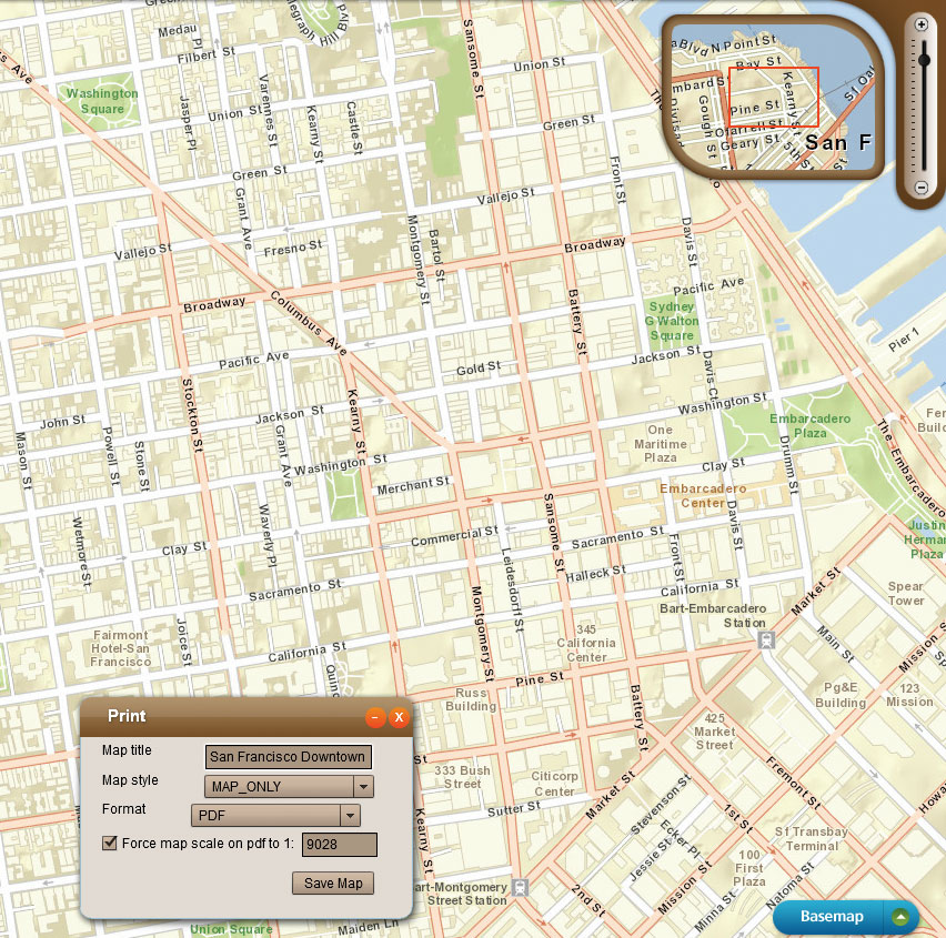
ArcGIS for Server includes new services, including a print service that allows users to produce high-quality, large-format PDF maps directly from web maps.
Once ArcGIS for Server is installed, services are immediately available through HTTP, eliminating the need for an existing web server and allowing users to get up and running quickly. The ArcGIS for Server site can also be integrated with an organization's web server using ArcGIS Web Adaptor. GIS servers can communicate with each other so workflows—such as asynchronous geoprocessing or map caching—can be distributed across servers to be more easily accomplished. Multiple GIS servers can be administered with minimum disruption to the site.
The new ArcGIS 10.1 for Server architecture is cloud-friendly. ArcGIS Server Cloud Builder for Amazon Web Services, a new Windows-only desktop application, lets administrators build and maintain ArcGIS for Server sites on Amazon EC2, create templates (e.g., custom sites), back up sites, or delete sites without logging into the Amazon-hosted machine. GIS servers can still be administered via Amazon Web Services Management Console for more fine-grained control over the site.
ArcGIS for Server includes new services, including a print service that allows users to produce high-quality, large-format PDF maps directly from web maps. Along with the ability to generate sophisticated GIS and mapping services with Standard and Advanced editions, all editions of ArcGIS for Server will provide simple mapping capabilities from a spatially enabled database.
GIS professionals will find this release of ArcGIS for Desktop to be the most empowering GIS authoring environment to date. Any GIS resource—including maps, imagery, geodata, and tools—can be delivered as a web service on both ArcGIS for Server and ArcGIS Online. Desktop users can easily package maps and layers and make that content available to staff, stakeholders, partners, or the public via online groups while maintaining complete control and ownership of this content.
At 10.1, developers gain even greater access to the ArcGIS system via improved APIs and software development kits (SDKs) for web and mobile applications, configurable viewers, and the new ArcGIS Runtime. With ArcGIS Runtime, developers can create and deploy focused, fast, stand-alone GIS applications for desktop users. The runtime is a small, lightweight deployment designed for both desktop and cloud development that does not require installation and can be run directly from a CD. In terms of its capabilities, ArcGIS Runtime fits between ArcGIS Engine and ArcGIS Web Mapping APIs.
Mobile developers can also create custom business applications using ArcGIS Runtime SDKs for iOS, Android, and Windows Phone devices. These apps can use the powerful mapping and geocoding capabilities available from ArcGIS for Server and ArcGIS Online. Apps can be deployed to the enterprise or the public via the App Store and Marketplace. A free ArcGIS application, available for download on all major mobile platforms, lets users explore map content, collect and edit GIS features, and use sophisticated geoprocessing tasks.