ArcUser
Spring 2012 Edition
Responsiveness and Reliability
Kentucky Geological Survey benefits from ArcGIS for Server
By Matthew DeMeritt, Esri Writer
This article as a PDF.
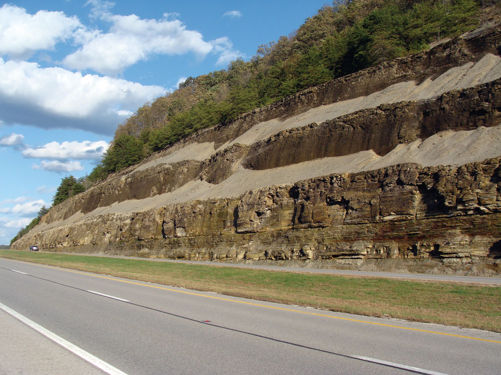
The Devonian Ohio Shale, exposed along Interstate 64 in northeastern Kentucky's Rowan County. This shale is the source of most of the natural gas production across Kentucky. Its high organic matter content, commonly 5 to 10 percent, gives the shale its nickname, black shale.
Geological surveys aren't just for geologists. Whether at the national or state level, geological surveys collect and archive land information and serve it to many different constituencies.
In Kentucky, practically every sector from petroleum to transportation needs information about land and location. They obtain that critical data from a website created and managed by the Kentucky Geological Survey (KGS).
Last year, KGS completed the migration of its KGS Geologic Map Information Service from ArcIMS to ArcGIS for Server, greatly improving rendering performance, expanding access to off-site information, and refining its development and maintenance processes.
Paper to Digital
When Esri introduced ArcIMS in 2000, it delivered digital maps online, replacing many paper map requests. Soon after, KGS adopted ArcIMS to serve its customers' mapping needs and reduce its paper map workflow.
ArcIMS gave KGS the opportunity to demonstrate geospatial technology to its constituents and reveal the benefits of digital maps over physical maps—something only GIS professionals had understood until then. Within a simple web browser, ArcIMS emulated the experience of overlaying plastic sheets onto physical basemaps.
"Our constituents quickly realized how much easier it is to click a check box to populate a basemap with data rather than fumble with large plastic sheets to get the same result," said Doug Curl, GIS programmer at KGS. "It didn't take long for them to accept the new browser-based method, which naturally resulted in requests for paper maps dropping significantly." Esri's first Internet map server provided the transitional technology KGS needed to acclimate its users to a more efficient digital workflow.
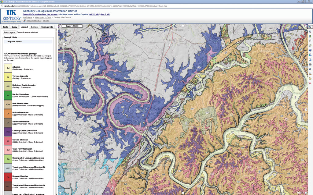
KGS detailed geologic map of the state, including formations (colored polygons), faults (dark lines) of an area in central Kentucky, and a customized legend of map units
In 2004, KGS completed a project to digitize every 1:24,000 geologic alquadrangle in Kentucky to make one of the most detailed state geological maps available. KGS wanted to ensure its constituents could use all the information included in the map down to the smallest scale.
"That map is our core service," said Curl. "We captured pretty much everything that was on a 1:24,000 quadrangle [including all faults and geologic features and descriptive information about the geologic units] and put it into a database." All tabular data can be searched and displayed at small scales on a digital map. This is helpful, for example, when natural resources personnel need to present information on water wells or drill points in a small area.
Cut Down on Slowdown
As more of KGS's constituents learned about the site, traffic steadily increased. Each new wave of visitors jammed bandwidth and progressively added minutes to simple map display.
"Initially, few users complained about slow map refreshing because it was still considered new during those years," said Curl. "But as user expectations rose—mainly due to fast consumer mapping applications that users had become accustomed to—we began to get requests for speedier rendering."
Maintenance also became a double-edged sword. As Curl's team added new functionality to optimize its system, it had to frequently reboot ArcIMS, increasing server downtime and further hampering site performance. Fortunately, KGS anticipated its customers' wish list and had been planning a transition to higher technology. "We not only wanted to deliver speedier access to our core map and external services, but we also wanted to reduce our development and maintenance time and increase stability," said Curl.
Access to External Services
The KGS geologic map site is data intensive. It includes high-resolution vector geologic maps that depict the locations of hundreds of thousands of wells and other natural features. In addition, KGS relies on other state agencies for many layers of statewide basemap data.
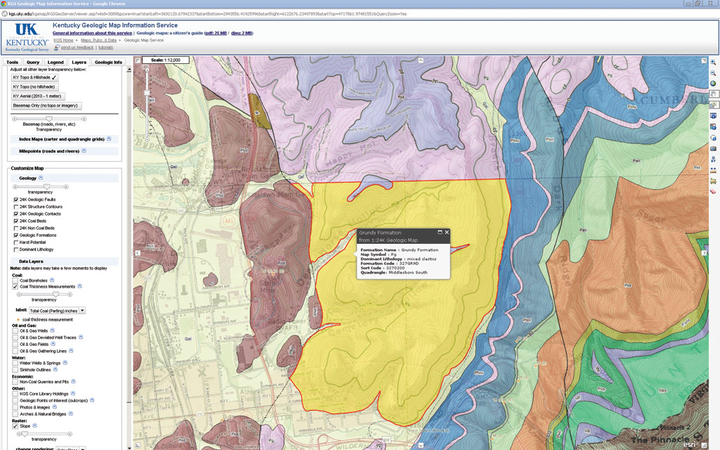
Map showing coal thickness measurements of the Middlesboro and Cumberland Gap area in southeastern Kentucky
When using ArcIMS, KGS had to acquire, maintain, and update its own copies of these basemaps whenever a state agency acquired new data. This required transferring terabytes of data between agencies and importing this data into ArcSDE. By using streaming map services in ArcGIS for Server, KGS now can provide various basemap data via other Kentucky agencies' external published services and not have to worry about the design and maintenance of those layers, and it always has the most current version of the basemap without having to acquire and maintain the data. This allows KGS to focus on its own data.
Code Reduction
ArcGIS for Server out-of-the-box functionality eliminated much of the time Curl had spent coding functionality in the system. With ArcIMS, operations had to be programmed as separate tools. Curl also received user requests for other functionality, which he had to create from scratch.
"Since map navigation and other tools are programmed into ArcGIS for Server, my coding work has dropped significantly and freed time for me to address other priorities," said Curl. "The expanded capabilities included in ArcGIS for Server also sufficiently meet our constituents' needs, which has resulted in fewer user requests for new functionality."
Since migrating all its components over to ArcGIS for Server last year, KGS users experience quick drill downs into maps no matter how high the site traffic. Its on-site map service performs with exceptional speed and smoothness and streams external services with the same quick performance. KGS also saw a dramatic reduction in downtime, as user requests could be done on the fly and without the need to reboot the system after each change.
"The site since the migration far exceeds what we were able to do with ArcIMS," said Curl. "Providing the ability to click a data service within our site and have it instantly render on a map within the same browser—that's important for the user. Having less coding to deal with eased the development process and made our lives easier in turn."