|
The Magazine for
Esri Software Users
|
|
|
Map Making with Styles
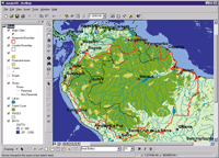
ArcMap is the tool for integrating data and using maps in ArcInfo. Data from shapefiles, coverages, tables, CAD drawings, images, grids, and TINs can be integrated using ArcMap. Many powerful tools for creating, viewing, querying, editing, composing, and publishing maps are available through the ArcMap interface. Styles, one of these tools, makes it easier than ever to present the results of analysis.
What is a Style?
A style is a defined set of symbols and map elements that describes not only how data is drawn, but also the appearance and placement of map elements, symbols, and other cartographic additions to the map. Styles can be accessed directly from the interface in ArcMap by choosing Tools>Styles from the menu. This provides access to dialog boxes for managing, referencing, and exporting map styles.
Map templates and feature layers work with styles to help users quickly produce maps that communicate effectively and are visually pleasing. Styles can help maintain consistency in the choice of symbols, colors, and patterns and in the methods of rendering distributions, relationships, and trends for an organization or an industry. Sharing styles within an organization can improve productivity and standardize the maps an organization produces so they will be more easily understood by map users.
Use Industry or Custom Styles
ArcMap comes with a robust collection of generic symbols and map elements designated as the Esri style as well as a wide range of industry-specific styles. Industry styles are used to make maps that convey the right message for a specific application such as utilities, transportation, or local government. In addition to the styles that come with ArcMap, custom styles can be easily created by modifying map elements and symbols while designing a map and saving these modifications to a style. Exporting map styles saves map elements and symbols from many styles into a single style.
Editing map symbols is intuitive and direct.
Simply click on the desired item in the table of contents to bring up the Symbol Selector. The symbols from referenced styles can be previewed and/or selected. Clicking on items in the Options section of the dialog lets the user change the color, size, and angle of the currently selected symbol. Clicking on the More Symbols button brings up a list of all the available styles so additional styles can be referenced. Extensive revisions of the symbol can be made by clicking on the Properties button and using the Symbol Property Editor. Modified symbols and elements will be automatically saved to the user's personal style but can be moved to another style using the Style Manager.
Styles can be added or removed anytime during an ArcMap session. The list of styles available can be modified so that only selected styles are accessible to users. In ArcMap, anything that is drawn on a map-a symbol, map element, or graphic-is copied to the map document so the originally referenced styles aren't needed to open or draw the map again.
Managing Styles
The Style Manager helps organize styles and their contents. 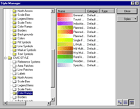 Symbols and map elements can be cut, copied, pasted, renamed, and modified in the Style Manager. The user's personal style, the Esri default style, and any other styles that have been referenced and are therefore available to the map are displayed in the Style tree. The contents of the symbol and map element files associated with a style can be previewed by opening folders in the Style tree. Symbols and map elements can be cut, copied, pasted, renamed, and modified in the Style Manager. The user's personal style, the Esri default style, and any other styles that have been referenced and are therefore available to the map are displayed in the Style tree. The contents of the symbol and map element files associated with a style can be previewed by opening folders in the Style tree.
This introduction to styles demonstrates the powerful and easy-to-use tools available in ArcMap. Use styles, along with map templates and feature layers, to streamline map production and tailor maps to specific audiences.
| |
