ArcUser Online
| Datums by Mike Price, Esri |  |
|
When was the last time you thought about what datum the data you were using was in? Perform analysis using data sets created in different datums or even display them together and you won't like the results. The same features in two street centerline themes or coverages may appear offset by many meters or feet. Fire hydrant points collected with GPS appear located in parking lots or inside buildings instead of out by the curb. GPS coordinates acquired by hikers show their position half way up a very steep cliff instead of on the mapped trail below. These are all very real examples caused, in large part, by using data sets lacking a common datum. What's a Datum? Prior to satellite mapping technology, the best approximation of the shape of the earth was the mathematically calculated geoid, which evolved into slightly flattened spheroids or ellipsoids. Geographic coordinate systems use a spheroid to calculate positions on the earth. A datum defines the position of the spheroid relative to the center of the earth. As surveying technology improved and data acquisition increased worldwide, the mathematical formulas and the related parameters used to describe the shape of our irregular earth continually improved and were expressed in spheroids such as Everest 1830, Airy 1849, Clarke 1866, Clarke 1880, and Krasovsky 1940. Until recently, a comprehensive knowledge of--or even much interest in--datums was limited to mathematicians, geodesists, and geographers specializing in cartography. Field surveying was performed on a local basis using traditional mechanical, optical, and laser equipment. Typically, local coordinate systems were developed and vertical and horizontal control were derived from a local frame of reference or datum. For those outside the field of cartography, map projections were often an issue, but datums, those absolute global frames of reference, were not. Developing Datums As mapping expanded globally, cartographers established coordinate reference frameworks that helped standardize mapping activities across wide areas. The resulting datums were typically limited in extent and were tied to an origin point on the earth's surface. The North American Datum of 1927 (NAD27) is a classic example of an early, local earth-surface-based datum. The spheroid NAD27 uses Clarke 1866 that originates at a surface point at Meades Ranch, Kansas. Many NAD27 control points were calculated from observations taken in the 1800s. The calculations were done manually, in sections, over many years, and errors vary from station to station. Getting the Big Picture More than 30 years ago, satellites began acquiring remote imagery. As GPS, a satellite-based location system, matured and became accessible to the public, the need to extend and better define the earth's spheroid and associated datums became more pressing. In 1980, a new spheroid, the Geodetic Reference System (GRS80), was developed from satellite measurements. Instead of defining the earth from surface measurements linked horizontally and related vertically to mean sea level, this new mathematical approximation was derived from a point located out in space. This spheroid and its associated datums define the earth's shape by measuring and triangulating from an outside perspective and use the mass center of the earth as an absolute origin. Using the GRS80 spheroid, new datums were developed both regionally and worldwide. The North American Datum of 1983 (NAD83) and the World Geodetic System of 1984 (WGS84) are examples of these new datums. Worldwide, all GPS measurements are now based on the WGS84 datum. 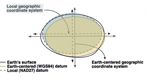
In addition to satellite positioning, the development of GIS and the Web have significantly increased public access to and use of spatial data. As GIS use has increased, more nongeographers are manipulating geographic data. The Web has made spatial data in a variety of projections and datums far more widely available. Both the availability and diversity of data make understanding datums an important issue for GIS users. Using data created in both old and new datums together can be challenging. Points calculated using early methods seem to shift by tens, even hundreds, of meters when recalculated in modern space. While the math and science behind spheroid definition and datum transformation is complex, GIS users must recognize the importance of improving data collection, registration, and documentation methods so that the analysis of spatial data will continually improve. It is essential to carefully study each piece of spatial data--whether vector, grid, triangulated irregular network (TIN), or image data--to determine the way the data was obtained, how it is displayed in its native format, and that it correctly displays at the largest practical scale. ArcInfo 8.1 and ArcView 8.1 are designed to recognize, interpret, and correct for spheroid, datum, and projection differences. Traditional ArcView GIS 3.x and ArcInfo 7.x software also accommodate these differences, although not "on-the-fly." In every case, it is important to understand the metadata behind data and to properly record differences in geometric parameters. The answer to the question "Who needs datums?" is you do. To avoid time-consuming and possibly costly data alignment issues, GIS users need a basic understanding of datums and an awareness of the datums associated with the data sets they use.
|