ArcUser Online
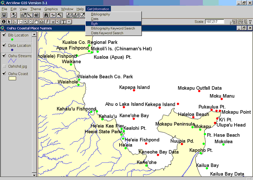
Monitoring the health of coral reefs has been identified as a major priority, both in the United States and internationally. The application of GIS provides managers and researchers with an invaluable tool to address fundamental scientific and management questions concerning the past, present, and future status of Hawaii's coral reefs. A major shortcoming of existing systems has been a disconnect between the extensive spatial data and bibliographic information and historical data available from a wide range of sources. Whenever a question arises in a given geographic area, the researcher or manager must uncover all relevant information for that area. Thus, there is a critical need to quickly and effectively identify and access pertinent scientific literature within a given spatial framework. Defining the ProblemScattered reports, files, and bibliographies can contain vital information on various aspects of coral reefs. Much of the information is found in "gray" literature reports that are not cited in standard literature and are rarely disseminated to the larger scientific community. Electronic bibliographies using different search engines and formats exist in a variety of noncompatible systems, but there is no single tool that allows for a simple search based on a specific geographic location in Hawaii's coral reef and near-shore ecosystems. This situation makes any in-depth review of the literature for a given site in Hawaii time-consuming and far from cost-effective. Biologists at the USFWS office use ArcView 3.x to analyze environmental data for various near-shore regimes surrounding the islands of Hawaii. Nonspatial data is maintained in Microsoft Access. Locating supporting literature for studies and evaluation of specific areas requires that biologists perform time-consuming literature searches and visit many offices, libraries, and organizations to access the identified materials. A group of concerned biologists and librarians decided to develop a management tool that would simplify this process. Because one of the constraints adopted for the project was that the new system would use software that staff were already familiar with and had ready access to, this meant finding a solution that took advantage of the features of Microsoft Access and ArcView 3.x. A successful solution would provide
Project DescriptionTo address the problem, a multifunctional database was developed that merges coral reef bibliographic references with the metadata from environmental datasets. This demonstration project focused on the Island of Oahu because considerable data--well-defined monitoring sites and literature--was readily available for this area. However, the database can be expanded to include other islands of Hawaii and the Pacific to support other federal and international conservation management concerns. Four types of datasets were developed for this project. ArcView DataShapefiles and location names for the Island of Oahu were obtained from the Hawaii Statewide GIS Program Web site (www.state.hi.us/dbedt/gis/). Tables were developed that contain bibliographic citations, metadata information, and map location names. A table was also created that allows for one-to-many linking so that ArcView 3.x could identify single records that referenced more than one location. Access DataRelational tables and search forms was developed in Microsoft Access 2000. The tables contain related information for bibliographic citations, bibliographic record information, and map location names. The forms let users search for and edit existing data and input new data. Periodically, the database is exported in dBASE (DBF) format and used to update ArcView 3.x. Bibliographic DataThe citations, abstracts, and comments commonly used by USFWS biologists come in a variety of formats--HTML, word processing, and print. Consolidating this information into a centralized database greatly simplified the identification process for biologists and managers. When available, comments from local biologists were added to the records. Continued on page 2 |