ArcUser Online
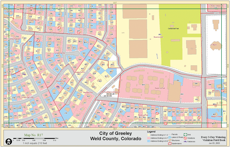
For the city of Greeley, located 50 miles northeast of Denver, lack of both snow pack in winter and rain in spring, combined with above average temperatures all summer, stretched the water resources for its citizens to the limits. Runoff, stored in reservoirs, did not supply enough water to meet the city's outdoor irrigation demands. To ensure some water availability in coming years, the city set a goal of reducing water use by 15 percent for its 75,000 citizens. City water planners felt that water savings would be best achieved by reducing outdoor irrigation, which constitutes approximately 70 percent of each Greeley household's total use. In July 2002, pursuant to this water reduction, the city council voted to require that citizens limit outdoor irrigation to every third day until the end of September. Home addresses would determine the days that residents could irrigate. Working for Equitable DistributionWhile preparing the new policy, the Water Resources Division worked closely with the Engineering Division to outline the address distribution. City staff was concerned that if address numbers were not evenly distributed among groupings, a large number of homes in the same pressure zone would be using water at the same time resulting in reduced water pressure. To ensure that the new policy would not adversely affect the water pressure system, the Water Resources Division used GIS to analyze address distribution within each pressure zone.
The author, a water resource analyst, used ArcMap 8.2 to develop an address distribution that ensured adequate pressure throughout Greeley's water system. To evaluate the best grouping of addresses, he used the definition query in the properties menu and pulled out address groups from the parcels coverage. After performing a selection by location on all of the addresses in a group that were completely in a specific pressure zone, he was able to use the statistics function with the parcel polygon layer table to determine how many parcels were selected in each pressure zone. After several trial and error scenarios, the best solution grouped addresses ending in 1-3, 4-7, and 8-0. Using these groupings produced the closest to a 33 percent breakout of addresses per pressure zone. Using the GIS to both visualize and analyze the address distribution gave engineers and managers a tool that provided the necessary data for a sound decision. Historically the Water Resources staff had relied on ASCII- formatted data exported from the city's utility billing data to make decisions on address distribution. While the ASCII query method could provide fairly accurate results, the GIS process cut the analysis time in half and graphically illustrated the results. Mapping Out InfractionsTo help enforce the new city irrigation ordinance, the author worked with Greeley's water conservation specialist, Ruth Quade, to track, report, and graphically display violators. When a watering violation was reported to the city, the date, time, type, and location of the violation was entered in a Microsoft Access database. Using the join function in ArcMap, the Access file containing up-to-date violation information was linked to the parcel coverage, allowing mapping of the reported violations. The author set up a 1:210-scale, 11" x 17" map book using the MapBook Developer's Sample for ArcMap from ArcObjects Online so that he could quickly print sheets the violation patrol could use to confirm addresses, check for prior violations, and note those homes given variances to irrigate on a more regular basis. The map book sheets also served as a useful tool to limit overlap on patrols. According to Quade, having all the data in a spatial format "not only saved time, more important, [it] averted mistakes because we weren't having to cross-check different sources, databases, and spreadsheets." The effort made Greeley a model for other Colorado front-range communities. From the initial investigation of address distribution to violation patrols, GIS was an invaluable tool that allowed city staff to propose and enforce a new policy that ultimately conserved 325,829,000 gallons of water although the author spent only 40 hours on the project. For more information, contact Sean Cronin, Water Resource Analyst About the AuthorSean Cronin, water resource analyst with the city of Greeley, Water Resources Division, received a bachelor's degree in earth science with a concentration in environmental science and GIS from the University of North Carolina at Charlotte. He worked as a natural resource agent for the Gaston County North Carolina Cooperative Extension Service using GIS to analyze wellhead protection areas and potential surface water contamination sources in local watersheds. As a GIS technician for the city of Greeley's Public Works Department, he maintained more than 300 datasets and created an ArcView training program for city employees. For the past three years, he has worked in the Water Resources Division using GIS to delineate water resource systems and incorporates nonspatial datasets to evaluate the efficiency of the water resource system. |