ArcUser Online
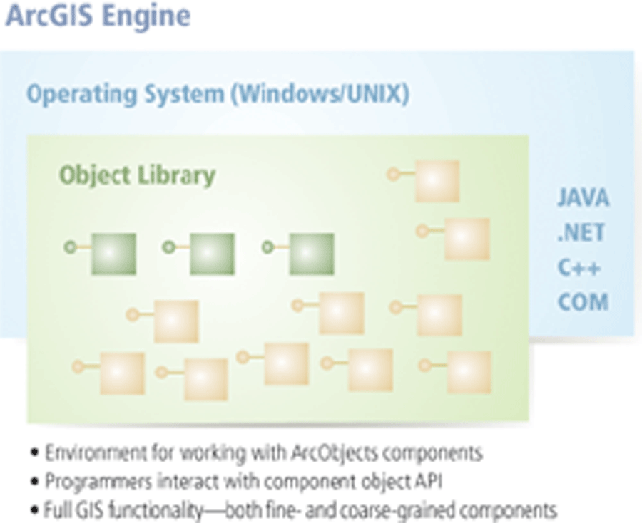
Metadata has been used for centuries in the margins of maps and charts. Used within a GIS, standardization of metadata becomes increasingly important; it provides users with an understanding of geographic information and allows the exchange of "data about data." Metadata standards identify and standardize the metadata user communities need to manage, share, and reuse their geographic data and promote global interoperability. Recognizing that metadata support is crucial to building a strong spatial data infrastructure, Esri has supported standard metadata representations and developed metadata servers that enable users to discover and evaluate data that originates from multiple sources in a variety of formats. ArcView, ArcEditor, and ArcInfo, the ArcGIS Desktop products, allow users to create, manage, and edit metadata stored in an XML representation of Federal Geographic Data Committee (FGDC) Content Standards for Digital Geospatial Metadata or of the ISO 19115 Metadata Standard. With ArcIMS Metadata Services, users can create a central, online metadata repository for publishing and browsing metadata over the Internet. The metadata documents stored as ArcIMS Metadata Services can then be accessed using a client that communicates using ArcXML. Examples of these clients include ArcCatalog (the ArcGIS Desktop application for managing data); the ArcIMS Metadata Explorer (a set of JavaServer Pages that can be used to build a customized, browser-based application for searching for metadata); and Z39.50 and ISO 239.50 clients (national and international standards, respectively, that define protocols for computer-to-computer information retrieval). Going MainstreamThe migration of GIS from projects to mission-critical business processes at the enterprise level, coupled with an emphasis on delivering a better return for investments in GIS technology and databases, continues to drive improvements in interoperability. Truly open systems allow sharing of geographic data not only with other GIS technologies but also with non-GIS applications that operate on different platforms. The ability to scale applications to support a wide range of implementation scenarios from the individual to a large organization requires customization and extension of capabilities using industry standard development tools. Initially, the open development environments available with SDE let developers use MapObjects with popular Windows development environments, such as Visual Basic and Visual C++, to create custom applications. The ArcInfo Open Development Environment (ODE), ARC Macro Language (AML), and Avenue also provided methods for extending and customizing GIS software. The release of ArcGIS greatly enhanced the extensibility, customization, and integration of GIS with non-GIS applications. ArcGIS Desktop is built using the ArcObjects framework. ArcObjects is a collection of software components with GIS functionality and programmable interfaces that is based on the COM architecture. ArcGIS applications, such as ArcMap, can be customized using the built-in Visual Basic for Applications (VBA) scripting language or COM-compliant programming languages such as Visual Basic, Visual C++, or Delphi. ArcObjects can also be used to build stand-alone applications or to add GIS functionality to existing, non-GIS applications. As GIS has become integrated with the mainstream IT environment, interoperability with industrywide IT standards, as well as GIS standards, has taken on greater importance. Esri has worked to ensure compatibility and interoperability with enterprise systems such as enterprise resource planning (ERP), customer relationship management (CRM), enterprise application integration (EAI), work management systems, and decision support systems. Increasingly, GIS software is deployed in these types of multiuser environments. In these environments, spatial data is accessed from a variety of platforms and devices. Consequently, GIS must support platform-independent solutions that can be implemented for different server hardware, operating systems, networks, databases, development tools, and desktop applications in addition to Web and mobile clients. The ability of GIS to function in this sort of heterogeneous environment represents significant evolution from the situation in the mid-1990s. At that time, GIS was closely tied to native, proprietary spatial data structures. Although these early nonrelational file structures were optimized for fast access and relatively easy distribution between sites using the same GIS vendor software, the ability to share data among users across organizations was limited by network protocols and data sharing between organizations with different GIS vendor systems or business applications. Evolving GIS Structures
Gradually, GIS evolved into georelational structures that allowed related attribute data to be stored in a relational database that was linked to the file-based spatial features. However, the georelational format had limited scalability. The dual data structure (i.e., spatial features stored in proprietary file-based format with attributes stored in a relational database) also meant that the GIS could not take full advantage of relational database features such as backup and recovery, replication, and fail-over. In addition, supporting large data layers required the use of complex tiling structures to maintain performance, and sharing spatial information with other core business applications was still not very feasible. The development of the geodatabase enabled spatial data to be stored in relational databases. Spatially enabling databases opened a new era of broad scalability and made the support of large, nontiled, continuous data layers possible. When these databases were combined with client development environments that could be embedded within core business applications, the sharing of spatial features with core business applications, such as customer management systems, became a reality. With spatially enabled databases, organizations could begin eliminating organizational spatial data islands and implementing enterprise GIS. Data Model DevelopmentIn addition to geodatabases, the development of generic data models represents a fundamental move toward a higher level of interoperability. Esri's objective in creating data models for various industries, such as telecommunications and transportation, and applications, such as basemap and biodiversity, is to build designs that can be used by any GIS organization, regardless of the software being used. Each model has been developed by a consortium of domain expert users and business partners using accepted standards. These models support migration from existing file-based systems and are designed to be extensible, flexible, and easily adaptable to the requirements of specific organizatons. Continued on page 3 |