Study Yields Robust Carrying Capacity Model
By Steven G. Parker, URS Corporation, Tampa, Florida
The Florida Keys, a 106-mile long chain of more than 1,800 islands, constitutes the third largest barrier reef ecosystem in the world. Ecologically rich and environmentally sensitive, the Keys were designated as an Area of Critical State Concern by the state of Florida in 1974. The goals of this designation were "�to conserve and protect the natural, environmental, historical, and economic resources; the scenic beauty; and the public facilities within the Area of Critical Concern."

The ruling transferred all local review and approval rights to the Florida Department of Community Affairs (DCA). Following this designation, a new comprehensive plan and corresponding land development regulations were approved. In 1996, further revisions resulted in a final plan and the adoption of a "carrying capacity approach" to growth management. In this same year, the state of Florida mandated a study to address the carrying capacity of the Florida Keys and support comprehensive development plan amendments. In early 2000, DCA awarded the Carrying Capacity Study to URS Corporation with funding provided by the United States Army Corps of Engineers.
The Study
The Florida Keys Carrying Capacity Study (FKCCS), begun in April 2000, was completed in March 2003. During this three-year period, three work products were provided to DCA. The final deliverable consisted of two land use planning models: the Routine Planning Tool (RPT) and the Carrying Capacity Impact Assessment Model (CCIAM), the primary GIS model.
Overview of the CCIAM Process
RPT is a lightweight ArcIMS application for publishing the results of different land use mix scenarios. CCIAM is a more comprehensive application built with ArcGIS 8.1 (ArcInfo license) customized using Visual Basic for Applications (VBA) programming and Microsoft Access personal geodatabases. CCIAM also uses Microsoft Excel 2000 and the ArcGIS 8.1 Spatial Analyst extension.
CCIAM users include planners from Monroe County, the South Florida Regional Planning Council, and DCA as well as other stakeholders involved with the county's comprehensive planning process. This application can be easily modified to accommodate the land use planning needs of other agencies and jurisdictions. CCIAM evaluates the end state effects of land use scenarios on the natural and social systems of the Florida Keys to determine the ability of the Florida Keys ecosystem, and various portions thereof, to withstand the impacts of additional land development activities. Conceptualizing, designing, and creating CCIAM was a monumental effort.
The Role of URS and GIS
URS, as the prime consultant, oversaw the army of subconsultants that supplied multidisciplinary teams of experts in land use planning, socioeconomic and fiscal analysis, human infrastructure, pollutant load modeling, terrestrial ecosystems, and species habitat. URS collected, organized, reviewed, and prepared all geospatial data while the subconsultants developed enormous amounts of ancillary data and built discipline specific mathematical models and tables that were programmed into CCIAM by URS.
URS compiled spatial and nonspatial data into several different source input file formats including ArcInfo coverages, grids, and lookup tables. Taking advantage of the robust functionality of ArcObjects, the SQL query environment in Access, and the COM-compliant development platform of ArcGIS, URS was able to integrate and manage the many components that make up CCIAM.
| CCIAM Inputs |
Count |
|
CCIAM VBA Statistics |
Count |
| Coverages |
32 |
|
Modules |
31 |
| Grids |
18 |
|
Forms |
32 |
| Excel Files (.xls) |
12 |
|
Procedures/Functions |
337 |
| Access Geodatabases (.mdb) |
5 |
|
Lines of Code |
~ 30,000 |
| Lookup Tables |
63 |
|
Object Libraries Referenced |
17 |
| Layer Files (.lyr) |
41 |
|
|
|
Table 1: CCIAM inputs and VBA statistics
For example, the Hurricane Evacuation model was developed as an Excel macro and provided to URS for incorporation into CCIAM. Using the Microsoft Excel Object Library reference, the program opens the Hurricane Evacuation Excel spreadsheet, updates the inputs, and runs the Excel macro, then copies the output (i.e., evacuation time) from the appropriate cell reference and places the answer in an Access table. Another significant feature of CCIAM is its ability to summarize attributes into tables using complex SQL statements. Without SQL query capabilities provided by the Access Jet database engine, this application would run more slowly.
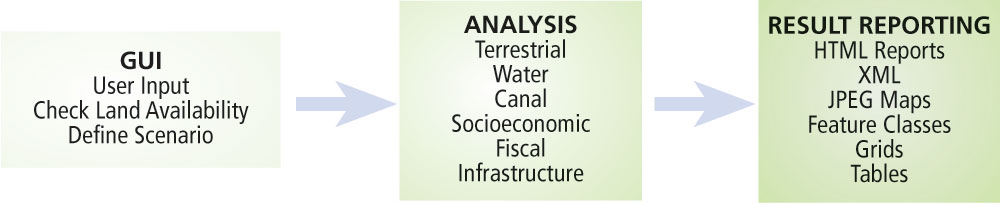
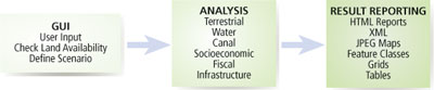
CCIAM is executed in three main steps:
- The land use scenario and accompanying land use coverage are defined using the graphical user interface (GUI).
- The results from the scenario are analyzed and compared to current conditions (i.e., in 2000).
- Results are reported in maps, feature classes, tables, grids, Excel spreadsheets, ArcMap layer files, and HTML files.
Defining the Scenario
The GUI enables users to create a land use scenario. The land use (parcel) coverage serves as the starting point for all scenarios. Selecting parameters from multiple forms, the user can create simple or complex land use scenarios. The user can also select wastewater and storm water treatment types as well as a hurricane category. The hurricane category is used to calculate a hurricane evacuation response time for a given scenario.
The degree of complexity in these scenarios can vary greatly. A simple land use scenario might include selecting all vacant residential parcels in Key West and developing these parcels into residential units with two dwelling units per acre and using a category two hurricane.
A complex scenario might involve selecting the implementation of Keys-wide wastewater and storm water master plans and a category three hurricane with evacuation outbound lanes increased to three from Key West to Stock Island. All commercial parcels designated as Office in the Lower Keys would be located within 100 feet of United States Highway 1, and structures with an age greater than 20 years old would be selected and changed to Retail with a maximum limit of 100,000 square feet of redevelopment.
Continued on page 2
|