Modernizing the Geographic Data Infrastructure
In January 2001, the United States Geological Survey (USGS) embarked on a decade-long effort that will provide unprecedented public access to high-quality geospatial data and information. The agency's recognition that digital geographic information is vital to the economic health and security of America has led to the development of The National Map, an online, interactive map service that can be accessed using nothing more than a Web browser.
 |
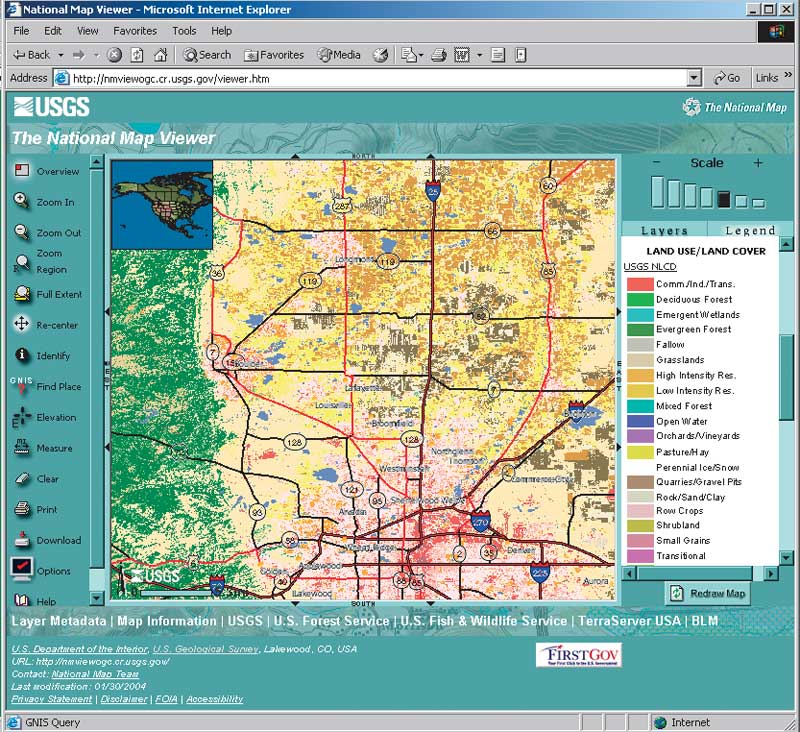
| The National Map Viewer lets visitors browse data, make maps, and access other data sources. |
This framework for national geographic knowledge was developed by USGS as part of its mission to meet the United States' needs for current, base geographic data and maps. The National Map will be a tremendous resource for the half million users of GIS in the United States and will allow them to leverage existing investments in geospatial data.
The National Map complements the objectives of the National Spatial Data Infrastructure (NSDI) and the Geospatial One-Stop Initiative. NSDI, created by Executive Order 12906 in 1994, promotes the sharing of geospatial data throughout all levels of government as well as in the private sector and academic community. The Geospatial One-Stop (geodata.gov) is a Web-based portal for sharing maps, data, and geospatial services.
Replacing Aging Paper Maps
Approximately $1.6 billion and 33 million person-hours were devoted over the last quarter century to the creation of the existing USGS topographic 7.5-minute quadrangle maps. These maps, and the digital data associated with them, have captured the nation's natural and human features and represent the most complete inventory of geographic infrastructure. However, the 55,000 maps that make up the series range in age from one to 57 years with an average age of 23 years. Some maps have never been updated, and the currency dates for adjacent maps may be decades apart. Although these maps represent a great achievement, they are becoming woefully outdated.
Geographic information provides the foundation for the nation's economy and government activities. It is instrumental in economic development, land and natural resource management, and health and safety services. In addition, private industry, nongovernmental organizations, and individual citizens rely on geographic data.
The events of September 11, 2001, underscored the critical role of geographic data and geographic information in responding to an emergency. A draft Memorandum of Understanding between the Department of the Interior and the newly established Department of Homeland Security acknowledged the importance of geospatial data by characterizing the framework data of The National Map as "the domestic common operating picture for homeland security." Current, accessible spatial data is needed to secure U.S. borders, defend against bioterrorism, and support first responders.
The National Map will transform the familiar quadrangle topographic paper series into a seamless, integrated, and online database and, in the process, vertically integrate geographic information for all levels of government. It will provide comprehensive coverage of the nation's critical infrastructure.
A Truly National Map
Since its creation in 1879, USGS has been the source for civil federal mapping and has ensured that consistent base geographic information was available to government, industry, and the public. With The National Map, USGS is developing a more effective strategy for fulfilling that mandate.
Although The National Map is part of the USGS modernization program, the agency envisions this project as a truly national map that will be created through a national effort—not just the activities of the federal government. Alliances are being forged between USGS and state and local governments, other federal agencies, nongovernmental organizations, universities, and the private sector. USGS is enlisting the help of partners in areas such as data and database development and maintenance, data dissemination, and the exchange of geospatial and remotely sensed data. Partners will also be involved in outreach, education, research activities, application development, Web mapping services and applications, and standards development. These partnerships should result in the development of high-quality, current, and consistent national datasets.
These national datasets will include high-resolution digital orthorectified imagery from aerial photographs and satellite imagery; high-resolution surface elevation data including bathymetry; and vector feature data for hydrography, transportation, structures, government unit boundaries, public land boundaries, geographic names for physical and cultural features, and classified land cover data.
Implementation Plan
The National Map Viewer, the initial Web application developed for The National Map, lets visitors browse available data, view and make maps, and link to more detailed and complete data sources. All content for The National Map will be documented with Federal Geographic Data Committee-compliant metadata.
Through The National Map Viewer, users can access and interact with USGS national datasets 24 hours a day. Currently, many of these layers are populated and data is continuously added. For selected major urban areas, high-resolution orthoimagery is available. All USGS digital orthophoto quadrangles (DOQs) and digital raster graphics (DRGs) can be viewed along with the undated land cover dataset and national forest boundaries. Links to commercial datasets provide additional features and enhanced attribute data.
Although Stage 1 of The National Map implementation has many goals, the emphasis will be on developing key partnerships, formally defining processes for documenting design and implementation procedures, managing the requirements of The National Map, analyzing user requirements, and developing tools and in-house expertise for the project. The focus of Stage 2 will shift from data acquisition to research, science, and application development and maintenance of data currency through updates provided by state and local governments and private industry.
Promising Outlook
The National Map will supply an order of magnitude improvement on data currency from years or decades to days and months. Changes affecting The National Map will be captured and integrated with existing data in a process of continuous update, rather than through a cycle of inspection and revision that spans years.
Along with improved currency will come lower costs, reduced redundant geographic data, and much greater access to this data by all levels of government and the public. An internal report by the Department of the Interior in 1995, The State of GIS in the Government, estimated that it was 80 percent less costly to produce and maintain digital maps as compared to paper maps.
Digital spatial data is essential to nearly all sectors of the national economy. The private sector needs current and accurate digital data. Trucking companies use transportation data for fleet vehicle routing. Retailers use the same data for scheduling home deliveries. Telecommunication companies use digital elevation data for cellular telephone tower siting. Elevation data is also used for airline and general aviation flight path planning. These are examples of the many ways this data is used to benefit the economy.
Because of its integration capacity, GIS and geospatial data has been woven into the fabric of thousands of government agencies across all levels of government. This digital data is used for tasks such as transportation planning, public health epidemiology, water and wastewater management, and social services and represents an investment of millions of dollars.
By providing a foundation for a modern geographic data infrastructure, The National Map will let public and private organizations leverage existing investments in geospatial data and improve the access, integration, and application of geospatial data to a myriad of activities that benefit the country as a whole.
|