ArcUser Online
Unfortunately, recharge and discharge rates and patterns are difficult to characterize and cannot be estimated using a single method for all practical applications. This adds uncertainty to the management of water resources. Conventional recharge and discharge studies usually require field characterizations that are labor intensive and require months to complete. A Critical Research PriorityWhen Bertrand Russell (1872–1936) wrote, "What men want is not knowledge but certainty," he must have been thinking of public water supplies. People expect water to flow when they turn on their taps. Effective management of water resources requires quantifying the interactions among the complex and uncertain processes in the hydrologic cycle. Groundwater recharge and discharge depend on the hydrological relationships among groundwater, climate, and surface water. In general, it is not possible to directly measure fluxes into and out of the groundwater system over large spatial scales. Hence, indirect methods must be used. A practical method capable of identifying recharge and discharge zonations using readily available data in a short working time frame will help water resource managers and investigators plan more efficient strategies for additional modeling and data collection activities required by conventional recharge and discharge estimation methods. The delineation of recharge and discharge zonation in conventional methods is to some degree arbitrary and subjective. Therefore, an approach based on cross analyzing results from various methods and using existing ancillary data should lead to more objective predictions than current approaches based on only a single method.
ArcGIS proves an ideal platform for the cross-analyzing approach to estimate initial recharge and discharge maps. Fast initial recharge and discharge estimation and mapping help decision makers and modelers design more accurate and cost-effective models before initiating labor-intensive field measurements. PRO-GRADEA new GIS-based methodology that uses an ArcMap plug-in has been developed that helps hydrogeologists estimate recharge and discharge more efficiently than conventional methods. By leveraging the strengths of ArcGIS for cross analysis, scientists at the University of Illinois have developed a new GIS based methodology along with an ArcMap plug-in package, PRO-GRADE or Pattern Recognition Organizer and Groundwater Recharge and Discharge Estimator, to help hydrogeologists estimate recharge and discharge in a more efficient way than conventional methods. PRO-GRADE uses several image processing algorithms to estimate and visualize shallow recharge and discharge patterns with ArcGIS 9.2. It requires a preparation time measured in hours rather than months and uses readily available data for water table and bedrock elevations and hydraulic conductivities. It can provide a fast initial estimate prior to planning labor-intensive and time-consuming field recharge and discharge measurements. PRO-GRADE is a free software package for research and educational purposes. Its development was sponsored by the U.S. Geological Survey and National Institutes for Water Resources. The plug-in was developed to assist ongoing assessments of the water resources in Illinois and Wisconsin and is also being used to assist several groundwater resource studies in Nevada, California, and New York. The package consists of two separate programs—the Pattern Recognition Organizer for GIS (PRO-GIS) and the Groundwater Recharge and Discharge Estimator for GIS (GRADE-GIS).
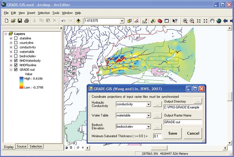
PRO-GIS is a general utility that organizes several image processing algorithms into one user interface to offer the flexibility to extract spatial patterns according to the user's needs. It provides generic pattern recognition functions that support virtually any spatial decision support system (SDSS) used to assist in management applications such as water resources, land use, and agricultural development. GRADE-GIS is a groundwater recharge and discharge estimation interface that requires only the raster files for hydraulic conductivity and water table and bedrock elevation data for two-dimensional steady-state unconfined aquifer systems. PRO-GRADE adheres to the default raster file developed by Esri as the standard for storing spatial information. Several ArcObjects components were utilized for spatial data access and mapping. The installation process follows the standard procedures for Windows programs and customized ArcMap command tools. The package was coded in Microsoft Visual Basic. PRO-GRADE requires the following software be installed:
Methodology for PRO-GISPRO-GIS in the PRO-GRADE package demonstrates the benefit of organizing various image processing algorithms into one graphic user interface. This organization provides an efficient and systematic approach for scientists to analyze images by using image process methods and comparing the images with relevant but not quantifiable ancillary information.
For example, recharge and discharge are known to relate to surface water features, soil types, land use, and topography. However, there is no deterministic function to delineate these relationships. The current version of PRO-GIS implements three image processing methods using different approaches—the 2D Moving Average, normalization, and TVL1 Low Pass Filter. The 2D Moving Average directly inherits several functions from Generalization ArcObjects in the ArcGIS Spatial Analyst extension. These ArcObjects include FocalStatistics and BlockStatistics including their statistical options of Majority, Maximum, Median, Minimum, Minority, Range, Standard Deviation, and Variety. The width and height of the moving window for averaging computations can be specified in the corresponding text boxes. A larger moving window usually generates a smoother image but requires more computation time. Normalization implements traditional algorithms based on existing FORTRAN code. This option transforms the original input data to a normal distribution, which is helpful in reducing the skewness. TVL1 Low Pass Filter was adapted by modifying a new algorithm, Total Variation Regularized L1 Function Approximation, which has applications such as medical magnetic resonance imaging (MRI) scan analysis. It minimizes the total variation of the image subject to preserve pattern edge with simplified computational parameter selection, minimal signal distortion, and the flexibility to extract variable degrees of spatial details. There is an option for Including Normalization and Back Transformation in the TVL1 option to transform the original data into a normal score before the TVL1 process and then back transform to the original range. This is an option to preprocess a dataset with a small number of extreme values and keep the resultant data range in the same scale as the original data range. In the future, developers will be able to use similar approaches demonstrated in these three methods to expand the capabilities of PRO-GIS and tailor the application to the needs of each individual project. GRADE-GIS MethodologyPRO-GRADE includes (but is not limited to) a default recharge and discharge estimation tool (GRADE-GIS) that uses a finite difference mass balance approach for two-dimensional steady state conditions. GRADE-GIS only requires hydraulic conductivity, water table, and bedrock elevation input raster files, which are synchronized ahead of time in coordinate projections, grid size, and grid number. It generates cell-by-cell recharge and discharge rates in a raster file, which is automatically synchronized with input raster files.
The output raster file of recharge and discharge rates from GRADE-GIS is format-ready for PRO-GIS, which can perform further pattern recognition to identify the recharge and discharge zones. The coupling processes of using GRADE-GIS and PRO-GIS can provide a fast initial estimate prior to planning labor-intensive and time-consuming field recharge and discharge measurements. With the ArcGIS platform, the resultant recharge and discharge maps from PRO-GRADE can be cross analyzed with ancillary field information, such as land coverage, soil type maps, surface water distribution, and topographic slope, that has a direct but unquantifiable relationship with recharge and discharge. Real ApplicationsThis new approach has been tested using the dataset from the Buena Vista Groundwater Basin, a thoroughly understood system in the Central Sand Plains of Wisconsin. The coupling processes of using GRADE-GIS and PRO-GIS enable users to generate as many alternative recharge and discharge maps as necessary within minutes or hours. Users can compare alternative maps with external information in GIS and prioritize alternatives. Prioritized recharge and discharge maps can be used as an initial guideline for field study planning and decision making or can be used as initial conditions for numerical simulation and parameter estimation for more detailed analysis. PRO-GRADE is currently being used for several studies including an ongoing assessment of the water resources of the 11 counties in northeastern Illinois.
The study area includes Chicago, which anticipates population growth of two million residents between 2000 and 2030, an increase of 25 percent. This projected growth may be limited by the availability of water from the shallow aquifers in the region. An ongoing assessment of the water resources of northeastern Illinois suggests that a detailed recharge and discharge study, including uncertainty assessment, is necessary due to the complexity of these shallow aquifers and the rapid urbanization adjacent to the Chicago metropolitan area. This approach will greatly improve the understanding of spatial shallow recharge and discharge in this region and assist in mapping estimated recharge and discharge for multiple scales of aquifer modeling and water resource management. Software AvailabilityPRO-GRADE is free and can be downloaded from http://www.sws.uiuc.edu/gws/sware/prograde/. The download package includes the installation program, user's guide, and sample files. One of the authors, Dr. Yu-Feng Lin (Forrest) of the Illinois State Water Survey and University of Illinois, Urbana-Champaign, will provide the source code at no cost. He may be contacted at yflin@uiuc.edu or 2204 Griffith Drive, Champaign, IL 61820-7495. AcknowledgmentsThis project is sponsored by the U.S. Geological Survey and National Institutes for Water Resources, National Competitive Grants 104G. Data for the case study described in this article was provided by the U.S. Geological Survey, Wisconsin Water Science Center, Middleton, Wisconsin; the Wisconsin Geological and Natural History Survey; and the Central Wisconsin Groundwater Center of the University of Wisconsin Extension. The authors thank Dr. Randall J. Hunt from the U.S. Geological Survey Wisconsin District in Middleton, Wisconsin; Dr. Ming Ye from Florida State University; and the other beta testers for helping improve this software package. About the AuthorsYu-Feng Lin (Forrest) is an associate professional scientist at the Illinois State Water Survey and the University of Illinois, Urbana-Champaign. He was a National Center for Supercomputing Applications Faculty Fellow in 2006. His research interests have involved numerical modeling, groundwater and surface water interaction, nano-sensor development, and water resources investigations in Illinois. Jihua Wang is a doctoral candidate in the Department of Civil and Environmental Engineering at the University of Illinois, Urbana-Champaign. Her major interests are groundwater modeling, water resources planning and management, and eco-hydrology. Albert J. Valocchi is a professor and associate head in the Department of Civil and Environmental Engineering at the University of Illinois, Urbana-Champaign. His research interests include modeling the fate and transport of reactive contaminants in the subsurface environment, numerical methods, aquifer remediation, and mathematical modeling applications in the environmental and hydrological sciences. ReferencesBradbury, K. R., W. Dripps, C. Hankley, M. P. Anderson, and K. W. Potter, 2000, Refinement of Two Methods for Estimation of Groundwater Recharge Rates, Final project report to the Wisconsin Department of Natural Resources, 84 pp. Cherkauer, D. S., 2004, "Quantifying Ground Water Recharge at Multiple Scales Using PRMS and GIS," Ground Water, vol. 42, no. 1, pp. 97–110. Climate Research Committee (CRC), 2003, Understanding Climate Change Feedbacks, the Board on Atmospheric Sciences and Climate, the Division on Earth Life Studies, National Research Council of the National Academies, the National Academies Press, Washington, D.C. Committee on Hydrologic Science (COHS), 2004, Groundwater Fluxes Across Interfaces, the Board on Water Science and Technology, the Division on Earth Life Studies, National Research Council of the National Academies, the National Academies Press, Washington, D.C. Lin, Y-F., and M. P. Anderson, 2003, "A Digital Procedure for Ground Water Recharge and Discharge Pattern Recognition and Rate Estimation," Ground Water, vol. 41, no. 3, pp. 306–315. Meyer, S. C., D. D. Walker, S. M. McConkey, W. S. Dey, B. Brandon, C. C. Abert, and E. Mehnert, 2002, Water-Resources Investigations for Kane County, Illinois, Proposal to Kane County Development Department, Geneva, Illinois, Illinois State Water Survey and Illinois State Geological Survey, Champaign, Illinois, 55 pp. Northeastern Illinois Planning Commission (NIPC), 2006, 2030 Forecasts of Population, Households and Employment by County and Municipality, http://www.chicagoareaplanning.org/data/forecast/ 2030_revised/ENDORSED_2030_forecasts_9-27-06.pdf. Scanlon, B. R., R. W. Healy, and P. G. Cook, 2002, "Choosing Appropriate Techniques for Quantifying Groundwater Recharge," Hydrogeology Journal, vol. 10, pp. 18–39, DOI: 10.1007/s10040-001-0176-2. Stoertz, M. W., and K. R. Bradbury 1989, "Mapping Recharge Areas Using a Groundwater Flow Model – A Case Study," Ground Water, vol. 27, no. 2, pp. 220–228. |