CASI Data Provides Better Picture of Coral Reef Threats
By Michael Plakos, GEOMAR Research, Inc.
Written for the Khaled bin Sultan Living Oceans Foundation
Data from a programmable imaging spectrograph, captured as part of a mapping program sponsored by an ocean conservation organization, is helping researchers better understand threats to the health of 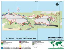 coral reefs in the U.S. Virgin Islands (USVI) and elsewhere. coral reefs in the U.S. Virgin Islands (USVI) and elsewhere.
The Khaled bin Sultan Living Oceans Foundation (LOF) sponsored the program in 2001. LOF is a 501(c)(3) nonprofit organization dedicated to the conservation and restoration of living oceans. The effort, carried out by Dr. Peter Mumby of the University of Newcastle upon Tyne, United Kingdom; LOF; the U.S. National Park Service; and Hyperspectral Data International (HDI) of Halifax, Nova Scotia, mapped more than 41,000 hectares (101,313 acres) of the waters surrounding St. John and St. Thomas with a Compact Airborne Spectrographic Imager (CASI) mounted in an amphibious Cessna 208 Caravan aircraft. CASI is a product of ITRES Research Limited.
Although coral reef ecosystems occupy less than one quarter of 1 percent of the marine environment, they provide refuge for a quarter of the world's marine species. Among the most biologically diverse, oldest, and species-rich ecosystems on earth, coral reefs are often referred to as the rainforests of the marine world.
Coral reefs play an important role in the coastal environment and provide many benefits to mankind. The diverse and abundant species living in coral reefs produce chemicals used in medicines and medical research. Reefs also form natural barriers that protect nearby shorelines from the eroding forces of the sea. Currently one of the endangered ecosystems on the planet, coral reefs are most threatened by land-based pollution and overfishing. At the present rate of destruction, 70 percent of the world's coral reefs will be killed within our lifetime.
To help reduce, and possibly reverse, this astonishing rate of destruction, LOF, Mumby and his team at the University of Newcastle, and the U.S. National Park Service collected multispectral imagery using a CASI spectrometer over waters surrounding St. John and St. Thomas. This data will help researchers better understand local ecological and disturbance factors. These insights could be expanded regionally and globally. This data has been distributed to the recipients initially targeted. LOF is now trying to reach a much wider audience by using ArcGIS to integrate the data and serve it to remote users using ArcIMS.
CASI Imagery
Coral reefs are dynamic and are affected by environmental changes, both natural and man-made. Understanding changes in an extremely localized environment may be possible by using conventional methods such as underwater video and direct observation. Changes that have occurred on a larger scale and have had a greater impact are much more difficult to study. In recent years, technologically advanced instruments and methods for studying coral reefs have been developed. An increasing number of researchers are turning to remotely sensed imagery from satellites and aircraft equipped with advanced imaging sensors.
CASI imagery, while not as widely known as Lidar, aerial photography, and satellite imagery, has proven extremely useful, especially in recent years. A CASI spectrometer can measure radiation with as many as 288 spectral bands at user programmable intervals from 400 to 1,000 nanometers of the electromagnetic spectrum. Essentially, CASI imagery combines the digital multispectral capability of satellite imagery and the high spatial resolution of aerial photography.
Satellite imagery typically offers 15- to 30-meter resolution and cannot be used to distinguish detailed reef structure. As light attenuates through the water column, the ability to distinguish features with increasing depth is severely hampered, a common limitation with aerial photography. However, if proper altitudes are maintained, CASI can achieve resolutions of 0.5 to 1 meter. Because CASI's spectral collection is programmable, it can also be calibrated to better match the environmental setting. Digitally collecting each band individually also allows light attenuation to be modeled, enhancing bottom feature signatures.
Putting Imagery to Work
Of the many products that can be derived from overhead imagery, habitat maps are probably one of the most useful and essential tools to researchers and coastal environmental managers. In its most basic form, a habitat map delineates the boundaries of different bottom types such as coral cover, sea grass, and sand.
Continued on page 2
|
