ArcUser
Summer 2012 Edition
Making Thematic Data Work as a Web Map
By Kenneth Field, Senior Research Cartographer
This article as a PDF.
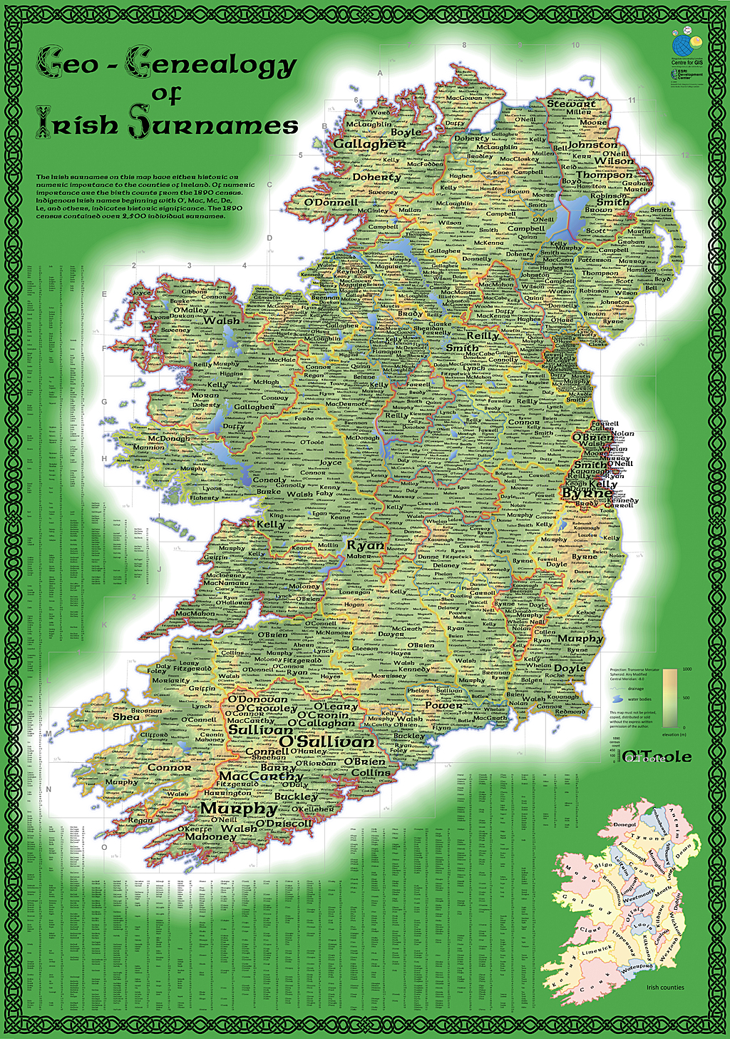
The original print version of the Geo-Genealogy of Irish Surnames map, created for the 2009 Esri User Conference, mapped simple data in an engaging way.
Back in 2009, I created a thematic map for the Esri User Conference (Esri UC) that showed the location of Irish surnames from the 1890 census. It was a simple map, based on an idea by my coworker Linda Beale. The challenge was to create a persuasive map that was eye-catching and invited people to explore it by hunting for a particular name.
The data was remarkably simple: a column of surnames, a column of Irish counties, and a column giving the number of people born in that county in 1890. Although simple, there was a lot of data. Presenting it in a compelling way was challenging. The eventual design was strong yet clean, and it was innovative because it took a standard thematic mapping technique (proportional symbols) and used it in a different way by making the name labels proportional so that they became part of the visual story. A lot of emerald green emphasized the theme. The map had a clearly defined readership, and it generated buzz at the Esri UC, creating a strong emotional response, particularly in people with Irish heritage.
Fast-forward to 2012. I wanted to create a version of the map for ArcGIS Online. I couldn't simply replicate the map in an online environment. Web maps offer new ways of seeing the data as well as alternative requirements for data manipulation, so I treated this as a new project.

The design for the print version of the Geo-Genealogy of Irish Surnames map used name labels as proportional symbols so that they became part of the visual story.
In ArcGIS for Desktop, I had used the Maplex labeling engine and the Disperse Markers tool to create the proportional labels and position them on the previous map. ArcGIS Online doesn't offer the same tools, but by converting the labels to polygons using the Feature Outline Masks tool, exporting to shapefile format, and adding them to the ArcGIS Online map, I was able to replicate the proportional symbols. (See "Adding labels to ArcGIS Online web maps: Part 1" and "Adding labels to ArcGIS Online web maps: Part 2" on the Esri Mapping Center blog to learn about this process.)
I applied 100 percent transparency to the basemap and used my own simplified county boundaries. It was important to simplify the line work so the map would load, pan, and zoom effectively. The vignette effects and a detailed hillshade with layer tints used for the print version would slow the refresh rate significantly for the web version. Instead, a simple four-color map showing the counties is a more functional, yet still visually appealing, approach that supports the performance of the map in this medium.
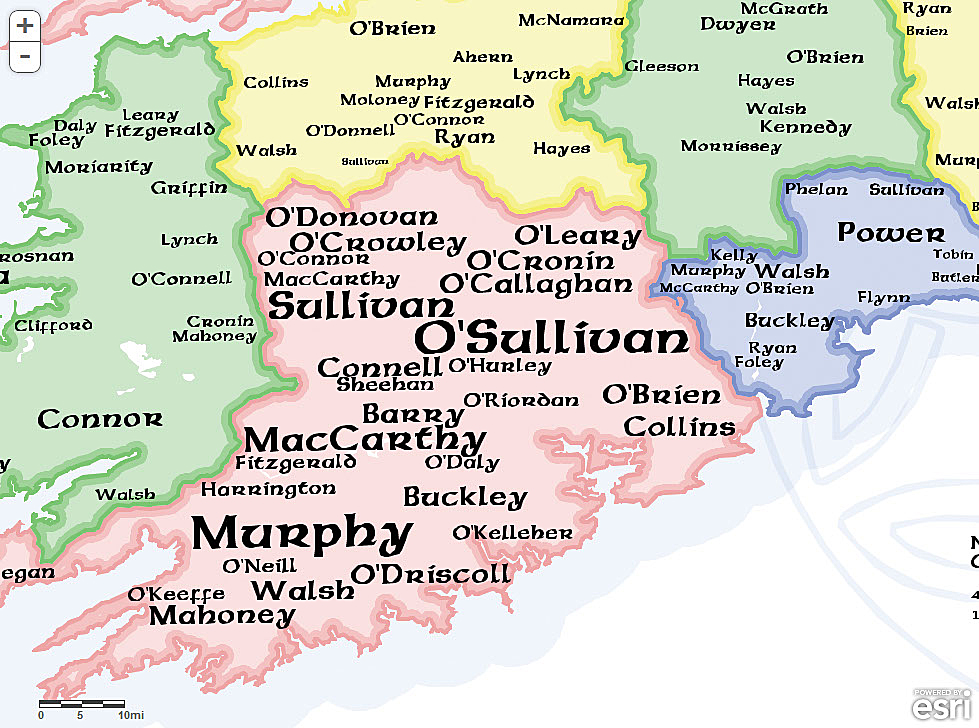
The version of the Geo-Genealogy of Irish Surnames created for ArcGIS Online required new ways of seeing the data as well as alternative requirements for data manipulation.
The multiscale nature of the web map required some careful thought because the previous print version was designed for a single scale. At a small scale, the labels on the web simply aren't visible. Because users can zoom to different scales, scale visibility ranges can be used to ensure certain labels appeared at certain scales. At smaller scales, only the larger labels are visible, supporting the idea that these surnames are the most common. As the user zooms in, smaller labels are added to the map. This structures the information and also takes advantage of the multiscale nature of web maps. (See "Using scale visibility ranges for symbology in ArcGIS Online web maps" on the Esri Mapping Center blog). I added some graphics and used simple pop-ups so users could mine the data, and the map was finished. View the web map application by searching for Geo-genealogy of Irish Surnames on ArcGIS Online.
The print and web map I created share a common ancestry but were designed very differently. However, this isn't the end of the story of this map. For St. Patrick's Day 2012, Allen Carroll and his Story Map team took the web map version of this map a little further.
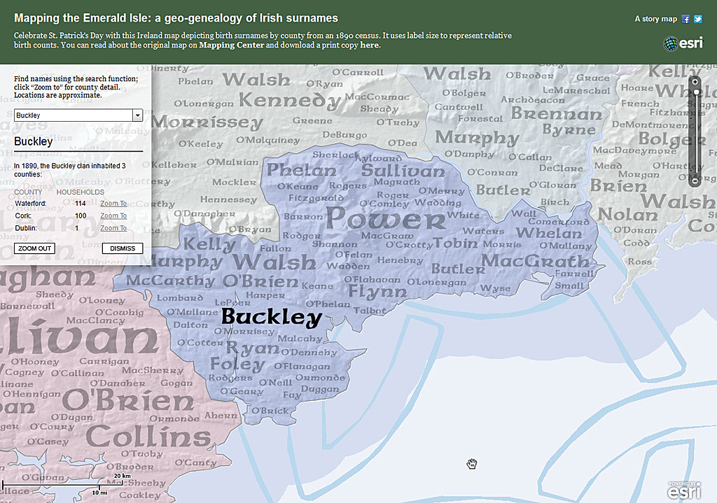
The Mapping the Emerald Isle web map application created additional ways of engaging with the information interactively while retaining the simplicity of the original design.
Using the JavaScript API, the team modified the way the data was configured and presented as a web map application. The zoom levels were restricted to four scales that were purposeful for the map. Creating cached tiles of the basemap and the labels improved performance considerably so a subtle hillshade could be added back, giving the map more visual interest. Finally, a search tool was added that allows users to type in a surname (it uses autocomplete to give alternatives). It returns surname counts and zooms the extent directly to that part of the map. To make search results more legible on the map, other labels are temporarily grayed.
The search facility provides a useful way to explore the map that goes beyond what was possible in the print version. The web map application creates additional ways of engaging with the information while retaining the simplicity of the original design. View the Mapping Emerald Isle web map in the Storytelling with Maps gallery.
The Irish Surnames map went through three iterations: a print map, a web map, and a web map application. Each used a relatively simple thematic dataset but demonstrated how it was used to turn an idea into a great map suited, in each case, to its purpose and the medium for which it was created.