ArcUser
Fall 2011 Edition
Making Sure Wastewater Isn't Wasted
GIS aids in managing the application of biosolids
By Kara Klinger, GIS Analyst, Hampton Roads Sanitation District
This article as a PDF.
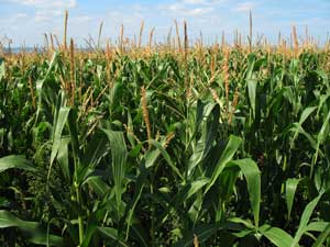
A typical corn field found in the Hampton Roads area of Virginia
Ever wonder what happens to all the wastewater sent to treatment plants?
Farmers in Chesapeake and Virginia Beach, Virginia, use a product created from wastewater called biosolids. By applying biosolids to farmland, a natural resource that preserves healthy soils and benefits crops is recycled back into the environment rather than wastefully disposed of in landfills.
GIS helps ensure that all biosolids created and applied to farmland by the Hampton Roads Sanitation District (HRSD) of Virginia Beach comply with federal, state, and local regulations and has simplified the process of keeping field maps and records current.
Nutri-Green Biosolids, a brand of biosolids sold by HRSD, is produced from wastewater cleaned by separating the solids from the liquid portions through the natural biological, chemical, and physical treatment of wastewater. The separated solids contain nutrient-rich organic material consisting of sand, plant nutrients, microorganisms, and trace amounts of metals. The biosolids product is characterized by a moist to dry soil material with a naturally mild organic odor that dissipates once applied to farmland. The nutrients from biosolids are in an organic form and act as a slow-release fertilizer and soil conditioner. They improve the soil properties, counteracting the effects of wind and water erosion, increasing plant productivity, and reducing dependence on chemical fertilizers.
Biosolids may be applied once every three years. The US Environmental Protection Agency and the Virginia Department of Environmental Quality have established regulations that require monitoring the quality and contents of biosolids and employing best management practices for controlling the specific application sites.
HRSD has been recycling Nutri-Green Biosolids to agricultural land application sites since 1981. Currently more than 1,500 acres of farmland in Chesapeake and Virginia Beach use biosolids each year on fields growing corn, soybeans, pasture, and hay crops.
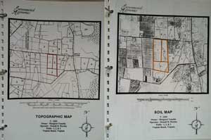
HRSD's Treatment Department maintains biosolid land application sites. With help from a hired consultant, HRSD developed Field Site books that contain correspondence and maps pertaining to the physical and soil properties of the crop fields. The books are part of HRSD's Atlantic Plant Virginia Pollutant Discharge Elimination System (VPDES) permit and contain required regulatory information. Currently, more than 180 Field Site books have been created. However, over time, biosolids site information can change: property boundaries move, new farmers or landowners are added, and new buffer guidelines must be enforced. These and other changes require remapping and updating Field Site books.
Migrating to ArcGIS
During 2008, the Treatment Department consulted with Planning and Analysis' GIS Group to determine if this project could be migrated to ArcGIS so maps and Field Site books could be more easily kept up to date. The process adopted can be summarized in seven steps:
- Create Permitted Biosolid points.
- Create Permitted Biosolid fields.
- Add soil data from the National Resources Conservation Service, United States Department of Agriculture.
- Perform calculations on acreage and percentage of soil type for each biosolid field.
- Collect buffered features based on Virginia Department of Environmental Quality (DEQ) requirements with a Trimble GeoXT unit.
- Modify existing biosolid layers to accommodate buffered results.
- Maintain the Biosolid Land Application Project database in ArcGIS.
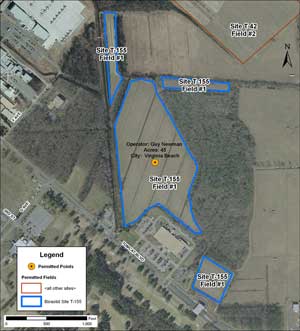
This biosolid site is represented by the same field number in various locations. Site T-155 shares the same field number but is represented by four polygon shapes because barrier structures, such as wooded areas and commercial properties, are present.
The first step was identifying biosolid fields by physical location. Fortunately, a hired consultant who was familiar with the project had already collected the x,y coordinates for most of the biosolid fields in Virginia Beach and Chesapeake. The coordinates, which provided a general point location for these fields, were stored in Microsoft Excel. Unfortunately, the x,y coordinates were in different map units. Safe Software's FME software was used to transform the map units for all points to decimal degrees.
A personal geodatabase called pGDB_Permitted_Sites.mdb was created in ArcGIS for storing the feature classes used in the Biosolid Land Application Project. The x,y coordinates stored in Excel were used to create a point feature class called Permitted Points. A table containing fields for site names and paths to contract locations was created and joined to the Permitted_Points attribute table so each biosolid site could be hyperlinked to its landowner agreement contract for on-the-fly access by users.
The next step was correlating the Permitted_Points table with biosolid field outlines. The Permitted_Fields layer was created based on the parcel layers for Virginia Beach and Chesapeake. The exact parcel outline was copied or modified based on the Field Site book and project orthoimagery. Orthoimagery for the project was captured in 2007 at six-inch and one-foot horizontal resolution.
Biosolid site locations contain many fields associated with one site. Some sites share the same crop field number but must be represented as multiple polygon shapes because barrier structures—such as roads, bodies of water, wooded areas, and residential and commercial properties—break up biosolid farm sites. Other sites are associated with various, and at times recurring, field numbers in multiple locations, which could be challenging, especially for new users.
| Adjacent Features | Surface Application | Incorporation | Winter Application* |
|---|---|---|---|
| Occupied dwellings | 200 | 200 | 200 |
| Property lines, water supply wells, or springs | 100 | 100 | 100 |
| Perennial streams, other surface waters except intermittent streams | 50 | 35 | 100 |
| Intermittent streams/Drainage ditches | 25 | 25 | 50 |
| All improved roadways | 10 | 5 | 10 |
| Agricultural drainage ditches slopes < 2 percent | 10 | 5 | 10 |
* Application on slopes > 7 percent between November 16 and March 15
Obtaining and Creating Soil Attribute Data
Additional attributes, such as its identifying site name, field number, operator, landowner, city, location, and acreage, were added to the Permitted_Points and Permitted_Fields layers. Attribute data was obtained from the Field Site books or by performing queries in ArcGIS on the data. The application of Nutri-Green Biosolids is based on existing soil conditions, so obtaining the soil data for Virginia Beach and Chesapeake was important. Rhonda Bowen, who is in charge of the Nutri-Green Biosolids Recycling Land Application Program, obtained current soil data from the United States Department of Agriculture Natural Resources Conservation Service Soil Data Mart website (datagateway.nrcs.usda.gov). The soil data was imported into the personal geodatabase so the PermittedSites_Soils layer could be manipulated.
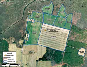
This biosolid site is represented by uniquely identified field numbers in various locations. Site T-439 is represented by nine polygons. Wooded areas act as a barricade structure that separates field #9 from the rest of the fields.
Because the soil type key field is not universal across the United States, matching the soil type key field with its soil description for Virginia Beach and Chesapeake was tricky. After downloading and adding the soil data to an ArcMap document, it was clipped against the Permitted_Fields layer to create individual soil areas for each field in each site. Dividing the size of individual soil areas by the entire site size produced the percentage of each soil type in each field. The percentage of each soil type was correlated with its field number (if it had the same field number); otherwise, the soil percentage value was broken down for each field number. This value was recorded in the Soil_Percent field of the attribute table for the Permitted_Fields layer.
Obtaining DEQ Buffer Restriction Data
Because the Virginia DEQ does not allow the application of biosolids to agricultural land within specified distances of occupied dwellings, property lines, water supply wells or springs, perennial and intermittent streams, surface waters, drainage ditches, and other features, buffers had to be created around these features. Unfortunately, none of the features that required buffering had been captured, nor could they easily be seen on orthoimagery. This necessitated on-site field visits to capture the coordinates for these features. In the spring, the Treatment Department purchased a Trimble GeoXT GPS unit to collect the features to be buffered before the Nutri-Green biosolids were applied to the farmland sites.
Two feature classes, BufferFeatures and BufferApplication, were created in the personal geodatabase to hold the data collected by a consultant hired for the Biosolid Land Application Project. These feature classes, enhanced with domains for easier, valid data collection, were converted to ArcPad shapefiles. The BufferFeatures layer is a line feature class that captures the edge of the buffered feature to allow new buffered distances to be applied to the same feature to accommodate any change in buffer requirements. The BufferApplication layer is a polygon feature class created based on the BufferFeatures layer that contains DEQ buffer application distance requirements for different feature types. These buffers are used to create a more accurate representation for each BufferApplication shape.
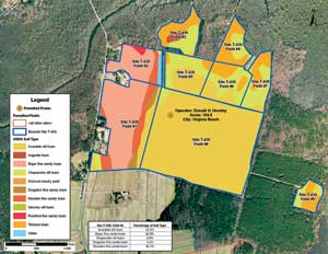
The soil types within each field are shown for Site T-439, a biosolid site. The soil percentage was broken down for each individual field, as shown by field #1.
Challenges Involved with the Project
Buffer creation and the need to collect the locations of buffered features on-site were challenging facets of this project. Another challenging aspect was introducing both internal and external personnel to ArcGIS and Microsoft Access. However, with documentation describing how to create ArcGIS layers and maintain databases and through using the ArcGIS help, this challenge was resolved in a reasonable time frame.
The Future
The migration of the Biosolid Land Application Project to ArcGIS has been ongoing for more than three years now. Though the project is not yet completed, it has successfully met its goals. For instance, the ability to generate soil percentages for each field site and have all DEQ buffered features shown for analysis purposes is groundbreaking. The project's progress from just having Field Site books to using x,y coordinates for the Permitted_Site locations and having a database created for biosolid sites is pretty spectacular.
In addition, HRSD can share the shapefiles for all permitted farm fields with the cities of Virginia Beach and Chesapeake, so they can also track the biosolid land application program. Bowen is working on the creation of even more substantial data for the biosolid layers. Eventually, the biosolid sites and data will be maintained solely in ArcGIS, and the Map Book series will be used to easily produce maps.
For more information, contact
HRSD
Rhonda L. Bowen
Recycling Manager
1440 Air Rail Avenue
Virginia Beach, Virginia 23455
T 757 460 4270
E WriteUS@HRSD.com
About the Author
Kara Klinger, a GIS analyst with the Hampton Roads Sanitation District, worked with GIS applications for utilities for more than 10 years and has been involved with building GIS systems from the ground up. She holds a bachelor of science degree in geology with an emphasis in GIS from Old Dominion University, Norfolk, Virginia.
