ArcUser
Fall 2011 Edition
Map Production Increased by 50%
With the same staff, using new system
By Michal Traurig, Land Survey Office of the Czech Republic
This article as a PDF.
Digital topographic maps for the whole area of the Czech Republic have been published since 2001. Ten years later, the production system has been changed to a new one based on ArcGIS technology. This new system inaugurated a continuous updating process for maps.
Land Survey Office (LSO) administers the National Map Series of the Czech Republic. In recent years, LSO has developed the Information System of the National Map Series (IS NMS) in conjunction with the company T-MAPY spol s r.o. Basic and thematic maps at scales from 1:10,000 to 1:100,000 are processed in this system. The whole cartographic system is based on Esri products with the support of CPS eXpress, application software produced by Esri partner T-Kartor Sweden AB.
The National Map Series of the Czech Republic, created beginning in the 1970s, was the basis for the Fundamental Base of Geographic Data of the Czech Republic (ZABAGED) digital database. The previous map production methodology was developed in a MicroStation environment with MGE extensions. The production line for Basic Maps of the Czech Republic—very modern at that time—became out-of-date over the last 10 years, prompting the move to a new map production process based on Esri technologies.
From the beginning, many demands were made of the new system. The most significant requirements were
- Keeping linkage to the source databases—ZABAGED and the geographic names database (Geonames)
- Storing the data in a seamless database (This is one of the main differences between the old and new technologies. In the old system, data was stored in separate files. Each map sheet was a project containing many files.)
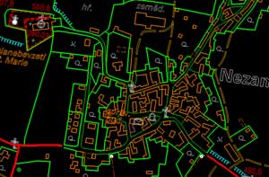
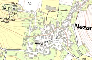
- Creating visualization with cartographic representations for basic maps at scales of 1:10,000 and 1:25,000 without changing the geometry of the data
- Detecting changes in the databases during the update process (In contrast, in previous systems, changes meant that the whole map sheet had to be remade.)
- Increasing map production by approximately 50 percent using the same number of employees
- Maintaining very high standards for printed outputs
Software Used
ArcGIS is used on the server and the desktop. ArcGIS Server Basic for Enterprise stores and manages spatial data in Oracle 11g. ArcGIS Desktop (ArcView, ArcEditor, and ArcInfo) is used for cartographic production. IS NMS also uses Maplex for better label placement, the ArcGIS Data Interoperability extension to import and export files in additional formats, and the ArcGIS 3D Analyst extension for creating 3D models of altimetry.
CPS eXpress is an extension designed for ArcGIS Desktop. With its help, a cartographer can create a whole map sheet, frame, and outer frame. Workflow Manager (WfM), a web application designed for the general management of IS NMS, is also used in the process.
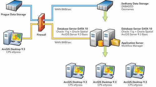
Schema of the Information System of the National Map Series
The Data Structure
The data structure of IS NMS is divided into two parts: DATA 10 and DATA 50. DATA 10 is used for producing and updating ZM 10 and ZM 25 maps (basic maps at scales of 1:10,000 and 1:25,000). DATA 50 is used for producing and updating ZM 50 and ZM 100 maps (basic maps at scales of 1:50,000 and 1:100,000). Thematic alterations at relevant scales can be made in these two map groups. All maps use two main data sources: ZABAGED and Geonames. Thematic databases (internal or from external providers) are used to add thematic content to the maps.
System Architecture
IS NMS was designed using a three-layer architecture that provides optimal communication between data storage, the application layer, and the presentation layer. The system was designed to accommodate client stations located in two cities. Some stations are in LSO headquarters in Prague, but most are located with the servers 50 miles away in the city of Sedl˘cany. Communication between Prague and Sedl˘cany is provided by a wide area network (WAN) with a transmission capacity of 8 MB per second. The data, stored on a high-density disk array, is updated by regular replications.
The server part of the solution consists of two separate database servers, one for DATA 10 and the other for DATA 50. It is also the application server for all IS NMS server applications. The RDBMS is Oracle 11g with an Oracle Spatial extension used for data management. Communication with the database is provided via ArcGIS Server 9.3 Basic. The server portion of the workflow manager for production control is also installed on the application server.
The client portion of the system consists of approximately 50 workstations, of which six are connected via WAN. LSO uses 45 floating ArcGIS Desktop 9.3 licenses. IS NMS uses Maplex to support correct text placement, the ArcGIS Data Interoperability extension for importing and exporting data in various formats, and the ArcGIS 3D Analyst extension for hypsometry work. CPS eXpress is also installed and used for creating map templates.
Map Production in DATA 10
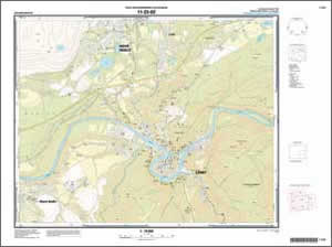
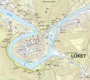
In addition to DATA 10 map sheets produced at scales of 1:10,000 and 1:25,000, IS NMS can also process thematic maps according to a customer's request. Standard maps are output as printed maps using the map sheet division system or as digital raster maps. One of the main reasons for using a seamless database for production line work was the ability to offer map outputs (either standard or according to customer requests), which need not correspond to the uniform sheet line system.
All cartographic edits are made in ArcMap. Cartographers work on a single map sheet in a map series. All map elements located in the envelope of an update procedure are included (i.e., all elements on the map sheet, in the outside buffer of 500 meters, and the inner and outer map frames). Above all, the work on a map sheet consists of solving map symbol conflicts. The cartographer has to correctly place labels and symbols that are close to the map framework. These are positioned in two ways depending on whether they will be displayed on a seamless map or a map using the map sheet divisions.
Map editing is carried out as a type of long transaction. Changes occur in the working version of a database and are posted to the production version of the database only when all work on the map sheet is completed.
ZM 25 map sheets are created after ZM 10 map sheets in an area are finished. Cartographic representations created for ZM 10 can be reused for ZM 25. This significantly reduces the time required for ZM 25 map sheets. Of course, any number of map sheets can be simultaneously processed.
The production manager chooses which areas will be updated, thereby minimizing possible conflicts that might occur between working versions if updates were running simultaneously on the same areas. Any conflicts are solved interactively. Executed changes are posted to the production version of the database only when all conflicts are resolved.
The indisputable benefit of the new technology is its decidedly friendlier user environment. The old technology worked with a wire model, which had its own symbol library. Reading maps on-screen required experience and lots of imagination. Thanks to Esri technology, cartographers now edit in a WYSIWYG environment that is more comfortable. Some features, like masks, are deliberately turned off to make redrawing smoother and faster.
Updating DATA 10
The key to efficient map updating is changing only those elements that need to be changed. The old technology required making a completely new map. The new update process is based on a comparison of original and new features in the source databases. Older time frames can also be used. Changes are grouped together and—when there are a sufficient number of changes—the production manager assigns that map to a cartographer for updating.
There are three types of changes: deletions, insertions, and updates. Features to be deleted were in a previous version but are not in the current version. The system automatically deletes the cartographic representations of these features.
Features to be inserted were not in previous versions but are in the current version. The system automatically assigns a correct cartographic rule to these features. A cartographer can display both deleted and inserted features and check their relationship to surrounding features. Features to be updated have their cartographic representation adjusted by the cartographer.
Map Production Using DATA 50
Maps using the database DATA 50 are produced at scales of 1:50,000 and 1:100,000. As with DATA 10, there are two standard map outputs—a printed map and a digital raster map. Though similiar in principle to DATA 10 map production, the data for DATA 50 maps comes from former MGE projects and is handled differently. New maps are not derived directly from ZABAGED data. This workflow was chosen because of the substantial changes in DATA 50 caused by generalization, especially in layers containing built-up areas. New generalization of these features would take an unacceptable amount of time.
Like DATA 10 maps, all cartographic edits for DATA 50 maps are done in ArcMap as long transactions. Revision is indicated when the data is different from the source databases. Changes, again classified as deletions, insertions, and updates, are generalized and processed using the editing tools. Features directly derived from the source databases are automatically updated if the source data has changed. For more information about IS NMS, contact michal.traurig@cuzk.cz.
About the Author
Michal Traurig, who works in the Land Survey Office as head of the department of cartography and print making, is also the IS NMS project manager.
