ArcUser
Fall 2011 Edition
Small Scripts, Big ROI
ArcGIS resources dramatically speed property reappraisal
By Matthew DeMeritt, Esri Writer
This article as a PDF.
The extension allowed the appraisers to load photos into the ArcPhoto window and drag and drop the photos over their corresponding parcel polygons in ArcGIS, geotagging the image by populating the GPS coordinate fields in the EXIF metadata.
In 2009, Guilford County's tax department could not process large numbers of street-level photos for a property reappraisal project and had no budget to pay for a solution.
In a flagging economy, shrinking government budgets can sometimes force managers to investigate existing available resources, creating solutions with what they already have or what can be obtained for free. In this environment, GIS managers can tap into no-cost online resources such as free extensions and scripts, many designed to solve specific workflow problems. Project supervisors in Guilford County discovered free ArcGIS applications that helped the tax department create a photo geotagging system that dramatically exceeded the North Carolina county's objectives.
Sync Problem
To ensure fair implementation of the new tax system, all Guilford County properties had to be photographically reappraised. Using simple point-and-shoot digital cameras the county already had, tax department staff took photographs of single-family residential structures to assess their current value. It wasn't long before they realized the department's system of processing the photos wouldn't meet the project's deadline. A key step in this process was manually renaming the photos. At a minimum, the system should automatically title each photo with its parcel ID and populate the image file's metadata.
Ideally, these photos could then be dragged and dropped into parcel polygons on the map, providing an augmented visualization by linking the parcel with its photograph.
The tax department went to the Guilford County GIS Department. Both departments agreed the new system should automatically associate each photograph with its parcel record stored in the computer-aided mass appraisal (CAMA) system. Initially, everyone thought that GPS might be the answer.
"The county already had a few GPS units," said Stephen Dew, GIS manager at Guilford County. "We thought we could automate the process by syncing the camera's internal clock with the GPS unit's internal timing." GPS units collect a data point every second and store it in a track file, which can be displayed as a series of points outlining the route taken by the GPS user. This method could give each photo a spatial location that could be mapped and matched to a digital parcel number in the county's GIS. There was only one problem: the cameras' clocks could not be reliably synchronized with the GPS receivers' clocks.
Way to Geotag
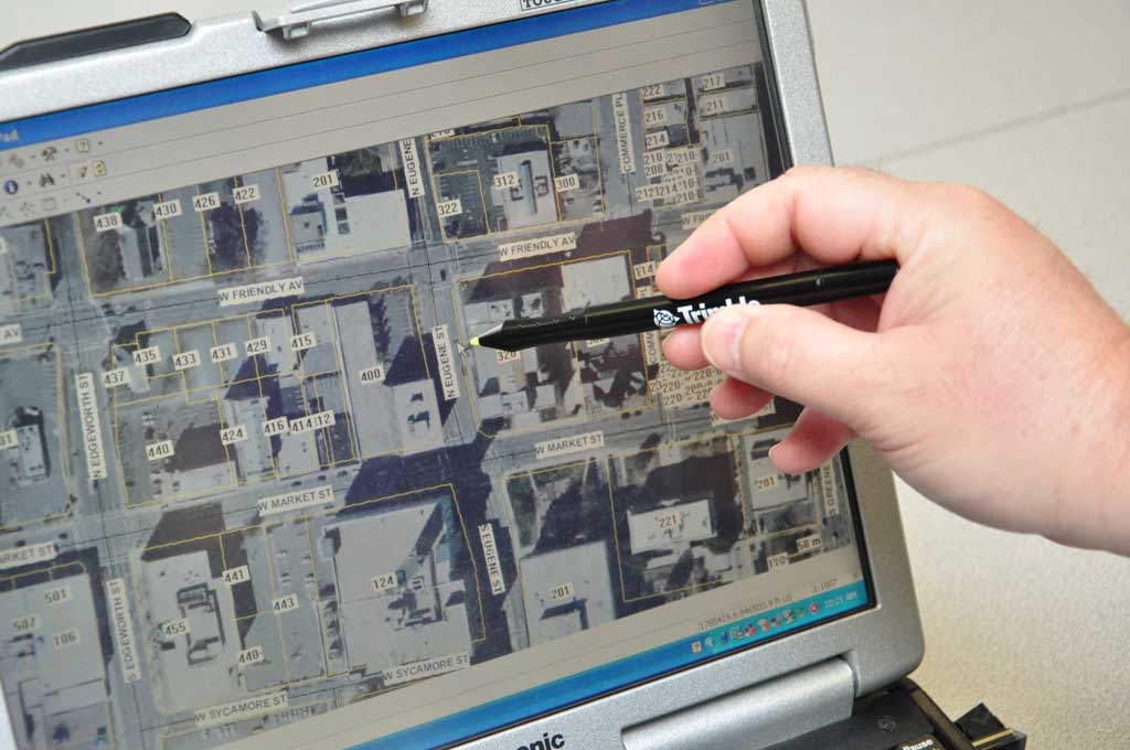
While Dew and his staff pondered another solution, appraisers resorted to manually locating their photos using the free ArcPhoto software extension to ArcGIS found at Esri's ArcGIS Resource Center (resources.arcgis.com). Developed by Esri programmer Thomas Emge, ArcPhoto tools enable the quick import of digital photographs into ArcGIS by working directly off the EXchangeable Image File (EXIF) format metadata encoded into standard digital imagery. In professional-grade cameras or photos taken with ArcPad 7, imagery can hold GPS location information.

The ArcPhoto window allows Guilford GIS staff to view photos within ArcMap. ArcPhoto writes the coordinates in the EXIF header of the JPEG and geotags the image.
The extension allowed the appraisers to load photos into the ArcPhoto window, then drag and drop the photos over their corresponding parcel polygons in ArcGIS, geotagging the image by populating the GPS coordinate fields in the EXIF metadata. The ArcPhoto extension can directly read the EXIF metadata and allows streamlined integration of photos in maps. Using this method to geolocate the parcel images increased productivity from 50 to approximately 200 images per day—a significant improvement but, unfortunately, not on target with the looming deadline.
After automating the process somewhat, Eric Funderburk, GIS analyst and lead researcher for the project, downloaded an ArcScript for ArcPad from the ArcGIS Resource Center. The script created a data entry form in ArcPad that allows the user to enter the number of the first digital image taken. Clicking the Register Picture button writes the complete image file name to the attribute table of the shapefile. After entering the first image, the script sequentially auto numbers the next digital image in the attribute table. This method allowed field crews to quickly take the photo and concurrently assign a point to a digital map before photographing the next house.
Automating with Python
When the appraisers returned from collecting photos, they copied the images to Guilford County's local network. Funderburk simplified this process using Python. "After inserting the camera's SD card into the desktop USB reader, a Python script executes from the user's desktop that reads the SD card in the card reader, including the time and date each digital image was taken," says Funderburk. "This creates a secure directory on the server and copies the images by date to their corresponding directories."
Next, they had to figure out a way to automatically rename each photo (e.g., IMG 001, IMG 002) with its associated parcel ID number (e.g., 334). With the help of Esri technical support analyst James Unger, Dew and Funderburk used another Python script that renamed photos using the point feature class that held the parcel number and the original image file name. The Python script searches the directory where the photos are stored, loops through the records in the point feature class to find a matching image file name, and uses the Parcel_Number field in the feature class to rename the original image with its parcel ID.
Projected Output Exceeded
Reappraisal productivity at Guilford County increased immediately and dramatically. At its peak, crews collected and named more than 750 images per day using the new methods—an increase of 1,500 percent from the initial output. With just two crews in the field, almost 4,000 images were collected and georeferenced in three days. Before adopting this workflow, the tax department had hoped to have a few thousand photographs ready for the new tax system. By the February 2010 cutoff date, it had delivered more than 40,000 images.
Although Guilford County had no money to fund its reappraisal project, using in-house equipment and existing expertise, the tax and GIS departments collaborated and improved the daily output associated with this project. The increase in productivity boosted the morale of the entire appraisal staff and made the project viable. For more information, contact Stephen Dew, GIS manager for Guilford County, at sdew@co.guilford.nc.us. Download ArcPhoto tools.