October - December 2002
October - December 2002 |
||||||||
|
|
||||||||
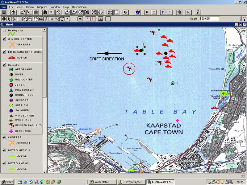
Just short of 90 minutes later, the three survivors were pulled from the icy Atlantic waters. The incident not only demonstrated the value of a newly developed GIS-based sea search and rescue application but also helped refine its functionality. The South African Search and Rescue (SASAR) exercise involved personnel from many different organizations including the National Sea Rescue Institute (NSRI), police water wing, the South African Air Force, port authorities, METRO rescue, Cape Town's Maritime Rescue Coordination Center, and several disaster management units for the City of Cape Town. Although the drop locations for the survivors were prearranged, rapidly changing conditions made coordinating these units challenging once the incident evolved into a rescue effort. As part of the exercise-turned-emergency, personnel used RescueView, an ArcView 3.2 application, to identify the last known location of the survivors, track rescue craft, and explain the event to the media. GIS has become a familiar tool for personnel responding to emergencies on land. A common GIS-based framework makes data maintained by various agencies readily accessible so that timely information can be brought to bear on the developing situation. This framework also centralizes and organizes data for analysis and visually displays critical information during an emergency. Mapping makes complex information instantly comprehensible in a way not possible with text or tables. By giving managers the tools for integrating data from many sources and analyzing how an event will affect an area, GIS has revolutionized emergency response for many agencies. Kobus Meyer, a member of one of the NSRI stations involved in the Table Bay exercise, wrote RescueView. Developing a sea search and rescue application presented Meyer with some unique challenges. The marine environment is quite literally a fluid one. Currents can carry victims far from the point in which they first enter the water and the rate of their travel (i.e., their drift) can vary considerably. The Table Bay exercise illustrated that the ability to predict the location of a victim in the water would be tremendously useful. Not only is a victim's location constantly changing but the time it takes to reach a person in the water is critical. According to Meyer, "A minute or two is the difference between yes, you have them or no, you don't. That matter of two minutes is the difference between finding the guy alive." Meyer has a self-confessed "passion for helping people." He has been involved in volunteer emergency services since 1992 and joined NSRI in 1996. He became a member of a newly founded Station 18 in Melkbosstrand, a small town about 40 kilometers north of Cape Town.
A nonprofit organization staffed entirely by volunteers, NSRI saves hundreds of lives each year. NSRI volunteers, who all earn their livelihoods in other ways, are paged and drop what they are doing to respond to emergencies. In addition to operations, volunteers spend many hours honing the skills required for sea search and rescue. While any rescue at sea has inherent dangers, conditions off the South African coast can be especially treacherous. Surrounded on three sides by the sea, its 3,000 kilometer-long coastline is swept by two major ocean currents and subject to variable and intense winds, upwelling cells, and large standing waves. However, miles of beaches and a subtropical climate lure tourists and South Africans alike to the shore to enjoy water sports of all types-kayaking, sailing, swimming, windsurfing, surfing, diving, and snorkeling. In addition to calls generated by swimmers, boaters, and others in distress, NSRI stations must also be prepared to assist survivors of downed jetliners because the adjacent area is a major arrival route for overseas flights landing in Cape Town. As part of his training for duties at Station 18, Meyer took courses in fire fighting, first aid, radio communications, and off-road driving and serves as a coxswain on NSRI rescue craft. After joining the local disaster management corps, he gained additional experience responding to fires and vehicular accidents. Trained as an emergency medical technician, he is also qualified as a primary member for both private and public ambulance services. He has been involved in numerous rescues as a crew member, mobile land support person, and in the control room. Continued on page 2 |