October - December 2003
October - December 2003 |
||||||||
|
|
||||||||
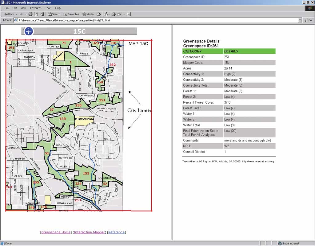
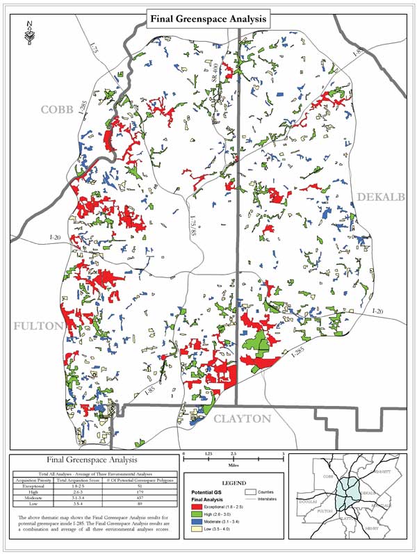
Since the 1970s, metropolitan Atlanta (Metro Atlanta) has been one of the fastest growing regions in the country. Metro Atlanta's population has grown from 1.5 million in 1970 to more than 3.6 million residents in 2000 and this growth does not seem to be slowing. In response to this population increase, Metro Atlanta's geographic boundaries have expanded at an alarming rate. Estimates by the real estate consulting firm Robert Charles Lesser & Co., LLC, show that Metro Atlanta, measured north to south, grew from 68 miles in 1990 to 121 miles in 1997. This kind of explosive growth has earned Atlanta the designation as the nation's poster child for sprawl. The definition of sprawl can be elusive. The public perception of sprawl is driven primarily by concerns that outward expanding, low-density residential development threatens farmland and greenspace. Setting aside land as greenspace is important because it can serve many needs. Greenspace can preserve animal habitat and valuable forest resources; accommodate hiking, biking, and other forms of recreation; and improve water quality by serving as a stream buffer. Funding Greenspace PreservationAlthough Metro Atlanta's sprawling growth over the last 30 years has taken precedence over greenspace preservation, Georgia's state and local governments are now actively pursuing greenspace preservation. In 2000, the Georgia legislature passed Senate Bill 399, which established the Georgia Greenspace Program. This program makes annual grants available to qualifying counties for the acquisition of land that will be permanently protected and preserved as greenspace. To participate in the program, counties must prepare greenspace plans for their jurisdictions that describe in detail how they will permanently protect at least 20 percent of their jurisdictional area as greenspace. Once its initial greenspace plan is submitted and accepted, a participating county need only update the plan annually. Each participating county can also distribute funds to its municipalities as long as the municipalities also create greenspace plans and submit those plans to the managing county. Local governments in Metro Atlanta also have additional incentive to preserve greenspace. The Arthur M. Blank Family Foundation will award approximately $30 million over the next few years to qualifying local governments, nonprofits, and neighborhood groups for the preservation of greenspace inside Metro Atlanta's perimeter highway. The city of Atlanta has a Greenway Acquisition Project that requires the city to spend $25 million over an eight-year period toward the purchase of greenspace along selected portions of streams that have been designated as vital for water quality protection. DeKalb County, one of Metro Atlanta's largest and most populous counties, recently passed a $25 million greenspace bond that will allocate funds for greenspace preservation over the next 20 years. While these greenspace programs have provided Georgia's local governments with incentives to permanently protect greenspace, the task of identifying, prioritizing, and acquiring lands to protect as greenspace can be a daunting task for government agencies that are either understaffed or under budget constraints or both. Furthermore, many of these local governments lack a comprehensive inventory of undeveloped lands or potential greenspaces. Consequently, local governments spent resources trying to locate and prioritize potential greenspace instead of acquiring and setting aside greenspace land. Identifying Potential GreenspaceIn Georgia, nonprofit and nongovernmental agencies actively assist local governments with greenspace preservation efforts. Over the last three years, the Georgia Institute of Technology's Center for Geographic Information Systems (CGIS) has developed the Greenspace Acquisition Support System in partnership with two nonprofit organizations, Trees Atlanta and The Turner Foundation. This GIS-based system aids local governments and nonprofits in preserving greenspace in Metro Atlanta. The Greenspace Acquisition Support System identifies and prioritizes parcels larger than five acres that are important for water quality, urban forest preservation, and the formation of contiguous greenspace systems. Parcels identified as potential greenspace are prioritized by these three project objectives. A greenspace layer is created and overlaid with ownership information and parcel boundaries. The intersection of the prioritized greenspace layer and the parcel boundaries results in a list of ranked greenspace parcels that includes ownership and land value information.
Phase I of the Greenspace Acquisition Support System targeted land inside the city of Atlanta, and Phase II focused on lands inside Atlanta's perimeter highway, Interstate 285. Using ArcView 3.3 and the ArcView Image Analysis extension, the CGIS used color infrared digital orthophotos from 1999 to identify potential greenspace areas. Atlanta is covered by approximately 20 digital orthophoto quarter quadrangles (DOQQs). To increase image drawing speed and enhance project efficiency, CGIS mosaicked and resampled the DOQQs to 1.5-meter resolution using Leica Geosystems IMAGINE software. Park and road layers were then overlaid with the mosaicked DOQQ in ArcView. These layers were used as a geographic reference to guarantee that existing parks (which are already greenspace areas) were not digitized and ensure that potential greenspace areas did not cross roads. These greenspace areas were identified using the mosaicked DOQQ, digitized on-screen as polygons, and saved as a new shapefile. Continued on page 2 |