ArcUser Online
Make Numeric Labels More Readable
Using table number field formatting is a quick solution

These labels, showing the population of various counties in Texas, would be easier to read with some formatting.

To quickly remedy this problem, open the table and right-click the heading for the field used for labeling.
This article as a PDF.
When labeling map features using a numeric field, you may need to add some basic formatting to those numbers. Often, the formatting required can be as simple as inserting a thousands separator character to make values more easily read. Although you could use a labeling expression to accomplish this effect, if you have write permission for the table used for labeling, formatting the labeling field can achieve the same effect more quickly and with less effort.
Changing the way numbers are displayed in tables and labels does not change the underlying data, because this formatting is only saved in the map layer. In addition to inserting thousands separators, this method can be used to adjust alignment, pad a number with zeroes, include a plus sign to indicate a positive number, and specify the number of decimal places or significant digits that will be displayed. Follow this simple procedure to make any of these formatting changes:
- Open the table being used for labeling.
- Right-click the field heading for the field used for labeling and choose Properties. Click the ellipsis button next to Number Format.
- On the Number Format dialog box, choose Numeric and check the box to display a comma separator.
- Click OK to exit all dialog boxes. Click the refresh button on the lower left side of the map canvas to see the formatting changes.
Note: This dialog box can be used to format numbers for currency, directions, percentages, rates, fractions, scientific notation, and angles as well as applying a custom format.
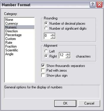
Select Numeric and check the Show thousands separators box.

After closing all dialog boxes, refresh the map to apply the changes.