ArcUser Online
Valuing Mitigation Strategies
A GIS-based approach for climate adaptation analysis
By Sam Merrill, Damon Yakovleff, David Holman, Joe Cooper, and Paul Kirshen
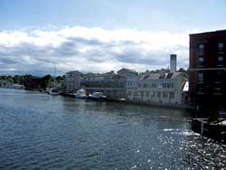
Losses from a flood event were modeled Mystic in Groton, Connecticut.
This article as a PDF.
As more municipalities engage in climate change adaptation planning, better tools to quantify risks to vulnerable assets are needed to facilitate this process. The New England Environmental Finance Center (NE/EFC), with the support of Battelle Memorial Institute, has developed an approach that assesses the costs and benefits of adapting to sea level rise (SLR) scenarios. [NE/EFC works throughout New England to advance the understanding and practice of smart growth, mitigating and adapting strategies for dealing with climate change, and developing alternative energy resources. NE/EFC strives to build local capacity to deal with these and related issues.]
Many tools have been developed by the National Oceanic and Atmospheric Administration (NOAA), the Federal Emergency Management Agency (FEMA), The Nature Conservancy, and other organizations in response to challenges of climate change. These tools focus on the damage caused by SLR or increased storm surges and do not adequately anticipate the cost of damage caused by moving water or include opportunity costs incurred during floods and subsequent damages that render infrastructure unusable. Many existing GIS tools do not calculate or visualize the economic benefits of the adaptive actions municipalities could take in response to different levels of SLR and storm surge.
The Coastal Adaptation to Sea Level Rise Tool (COAST) approach assesses costs and benefits of adaptations to SLR scenarios by incorporating a variety of existing tools and datasets, including the U.S. Army Corps of Engineers' depth-damage functions; NOAA's Sea, Lake, and Overland Surges from Hurricanes (SLOSH) model; and other flood methods, as well as projected SLR scenarios over time, property values, and infrastructure costs, into a comprehensive GIS-based picture of potential economic damage. COAST displays the location-specific avoided costs associated with particular adaptive actions, along with the costs incurred by implementing those actions, to assist coastal municipalities in selecting appropriate strategies.
COAST is not limited to use by coastal cities for quantifying real property loss and other economic vulnerabilities. It has applications for inland areas that include analyzing and displaying the economic impacts of any potential hazard event that can be mapped (e.g., extreme rainfall, fire) as well as the social and environmental impacts of those events. COAST bundles processes in Excel and the ArcGIS ArcGlobe application in the ArcGIS 3D Analyst extension. (COAST requires an ArcGIS Desktop license.) It has been designed to eventually become a stand-alone ArcGIS Desktop extension.
Emergence of Adaptation Interest
The principal response to the problems of SLR and increased storm frequency associated with global climate change has been to reduce greenhouse gas emissions. However, relying exclusively on mitigation as the response to climate change leaves many areas vulnerable, because climate change cannot be reversed now; only the rate can be changed (Intergovernmental Panel on Climate Change [IPCC] 2007 Report Section 3.2). As the world saw with Hurricane Katrina in 2005, present are high vulnerabilities even without additional SLR.
IPCC estimates SLR to have averaged 1.8 millimeters (mm) per year (� 0.5 mm yr�1) between 1961 and 2003, accelerating to 3.1 mm (� 0.7 mm�1) per year since 1993 (S.5.5.2.1, "Changes in Sea Level" in the IPCC Fourth Assessment Report: Climate Change 2007; note also that rate changes from 1961 to 1993 were derived using tide gauge data, whereas 1993�2003 rate changes were derived using TOPEX/Poseidon satellite altimetry). Studies show that expected increases in sea levels will magnify impacts of storm surge flooding. (For a literature review, see Confronting Climate Change in the U.S. Northeast: Science, Impacts, and Solutions. Union of Concerned Scientists, 2007). Municipalities must now adapt to this changing situation using the best information and modeling available.
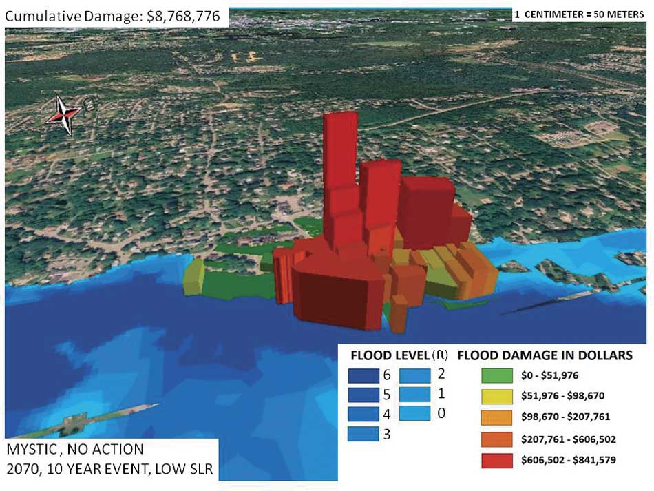
Figure 1: A no-adaptation action scenario modeled for downtown Mystic in Groton, Connecticut. Expected losses in real property and building contents damage from a simulated 10-year flood event projected for 2070 with 1 m of SLR are shown as extruded polygons.
The Visualization Approach
Using 3D capabilities of the ArcGlobe application, economic floodplains can be modeled that show real property and building contents loss, lost infrastructure value, lost economic output, displaced persons, and affected natural resources. The 3D map in Figure 1 models the economic floodplain for downtown Mystic, a portion of Groton, Connecticut. It shows predicted losses related to SLR of 1 m caused by a 10-year flood event when no adaptive actions were taken. (A 10-year flood event is one with a 10 percent chance of occurring every year. Note that a 10-year flood event becomes more likely to occur in the future).
The map displays an event in 2070 and shows cumulative expected losses of $8,768,776 (with a maximum loss of $841,579 for an individual parcel) resulting from damage to real property and building contents. The adaptive actions modeled for this location include installing a hurricane barrier, elevating a road, and building dikes. Each action could provide some protection to the vulnerable areas.
Visually, each action is represented in these maps using the same perspective and showing polygon extrusion for each adaptation action being considered. This is an effective way of showing up-front and maintenance costs of hard-structure approaches versus expected damages from particular inundation events. Soft-structure approaches can also be modeled, such as floodproofing and rezoning over time.
More important, this approach also allows modeling of ranges of SLR heights and storm surge frequency and intensity. Combined outputs of multiple future scenarios provide an opportunity for stakeholders to select future conditions that match their expectations and visualize the predicted damages using both action and no-action scenarios.
Benefits of This Approach
The COAST approach also encompasses more than single event modeling. For multidecade periods, the approach produces cumulative expected damage tallies in tabular form for a given set of conditions and adaptation actions. This allows expected damages from increased flood frequency to be quantified over time as well as identifying robust adaptation strategies that may function acceptably and save money under any climate scenario.
Early applications suggest that parcel-based, graphic display of local vulnerabilities illustrating the likely benefits of taking adaptive actions is a powerful new way to engage local communities in proactive planning in protecting vulnerable economic assets. Work to date has been supported primarily by the U.S. Environmental Protection Agency, in collaboration with ICLEI—Local Governments for Sustainability USA; the Connecticut Department of Environmental Protection; officials in Old Orchard Beach, Maine; and other organizations. Further applications to broaden the suite of expected damage profiles are in development with the U.S. EPA; NOAA; and several cities, including Portland, Maine.
For more information, contact
Sam Merrill, Ph.D.
Director, New England Environmental Finance Center
Assistant Research Professor
Muskie School of Public Service
University of Southern Maine
Portland, Maine 04069
Tel.: 207-228-8596
E-mail: smerrill@usm.maine.edu
About the Authors
Sam Merrill, Ph.D., has been with the Muskie School of Public Service for nine years. Previously, he worked for the Minnesota Department of Natural Resources. His graduate work was in the area of GPS radiotelemetry on large carnivores.
Damon Yakovleff is a graduate student studying community planning and development at the University of Southern Maine's Muskie School of Public Service.
David Holman is an MBA candidate at the University of Southern Maine's School of Business.
Joe Cooper is a utility engineer technician; a supervisor for the City of Saco, Maine; and a freelance GIS analyst.
Dr. Paul Kirshen joined Battelle as research leader in June 2009 after 13 years at Tufts University as cofounder and director of the Tufts University Water: Systems, Science, and Society (WSSS) Interdisciplinary Research and Graduate Education Program and research professor in civil and environmental engineering. He has 30 years of experience in the management of complex, interdisciplinary, stakeholder-driven projects and research with many investigators and institutions related to climate variability and change, the coastal zone, and water resources.