ArcUser Online
GIS-ing Flood Data
Making valuable information in paper studies accessible
By Mehdi Mashud Khan, Randall Vogel, and Ronald O. Edwards, Polk County Board of County Commissioners
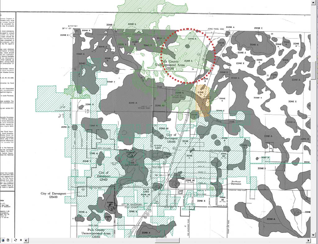
Some areas of concern are not shown on FEMA maps. The area marked by red dots shows that the localized flood study (rendered in green hatch) identifies potential flood zones that were not included in FEMA maps (rendered in solid dark gray).
This article as a PDF.
Polk County, Florida, has acquired a significant number of detailed local flood studies over the last 20 years. These studies—the result of a county requirement—are being converted from paper documents to GIS layers to provide valuable flood protection information to county residents.
Flooding is one of the most common natural hazards in Polk County, as it is in many other parts of the United States. Approximately 46 percent of the county is located in one of the Federal Emergency Management Agency (FEMA) Special Flood Hazard Area (SFHA) designations. A significant percentage of the county's population lives or works in areas that are at risk of flooding. Because Polk is in Florida, it is also susceptible to seasonal hurricanes that can cause severe flooding.
In 2004, three hurricanes that passed through the county resulted in standing water all over the county and caused rivers to overflow and flood adjacent communities. Any prolonged rainfall has the potential to result in flooding. The county's flat topography, combined with expanding development, causes storm water to reach buildings quickly because water moves across the surface more rapidly than it can be absorbed into the ground. The same factors also delay the departure of floodwaters.
Mitigation Activities
To minimize flood damage, Polk County has undertaken flood protection activities (e.g., periodic ditch and channel cleaning, maintaining flood-prone areas as open space) along with the introduction of flood protection regulations. As part of this effort, the county requires that new residential buildings or buildings that are substantially improved be elevated one foot above the base flood elevation (BFE).
This ordinance means that information on the flood zone and the base flood elevation for a site must be known for these properties. To help determine the flood zones and BFEs, FEMA provides paper and online maps. In some cases, these maps may supply sufficient information. However, in many instances, FEMA maps lack sufficient detail because they were prepared 10 or more years ago using 5- to 10-foot contour data. At that scale, a parcel or a small piece of land can easily be lost.
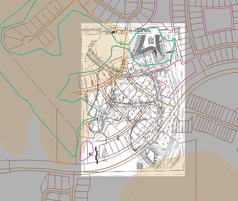
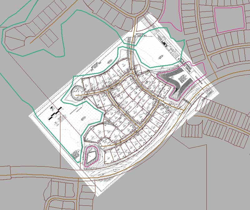
The image above is a scanned unaligned study area that needs to be georeferenced. The image below shows an image of the same area that has been georeferenced. It has been rotated, stretched, and aligned.
Although FEMA maps were updated in 2000, many updated maps are based on maps prepared in 1983. FEMA maps might recognize a potential flood hazard area but lack detailed information such as BFEs or the extent of flooding. In a worst-case scenario, FEMA maps may have completely inaccurate information or lack any information at all.
County Response
The county has addressed this issue by requiring detailed flood studies for any proposed development larger than five acres or 50 lots. Over the years, the county has acquired a significant number of studies for many developments within its jurisdiction. These studies, submitted and stored in the county in paper format, are a great resource for the county, not only for the developments for which they were created but also for future developments in the same area. Because flood studies are based on topographic features, these studies can provide flood-specific information for adjacent areas and supply required information for future developments. Even if a study is contained within the area, that study can be used as the basis for future studies of adjacent areas. In both scenarios, access to this information can substantially reduce costs.
If existing studies are not available, residential and commercial developers must perform expensive flood studies to determine the BFE for a site. To relieve individual parcel owners or developers with projects of less than five acres of this expense, the county also accepts an alternative method of compliance. It specifies that new structures be built three feet above the "highest adjacent grade" (i.e., the highest elevation on the lot) if a BFE is unavailable. Although this meets the county requirement, a lack of information can result in requiring a parcel owner to pay a lot for flood insurance. Consequently, individual owners can benefit from going through old flood studies of adjacent properties. This information can not only save money on flood insurance but also help owners choose appropriate construction materials and techniques.
Making Studies Accessible
Currently, flood studies are available only as paper documents. To respond to a request to determine if property is located in an area prone to flooding (and must meet FEMA floodplain management requirements), legal descriptions are used to locate the parcel on an appropriate study and get pertinent information. This process, which is tedious and lengthy and wastes staff time, has all the limitations of paper-based media in terms of archiving, organizing, and searching flood studies.
Sometimes flood studies are divided into parts and represented in several drawings. It is inconvenient to combine these paper drawings so the whole picture can be seen. It is also challenging to view these studies in conjunction with other data. This is a long, painstaking, manual process. To use these studies more effectively, the Land Development Division decided to convert them from paper to a digital format so the department could find the information quickly and would make flood studies accessible to a wider audience. They could be seamlessly analyzed and explored in the context of other relevant data.
GIS was the obvious answer. Converting these flood studies to GIS layers would allow users to take advantage of sophisticated analysis tools to explore them in conjunction with other relevant GIS data. Departments could store these studies in a relational database management system, thus making it accessible through the county network. The county could also provide this information to the public through Web GIS and eliminate the labor associated with the previous process.
To achieve these goals, the county's Floodplain Management and GIS sections teamed up to complete the conversion process and create an informative and useful flood GIS layer.
Conversion Process
The ArcGIS Desktop environment was chosen for the conversion because of its advanced tools, existing database environment, and low learning curve. The conversion process included the following steps:
- Search paper flood studies for the base information that will help locate any data that should be added.
- Locate the study site. Because studies are basically survey drawings, they have range, township, and section information that can be used to track down the site. Survey notes can be used to create the boundary if no parcel or subdivision lines are available.
- Check the validity of the study. New information might be available for the same area from a different permit. Floodplain Management staff needs to be consulted in determining that.
- Find out which datum was used (e.g., National Geodetic Vertical Datum of 1929 [ft. NAVD 29] or North American Vertical Datum of 1988 [ft. NAVD 88]).
- Consult submitted paperwork for storm water calculations if the BFE is not on the drawings.
- Scan the paper drawing using a large-format scanner.
- Georeference the scanned images, because they do not have any spatial information. To properly incorporate these images with other study area data, align spatial data to the image file using tools in ArcGIS.
- Use editing and drawing tools in ArcGIS to digitize the studies and save them in the GIS.
- Add attribute data along with flood-specific information (e.g., the study site name, name of the engineering firm, study year).
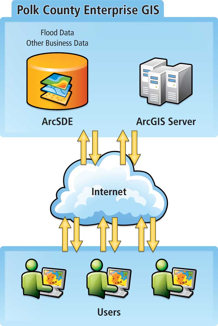
The process for accessing flood information
Impact and Benefits
Once this new GIS layer is completed, it will be a great source of information for Polk County Floodplain Management and its customers. The parcel layer is overlaid on the floodplain layer so county employees can quickly locate a parcel and determine the proximity of BFE and flood zones to that parcel. This will provide valuable flood information to landowners without requiring an expensive flood study. Planners will also have better information for flood management.
Potentially, this layer could be used online by county residents through Web GIS. By eliminating the need to contact the county, the county employee workload would be significantly reduced, saving money for the county and, ultimately, its residents. With the help of ArcGIS Server technology, users could not only acquire flood information but also perform GIS analysis online without actually learning GIS. For example, a user could find the locations of flood insurance offices or emergency shelters within a certain drive time or distance from a parcel and perhaps generate optimized routes to and from those locations.
These tools will help educate county residents so they can protect themselves before and during a flood. These activities could also allow residents to benefit from lower flood insurance rates. [The National Flood Insurance Program (NFIP) offers reasonably priced flood insurance for communities that comply with its minimum standards for floodplain management. NFIP's Community Rating System (CRS), a voluntary program, provides incentives for communities that exceed minimum standards.] This upgrade will significantly improve all four factors that CRS considers: public information, mapping and regulations, flood damage reduction, and flood preparedness. These improvements could enhance the CRS rating for Polk County, resulting in lower flood insurance rates for county homeowners and renters.
Conclusion
Currently, about 25 percent of the flood studies have been incorporated in the GIS. Once completed, this will be a major source for flood protection data that can be accessed, analyzed, and shared internally and externally. It will significantly save time and money for the county and its residents. This method retrieves information more effectively than the current paper process with paper data.
For more information, contact
Mehdi Mashud Khan, GISP, GIS Supervisor
Polk County Board of County Commissioners
E-mail: mehdikhan@polk-county.net
Tel.: 863-534-7518
About the Authors
Mehdi Mashud Khan (primary author) manages the GIS team at the Polk County IT in Bartow, Florida. He has a decade of experience as a GIS professional with responsibilities ranging from application development, administering Web GIS, and database management to GIS analysis and data editing. Prior to joining Polk County, he was a GIS manager at the Department of Health and Environmental Control in South Carolina. His area of interest is creating a total GIS for state/local governments that will integrate and serve diverse government units and improve their services. Khan, who started his career as a design architecture, CAD, and visualization expert, is also very interested in integrating CAD, building information modeling, and GIS.
Randall Vogel (coauthor) has more than five years of experience with FEMA floodplain regulatory and insurance processes. His primary professional interests include ensuring that flood map regulatory data is used in a way that encourages safe and sustainable development of land and water resources. He also has experience in policy design, analysis, and implementation.
Ronald O. Edwards (coauthor) has been working as a GIS technician at Polk County IT/GIS for the last six years. Prior to joining the GIS team, he worked with the county utilities department for nine years assisting engineers with water/wastewater design. Edwards, who is passionate about the environment, started his professional career in that field. He has a bachelor's degree in business administration and an associate's degree in environmental engineering.